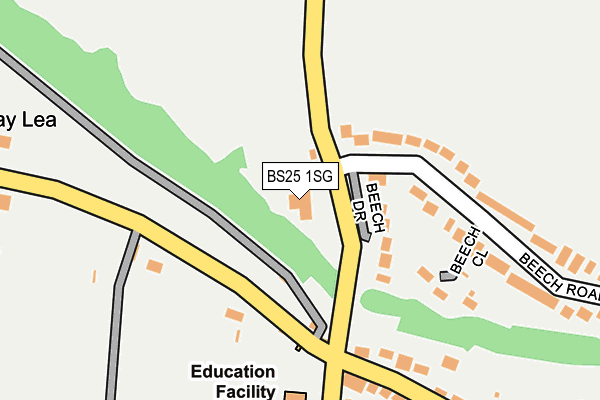
BS25 1SG is located in the Cheddar electoral ward, within the unitary authority of Somerset and the English Parliamentary constituency of Wells. The Sub Integrated Care Board (ICB) Location is NHS Somerset ICB - 11X and the police force is Avon and Somerset. This postcode has been in use since July 2005.


GetTheData
Source: OS OpenMap – Local (Ordnance Survey)
Source: OS VectorMap District (Ordnance Survey)
Licence: Open Government Licence (requires attribution)
| Easting | 344419 |
| Northing | 157909 |
| Latitude | 51.317556 |
| Longitude | -2.798925 |
GetTheData
Source: Open Postcode Geo
Licence: Open Government Licence
| Country | England |
| Postcode District | BS25 |
| ➜ BS25 open data dashboard ➜ See where BS25 is on a map ➜ Where is Shipham? | |
GetTheData
Source: Land Registry Price Paid Data
Licence: Open Government Licence
Elevation or altitude of BS25 1SG as distance above sea level:
| Metres | Feet | |
|---|---|---|
| Elevation | 130m | 427ft |
Elevation is measured from the approximate centre of the postcode, to the nearest point on an OS contour line from OS Terrain 50, which has contour spacing of ten vertical metres.
➜ How high above sea level am I? Find the elevation of your current position using your device's GPS.
GetTheData
Source: Open Postcode Elevation
Licence: Open Government Licence
| Ward | Cheddar |
| Constituency | Wells |
GetTheData
Source: ONS Postcode Database
Licence: Open Government Licence
| June 2022 | Public order | On or near Sycamore Close | 255m |
| June 2022 | Violence and sexual offences | On or near New Road | 280m |
| June 2022 | Vehicle crime | On or near Hind Pitts | 411m |
| ➜ Get more crime data in our Crime section | |||
GetTheData
Source: data.police.uk
Licence: Open Government Licence
| Turnpike Cottage (New Road) | Shipham | 144m |
| Turnpike Cottage (New Road) | Shipham | 148m |
| The Bus Shelter (New Road) | Shipham | 177m |
| The Miners Arms (The Square) | Shipham | 389m |
| The Miners Arms (Hind Pitts) | Shipham | 401m |
GetTheData
Source: NaPTAN
Licence: Open Government Licence
GetTheData
Source: ONS Postcode Database
Licence: Open Government Licence


➜ Get more ratings from the Food Standards Agency
GetTheData
Source: Food Standards Agency
Licence: FSA terms & conditions
| Last Collection | |||
|---|---|---|---|
| Location | Mon-Fri | Sat | Distance |
| Rowberrow | 16:30 | 10:00 | 716m |
| Belmont | 17:00 | 10:30 | 2,040m |
| Moorham Road | 16:15 | 09:30 | 2,484m |
GetTheData
Source: Dracos
Licence: Creative Commons Attribution-ShareAlike
| Facility | Distance |
|---|---|
| Shipham Afc New Road, Shipham, Winscombe Grass Pitches | 2m |
| Sidcot School Oakridge Lane, Winscombe Health and Fitness Gym, Sports Hall, Swimming Pool, Squash Courts | 1.6km |
| Mendip Activity Centre Lyncombe Drive, Sandford, Winscombe Ski Slopes | 1.7km |
GetTheData
Source: Active Places
Licence: Open Government Licence
| School | Phase of Education | Distance |
|---|---|---|
| Shipham Church of England First School Turnpike Road, Shipham, Winscombe, BS25 1TX | Primary | 264m |
| Sidcot School Oakridge Lane, Winscombe, BS25 1PD | Not applicable | 1.6km |
| Winscombe Primary School Moorham Road, Winscombe, BS25 1HH | Primary | 2.1km |
GetTheData
Source: Edubase
Licence: Open Government Licence
The below table lists the International Territorial Level (ITL) codes (formerly Nomenclature of Territorial Units for Statistics (NUTS) codes) and Local Administrative Units (LAU) codes for BS25 1SG:
| ITL 1 Code | Name |
|---|---|
| TLK | South West (England) |
| ITL 2 Code | Name |
| TLK2 | Dorset and Somerset |
| ITL 3 Code | Name |
| TLK23 | Somerset CC |
| LAU 1 Code | Name |
| E07000188 | Sedgemoor |
GetTheData
Source: ONS Postcode Directory
Licence: Open Government Licence
The below table lists the Census Output Area (OA), Lower Layer Super Output Area (LSOA), and Middle Layer Super Output Area (MSOA) for BS25 1SG:
| Code | Name | |
|---|---|---|
| OA | E00148367 | |
| LSOA | E01029128 | Sedgemoor 001D |
| MSOA | E02006061 | Sedgemoor 001 |
GetTheData
Source: ONS Postcode Directory
Licence: Open Government Licence
| BS25 1SH | Beech Drive | 84m |
| BS25 1UA | Broadway | 130m |
| BS25 1SD | Beech Close | 165m |
| BS25 1SA | Beech Road | 210m |
| BS25 1SL | North Down Lane | 220m |
| BS25 1SB | Beech Road | 239m |
| BS25 1TX | Turnpike Road | 250m |
| BS25 1TY | Sycamore Close | 276m |
| BS25 1TS | Kenmeade Close | 283m |
| BS25 1TP | Comrade Avenue | 325m |
GetTheData
Source: Open Postcode Geo; Land Registry Price Paid Data
Licence: Open Government Licence