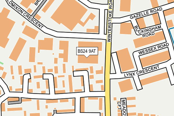
BS24 9AT lies on Winterstoke Road in Weston-super-mare. BS24 9AT is located in the Weston-super-Mare South electoral ward, within the unitary authority of North Somerset and the English Parliamentary constituency of Weston-Super-Mare. The Sub Integrated Care Board (ICB) Location is NHS Bristol, North Somerset and South Gloucestershire ICB - 15C and the police force is Avon and Somerset. This postcode has been in use since October 1985.


GetTheData
Source: OS OpenMap – Local (Ordnance Survey)
Source: OS VectorMap District (Ordnance Survey)
Licence: Open Government Licence (requires attribution)
| Easting | 333502 |
| Northing | 158904 |
| Latitude | 51.325332 |
| Longitude | -2.955732 |
GetTheData
Source: Open Postcode Geo
Licence: Open Government Licence
| Street | Winterstoke Road |
| Town/City | Weston-super-mare |
| Country | England |
| Postcode District | BS24 |
➜ See where BS24 is on a map | |
GetTheData
Source: Land Registry Price Paid Data
Licence: Open Government Licence
Elevation or altitude of BS24 9AT as distance above sea level:
| Metres | Feet | |
|---|---|---|
| Elevation | 10m | 33ft |
Elevation is measured from the approximate centre of the postcode, to the nearest point on an OS contour line from OS Terrain 50, which has contour spacing of ten vertical metres.
➜ How high above sea level am I? Find the elevation of your current position using your device's GPS.
GetTheData
Source: Open Postcode Elevation
Licence: Open Government Licence
| Ward | Weston-super-mare South |
| Constituency | Weston-super-mare |
GetTheData
Source: ONS Postcode Database
Licence: Open Government Licence
| Bloomfield (Brompton Road) | Oldmixon | 121m |
| Bloomfield (Brompton Road) | Oldmixon | 130m |
| Oldmixon Crescent (Winterstoke Road) | Oldmixon | 137m |
| Oldmixon Crescent | Oldmixon | 174m |
| Walnut Tree Inn (Winterstoke Road) | Oldmixon | 213m |
| Weston-super-Mare Station | 2.4km |
| Weston Milton Station | 2.7km |
| Worle Station | 4.9km |
GetTheData
Source: NaPTAN
Licence: Open Government Licence
GetTheData
Source: ONS Postcode Database
Licence: Open Government Licence


➜ Get more ratings from the Food Standards Agency
GetTheData
Source: Food Standards Agency
Licence: FSA terms & conditions
| Last Collection | |||
|---|---|---|---|
| Location | Mon-Fri | Sat | Distance |
| Aller Parade Post Office | 17:30 | 12:15 | 1,493m |
| Phillips Road | 18:00 | 11:30 | 1,783m |
| Drove Road | 17:45 | 13:00 | 1,931m |
GetTheData
Source: Dracos
Licence: Creative Commons Attribution-ShareAlike
| Risk of BS24 9AT flooding from rivers and sea | Low |
| ➜ BS24 9AT flood map | |
GetTheData
Source: Open Flood Risk by Postcode
Licence: Open Government Licence
The below table lists the International Territorial Level (ITL) codes (formerly Nomenclature of Territorial Units for Statistics (NUTS) codes) and Local Administrative Units (LAU) codes for BS24 9AT:
| ITL 1 Code | Name |
|---|---|
| TLK | South West (England) |
| ITL 2 Code | Name |
| TLK1 | Gloucestershire, Wiltshire and Bath/Bristol area |
| ITL 3 Code | Name |
| TLK12 | Bath and North East Somerset, North Somerset and South Gloucestershire |
| LAU 1 Code | Name |
| E06000024 | North Somerset |
GetTheData
Source: ONS Postcode Directory
Licence: Open Government Licence
The below table lists the Census Output Area (OA), Lower Layer Super Output Area (LSOA), and Middle Layer Super Output Area (MSOA) for BS24 9AT:
| Code | Name | |
|---|---|---|
| OA | E00074938 | |
| LSOA | E01014828 | North Somerset 025C |
| MSOA | E02003089 | North Somerset 025 |
GetTheData
Source: ONS Postcode Directory
Licence: Open Government Licence
| BS24 9BW | Brompton Road | 71m |
| BS24 9BN | Brompton Road | 87m |
| BS24 9BS | Brompton Road | 117m |
| BS24 9BT | Brompton Road | 169m |
| BS24 9DB | Monkton Avenue | 176m |
| BS24 9BU | Brompton Road | 181m |
| BS24 9DD | Aller Parade | 210m |
| BS24 9XE | Meadow Croft | 217m |
| BS24 9AY | Oldmixon Crescent | 219m |
| BS24 9DE | Monkton Avenue | 233m |
GetTheData
Source: Open Postcode Geo; Land Registry Price Paid Data
Licence: Open Government Licence