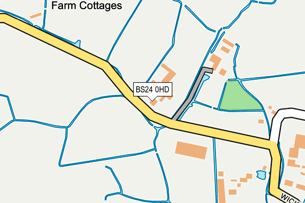
BS24 0HD lies on Brean Road in Lympsham, Weston-super-mare. BS24 0HD is located in the Brent electoral ward, within the unitary authority of Somerset and the English Parliamentary constituency of Wells. The Sub Integrated Care Board (ICB) Location is NHS Somerset ICB - 11X and the police force is Avon and Somerset. This postcode has been in use since January 1980.


GetTheData
Source: OS OpenMap – Local (Ordnance Survey)
Source: OS VectorMap District (Ordnance Survey)
Licence: Open Government Licence (requires attribution)
| Easting | 331536 |
| Northing | 154896 |
| Latitude | 51.289061 |
| Longitude | -2.983180 |
GetTheData
Source: Open Postcode Geo
Licence: Open Government Licence
| Street | Brean Road |
| Locality | Lympsham |
| Town/City | Weston-super-mare |
| Country | England |
| Postcode District | BS24 |
➜ See where BS24 is on a map | |
GetTheData
Source: Land Registry Price Paid Data
Licence: Open Government Licence
Elevation or altitude of BS24 0HD as distance above sea level:
| Metres | Feet | |
|---|---|---|
| Elevation | 10m | 33ft |
Elevation is measured from the approximate centre of the postcode, to the nearest point on an OS contour line from OS Terrain 50, which has contour spacing of ten vertical metres.
➜ How high above sea level am I? Find the elevation of your current position using your device's GPS.
GetTheData
Source: Open Postcode Elevation
Licence: Open Government Licence
| Ward | Brent |
| Constituency | Wells |
GetTheData
Source: ONS Postcode Database
Licence: Open Government Licence
| Wick Turn (Wick Road) | Lympsham | 943m |
| Ham Farm (Ham Road) | Brean | 950m |
| Wick Turn (Wick Road) | Lympsham | 952m |
| Ham Farm (Ham Road) | Brean | 954m |
| Animal Farm Adventure Park | Brean | 1,032m |
GetTheData
Source: NaPTAN
Licence: Open Government Licence
| Percentage of properties with Next Generation Access | 0.0% |
| Percentage of properties with Superfast Broadband | 0.0% |
| Percentage of properties with Ultrafast Broadband | 0.0% |
| Percentage of properties with Full Fibre Broadband | 0.0% |
Superfast Broadband is between 30Mbps and 300Mbps
Ultrafast Broadband is > 300Mbps
| Median download speed | 3.6Mbps |
| Average download speed | 3.4Mbps |
| Maximum download speed | 6.49Mbps |
| Median upload speed | 0.9Mbps |
| Average upload speed | 0.8Mbps |
| Maximum upload speed | 1.01Mbps |
| Percentage of properties unable to receive 2Mbps | 0.0% |
| Percentage of properties unable to receive 5Mbps | 0.0% |
| Percentage of properties unable to receive 10Mbps | 88.9% |
| Percentage of properties unable to receive 30Mbps | 100.0% |
GetTheData
Source: Ofcom
Licence: Ofcom Terms of Use (requires attribution)
GetTheData
Source: ONS Postcode Database
Licence: Open Government Licence


➜ Get more ratings from the Food Standards Agency
GetTheData
Source: Food Standards Agency
Licence: FSA terms & conditions
| Last Collection | |||
|---|---|---|---|
| Location | Mon-Fri | Sat | Distance |
| Plimleys Garage | 16:00 | 10:00 | 2,028m |
| Veale Site Bleadon | 17:30 | 11:15 | 3,537m |
| Gore Road | 16:45 | 12:00 | 4,670m |
GetTheData
Source: Dracos
Licence: Creative Commons Attribution-ShareAlike
| Risk of BS24 0HD flooding from rivers and sea | High |
| ➜ BS24 0HD flood map | |
GetTheData
Source: Open Flood Risk by Postcode
Licence: Open Government Licence
The below table lists the International Territorial Level (ITL) codes (formerly Nomenclature of Territorial Units for Statistics (NUTS) codes) and Local Administrative Units (LAU) codes for BS24 0HD:
| ITL 1 Code | Name |
|---|---|
| TLK | South West (England) |
| ITL 2 Code | Name |
| TLK2 | Dorset and Somerset |
| ITL 3 Code | Name |
| TLK23 | Somerset CC |
| LAU 1 Code | Name |
| E07000188 | Sedgemoor |
GetTheData
Source: ONS Postcode Directory
Licence: Open Government Licence
The below table lists the Census Output Area (OA), Lower Layer Super Output Area (LSOA), and Middle Layer Super Output Area (MSOA) for BS24 0HD:
| Code | Name | |
|---|---|---|
| OA | E00148150 | |
| LSOA | E01032633 | Sedgemoor 002G |
| MSOA | E02006062 | Sedgemoor 002 |
GetTheData
Source: ONS Postcode Directory
Licence: Open Government Licence
| TA8 2RW | Red Road | 1051m |
| BS24 0EU | Rectory Way | 1069m |
| BS24 0ES | Millfield Cottages | 1091m |
| BS24 0AP | Accommodation Road | 1154m |
| BS24 0HG | Wick Lane | 1454m |
| BS24 0EX | Batch Lane | 1494m |
| BS24 0EN | Rectory Way | 1688m |
| BS24 0EW | Rectory Way | 1876m |
| TA8 2RX | Wesley Close | 1945m |
| TA8 2SE | South Road | 1961m |
GetTheData
Source: Open Postcode Geo; Land Registry Price Paid Data
Licence: Open Government Licence