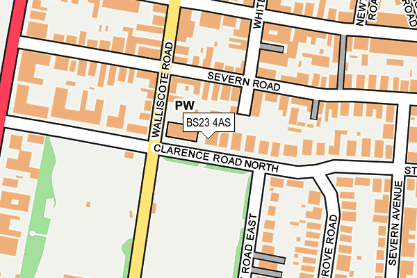
BS23 4AS is located in the Weston-super-Mare Central electoral ward, within the unitary authority of North Somerset and the English Parliamentary constituency of Weston-Super-Mare. The Sub Integrated Care Board (ICB) Location is NHS Bristol, North Somerset and South Gloucestershire ICB - 15C and the police force is Avon and Somerset. This postcode has been in use since January 1980.


GetTheData
Source: OS OpenMap – Local (Ordnance Survey)
Source: OS VectorMap District (Ordnance Survey)
Licence: Open Government Licence (requires attribution)
| Easting | 332010 |
| Northing | 160296 |
| Latitude | 51.337670 |
| Longitude | -2.977408 |
GetTheData
Source: Open Postcode Geo
Licence: Open Government Licence
| Country | England |
| Postcode District | BS23 |
| ➜ BS23 open data dashboard ➜ See where BS23 is on a map ➜ Where is Weston-Super-Mare? | |
GetTheData
Source: Land Registry Price Paid Data
Licence: Open Government Licence
Elevation or altitude of BS23 4AS as distance above sea level:
| Metres | Feet | |
|---|---|---|
| Elevation | 10m | 33ft |
Elevation is measured from the approximate centre of the postcode, to the nearest point on an OS contour line from OS Terrain 50, which has contour spacing of ten vertical metres.
➜ How high above sea level am I? Find the elevation of your current position using your device's GPS.
GetTheData
Source: Open Postcode Elevation
Licence: Open Government Licence
| Ward | Weston-super-mare Central |
| Constituency | Weston-super-mare |
GetTheData
Source: ONS Postcode Database
Licence: Open Government Licence
| June 2022 | Anti-social behaviour | On or near Supermarket | 132m |
| June 2022 | Violence and sexual offences | On or near Conference/Exhibition Centre | 192m |
| June 2022 | Public order | On or near Conference/Exhibition Centre | 192m |
| ➜ Get more crime data in our Crime section | |||
GetTheData
Source: data.police.uk
Licence: Open Government Licence
| St Pauls Church (Walliscote Road) | Clarence Park | 82m |
| Walliscote Road (Severn Road) | Clarence Park | 105m |
| Severn Road Shops (Severn Road) | Clarence Park | 140m |
| Severn Road (Walliscote Road) | Clarence Park | 164m |
| Clarence Road South | Clarence Park | 225m |
| Weston-super-Mare Station | 0.8km |
| Weston Milton Station | 2.7km |
| Worle Station | 5.2km |
GetTheData
Source: NaPTAN
Licence: Open Government Licence
| Percentage of properties with Next Generation Access | 100.0% |
| Percentage of properties with Superfast Broadband | 100.0% |
| Percentage of properties with Ultrafast Broadband | 100.0% |
| Percentage of properties with Full Fibre Broadband | 0.0% |
Superfast Broadband is between 30Mbps and 300Mbps
Ultrafast Broadband is > 300Mbps
| Percentage of properties unable to receive 2Mbps | 0.0% |
| Percentage of properties unable to receive 5Mbps | 0.0% |
| Percentage of properties unable to receive 10Mbps | 0.0% |
| Percentage of properties unable to receive 30Mbps | 0.0% |
GetTheData
Source: Ofcom
Licence: Ofcom Terms of Use (requires attribution)
GetTheData
Source: ONS Postcode Database
Licence: Open Government Licence


➜ Get more ratings from the Food Standards Agency
GetTheData
Source: Food Standards Agency
Licence: FSA terms & conditions
| Last Collection | |||
|---|---|---|---|
| Location | Mon-Fri | Sat | Distance |
| Railway Station | 18:30 | 12:45 | 854m |
| Town Hall | 18:30 | 12:45 | 943m |
| Regent Street Post Office | 18:30 | 13:00 | 1,061m |
GetTheData
Source: Dracos
Licence: Creative Commons Attribution-ShareAlike
| Facility | Distance |
|---|---|
| Clarence Park Clarence Road East, Weston-super-mare Grass Pitches | 118m |
| Total Fitness Concept (Closed) Whitecross Road, Weston-super-mare Studio, Health and Fitness Gym | 164m |
| Body Tone (Closed) Whitecross Road, Weston-super-mare Health and Fitness Gym | 171m |
GetTheData
Source: Active Places
Licence: Open Government Licence
| School | Phase of Education | Distance |
|---|---|---|
| Corpus Christi Catholic Primary School Ellenborough Park South, Weston-super-Mare, BS23 1XW | Primary | 441m |
| Walliscote Primary School Walliscote Road, Weston-Super-Mare, BS23 1UY | Primary | 815m |
| Hans Price Academy Marchfields Way, Weston-super-Mare, BS23 3QP | Secondary | 910m |
GetTheData
Source: Edubase
Licence: Open Government Licence
The below table lists the International Territorial Level (ITL) codes (formerly Nomenclature of Territorial Units for Statistics (NUTS) codes) and Local Administrative Units (LAU) codes for BS23 4AS:
| ITL 1 Code | Name |
|---|---|
| TLK | South West (England) |
| ITL 2 Code | Name |
| TLK1 | Gloucestershire, Wiltshire and Bath/Bristol area |
| ITL 3 Code | Name |
| TLK12 | Bath and North East Somerset, North Somerset and South Gloucestershire |
| LAU 1 Code | Name |
| E06000024 | North Somerset |
GetTheData
Source: ONS Postcode Directory
Licence: Open Government Licence
The below table lists the Census Output Area (OA), Lower Layer Super Output Area (LSOA), and Middle Layer Super Output Area (MSOA) for BS23 4AS:
| Code | Name | |
|---|---|---|
| OA | E00074798 | |
| LSOA | E01014806 | North Somerset 022B |
| MSOA | E02003086 | North Somerset 022 |
GetTheData
Source: ONS Postcode Directory
Licence: Open Government Licence
| BS23 1EH | Whitecross Road | 74m |
| BS23 1DP | Severn Road | 79m |
| BS23 4AW | Clarence Road North | 80m |
| BS23 1EF | Walliscote Road | 108m |
| BS23 4AT | Clarence Road North | 127m |
| BS23 4BT | Clarence Road East | 135m |
| BS23 1DT | Severn Road | 138m |
| BS23 1EJ | Whitecross Road | 149m |
| BS23 1DR | Severn Road | 162m |
| BS23 1EE | Walliscote Road | 163m |
GetTheData
Source: Open Postcode Geo; Land Registry Price Paid Data
Licence: Open Government Licence