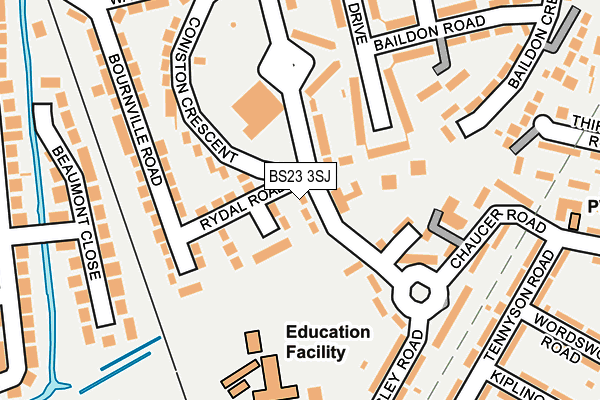
BS23 3SJ lies on Lonsdale Avenue in Weston-super-mare. BS23 3SJ is located in the Weston-super-Mare South electoral ward, within the unitary authority of North Somerset and the English Parliamentary constituency of Weston-Super-Mare. The Sub Integrated Care Board (ICB) Location is NHS Bristol, North Somerset and South Gloucestershire ICB - 15C and the police force is Avon and Somerset. This postcode has been in use since January 1980.


GetTheData
Source: OS OpenMap – Local (Ordnance Survey)
Source: OS VectorMap District (Ordnance Survey)
Licence: Open Government Licence (requires attribution)
| Easting | 332857 |
| Northing | 159576 |
| Latitude | 51.331294 |
| Longitude | -2.965121 |
GetTheData
Source: Open Postcode Geo
Licence: Open Government Licence
| Street | Lonsdale Avenue |
| Town/City | Weston-super-mare |
| Country | England |
| Postcode District | BS23 |
➜ See where BS23 is on a map ➜ Where is Weston-Super-Mare? | |
GetTheData
Source: Land Registry Price Paid Data
Licence: Open Government Licence
Elevation or altitude of BS23 3SJ as distance above sea level:
| Metres | Feet | |
|---|---|---|
| Elevation | 10m | 33ft |
Elevation is measured from the approximate centre of the postcode, to the nearest point on an OS contour line from OS Terrain 50, which has contour spacing of ten vertical metres.
➜ How high above sea level am I? Find the elevation of your current position using your device's GPS.
GetTheData
Source: Open Postcode Elevation
Licence: Open Government Licence
| Ward | Weston-super-mare South |
| Constituency | Weston-super-mare |
GetTheData
Source: ONS Postcode Database
Licence: Open Government Licence
| Windwistle Circle (Windwhistle Circle) | Bourneville | 115m |
| Windwistle Circle | Bourneville | 166m |
| Lonsdale Avenue | Bourneville | 177m |
| Lonsdale Avenue | Bourneville | 191m |
| Thirlmere Road | Bourneville | 337m |
| Weston-super-Mare Station | 1.5km |
| Weston Milton Station | 2.5km |
| Worle Station | 4.9km |
GetTheData
Source: NaPTAN
Licence: Open Government Licence
| Percentage of properties with Next Generation Access | 100.0% |
| Percentage of properties with Superfast Broadband | 100.0% |
| Percentage of properties with Ultrafast Broadband | 0.0% |
| Percentage of properties with Full Fibre Broadband | 0.0% |
Superfast Broadband is between 30Mbps and 300Mbps
Ultrafast Broadband is > 300Mbps
| Median download speed | 43.8Mbps |
| Average download speed | 41.8Mbps |
| Maximum download speed | 68.64Mbps |
| Median upload speed | 16.2Mbps |
| Average upload speed | 13.6Mbps |
| Maximum upload speed | 20.00Mbps |
| Percentage of properties unable to receive 2Mbps | 0.0% |
| Percentage of properties unable to receive 5Mbps | 0.0% |
| Percentage of properties unable to receive 10Mbps | 0.0% |
| Percentage of properties unable to receive 30Mbps | 0.0% |
GetTheData
Source: Ofcom
Licence: Ofcom Terms of Use (requires attribution)
Estimated total energy consumption in BS23 3SJ by fuel type, 2015.
| Consumption (kWh) | 60,798 |
|---|---|
| Meter count | 6 |
| Mean (kWh/meter) | 10,133 |
| Median (kWh/meter) | 10,078 |
| Consumption (kWh) | 27,563 |
|---|---|
| Meter count | 6 |
| Mean (kWh/meter) | 4,594 |
| Median (kWh/meter) | 4,398 |
GetTheData
Source: Postcode level gas estimates: 2015 (experimental)
Source: Postcode level electricity estimates: 2015 (experimental)
Licence: Open Government Licence
GetTheData
Source: ONS Postcode Database
Licence: Open Government Licence


➜ Get more ratings from the Food Standards Agency
GetTheData
Source: Food Standards Agency
Licence: FSA terms & conditions
| Last Collection | |||
|---|---|---|---|
| Location | Mon-Fri | Sat | Distance |
| Phillips Road | 18:00 | 11:30 | 1,198m |
| Drove Road | 17:45 | 13:00 | 1,306m |
| Weston Super Mare Post Office | 18:00 | 13:15 | 1,466m |
GetTheData
Source: Dracos
Licence: Creative Commons Attribution-ShareAlike
| Risk of BS23 3SJ flooding from rivers and sea | Low |
| ➜ BS23 3SJ flood map | |
GetTheData
Source: Open Flood Risk by Postcode
Licence: Open Government Licence
The below table lists the International Territorial Level (ITL) codes (formerly Nomenclature of Territorial Units for Statistics (NUTS) codes) and Local Administrative Units (LAU) codes for BS23 3SJ:
| ITL 1 Code | Name |
|---|---|
| TLK | South West (England) |
| ITL 2 Code | Name |
| TLK1 | Gloucestershire, Wiltshire and Bath/Bristol area |
| ITL 3 Code | Name |
| TLK12 | Bath and North East Somerset, North Somerset and South Gloucestershire |
| LAU 1 Code | Name |
| E06000024 | North Somerset |
GetTheData
Source: ONS Postcode Directory
Licence: Open Government Licence
The below table lists the Census Output Area (OA), Lower Layer Super Output Area (LSOA), and Middle Layer Super Output Area (MSOA) for BS23 3SJ:
| Code | Name | |
|---|---|---|
| OA | E00074941 | |
| LSOA | E01014833 | North Somerset 021E |
| MSOA | E02003085 | North Somerset 021 |
GetTheData
Source: ONS Postcode Directory
Licence: Open Government Licence
| BS23 3RT | Rydal Road | 68m |
| BS23 3RY | Windwhistle Circle | 124m |
| BS23 3TD | Grasmere Drive | 135m |
| BS23 3RS | Bournville Road | 147m |
| BS23 3RX | Coniston Crescent | 161m |
| BS23 3SS | St Andrews Parade | 161m |
| BS23 3UE | Chaucer Road | 179m |
| BS23 3TU | Windwhistle Circle | 188m |
| BS23 3SQ | Lonsdale Avenue | 194m |
| BS23 3TZ | Kingsley Road | 201m |
GetTheData
Source: Open Postcode Geo; Land Registry Price Paid Data
Licence: Open Government Licence