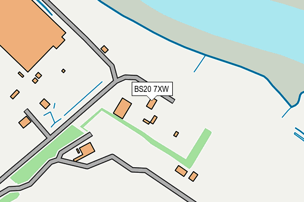
BS20 7XW is located in the Gordano Valley electoral ward, within the unitary authority of North Somerset and the English Parliamentary constituency of North Somerset. The Sub Integrated Care Board (ICB) Location is NHS Bristol, North Somerset and South Gloucestershire ICB - 15C and the police force is Avon and Somerset. This postcode has been in use since December 1997.


GetTheData
Source: OS OpenMap – Local (Ordnance Survey)
Source: OS VectorMap District (Ordnance Survey)
Licence: Open Government Licence (requires attribution)
| Easting | 350878 |
| Northing | 177470 |
| Latitude | 51.494026 |
| Longitude | -2.708966 |
GetTheData
Source: Open Postcode Geo
Licence: Open Government Licence
| Country | England |
| Postcode District | BS20 |
| ➜ BS20 open data dashboard ➜ See where BS20 is on a map | |
GetTheData
Source: Land Registry Price Paid Data
Licence: Open Government Licence
Elevation or altitude of BS20 7XW as distance above sea level:
| Metres | Feet | |
|---|---|---|
| Elevation | 10m | 33ft |
Elevation is measured from the approximate centre of the postcode, to the nearest point on an OS contour line from OS Terrain 50, which has contour spacing of ten vertical metres.
➜ How high above sea level am I? Find the elevation of your current position using your device's GPS.
GetTheData
Source: Open Postcode Elevation
Licence: Open Government Licence
| Ward | Gordano Valley |
| Constituency | North Somerset |
GetTheData
Source: ONS Postcode Database
Licence: Open Government Licence
| Avonmouth Station (Portview Road) | Avonmouth | 978m |
| Napier Road (Avonmouth Road) | Avonmouth | 1,039m |
| Mclaren Road | Avonmouth | 1,060m |
| Mclaren Road | Avonmouth | 1,077m |
| St Brendan's Way (Saint Andrews Road) | Avonmouth | 1,109m |
| Avonmouth Station | 1km |
| St Andrews Road Station | 2.3km |
| Shirehampton Station | 2.3km |
GetTheData
Source: NaPTAN
Licence: Open Government Licence
GetTheData
Source: ONS Postcode Database
Licence: Open Government Licence

➜ Get more ratings from the Food Standards Agency
GetTheData
Source: Food Standards Agency
Licence: FSA terms & conditions
| Last Collection | |||
|---|---|---|---|
| Location | Mon-Fri | Sat | Distance |
| Gloucester Road | 17:45 | 12:00 | 924m |
| Avonmouth Post Office | 18:30 | 12:45 | 1,110m |
| Avonmouth Road Post Office | 17:15 | 12:30 | 1,115m |
GetTheData
Source: Dracos
Licence: Creative Commons Attribution-ShareAlike
| Facility | Distance |
|---|---|
| Robin Cousins Sports Centre (Closed) Portway, Bristol Sports Hall, Health and Fitness Gym, Squash Courts | 1.5km |
| Avonmouth Football Club Avonmouth Road, Avonmouth, Bristol Grass Pitches | 1.5km |
| St George Easton In Gordano Fc Priory Road, Easton-in-gordano Grass Pitches | 1.9km |
GetTheData
Source: Active Places
Licence: Open Government Licence
| School | Phase of Education | Distance |
|---|---|---|
| Avonmouth Church of England Primary School and Nursery Catherine Street, Avonmouth, Bristol, BS11 9LG | Primary | 1.3km |
| Nova Primary School Barracks Lane, Shirehampton, Bristol, BS11 9NG | Primary | 1.9km |
| Shirehampton Primary School St Mary's Walk, Shirehampton, Bristol, BS11 9RR | Primary | 1.9km |
GetTheData
Source: Edubase
Licence: Open Government Licence
The below table lists the International Territorial Level (ITL) codes (formerly Nomenclature of Territorial Units for Statistics (NUTS) codes) and Local Administrative Units (LAU) codes for BS20 7XW:
| ITL 1 Code | Name |
|---|---|
| TLK | South West (England) |
| ITL 2 Code | Name |
| TLK1 | Gloucestershire, Wiltshire and Bath/Bristol area |
| ITL 3 Code | Name |
| TLK12 | Bath and North East Somerset, North Somerset and South Gloucestershire |
| LAU 1 Code | Name |
| E06000024 | North Somerset |
GetTheData
Source: ONS Postcode Directory
Licence: Open Government Licence
The below table lists the Census Output Area (OA), Lower Layer Super Output Area (LSOA), and Middle Layer Super Output Area (MSOA) for BS20 7XW:
| Code | Name | |
|---|---|---|
| OA | E00074592 | |
| LSOA | E01014767 | North Somerset 004B |
| MSOA | E02003068 | North Somerset 004 |
GetTheData
Source: ONS Postcode Directory
Licence: Open Government Licence
| BS20 0NH | Marsh Lane | 597m |
| BS11 9AQ | Gloucester Road | 874m |
| BS11 9AH | Clayton Street | 889m |
| BS11 9AD | Gloucester Road | 903m |
| BS11 9AJ | Napier Square | 935m |
| BS11 9AL | Queen Street | 936m |
| BS11 9AS | Meadow Street | 939m |
| BS11 9AA | Gloucester Road | 951m |
| BS11 9AR | Meadow Street | 960m |
| BS11 9JB | Portview Road | 970m |
GetTheData
Source: Open Postcode Geo; Land Registry Price Paid Data
Licence: Open Government Licence