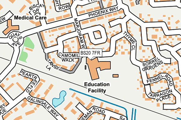
BS20 7FR is located in the Portishead East electoral ward, within the unitary authority of North Somerset and the English Parliamentary constituency of North Somerset. The Sub Integrated Care Board (ICB) Location is NHS Bristol, North Somerset and South Gloucestershire ICB - 15C and the police force is Avon and Somerset. This postcode has been in use since April 2009.


GetTheData
Source: OS OpenMap – Local (Ordnance Survey)
Source: OS VectorMap District (Ordnance Survey)
Licence: Open Government Licence (requires attribution)
| Easting | 347839 |
| Northing | 176335 |
| Latitude | 51.483548 |
| Longitude | -2.752568 |
GetTheData
Source: Open Postcode Geo
Licence: Open Government Licence
| Country | England |
| Postcode District | BS20 |
| ➜ BS20 open data dashboard ➜ See where BS20 is on a map ➜ Where is Portishead? | |
GetTheData
Source: Land Registry Price Paid Data
Licence: Open Government Licence
Elevation or altitude of BS20 7FR as distance above sea level:
| Metres | Feet | |
|---|---|---|
| Elevation | 10m | 33ft |
Elevation is measured from the approximate centre of the postcode, to the nearest point on an OS contour line from OS Terrain 50, which has contour spacing of ten vertical metres.
➜ How high above sea level am I? Find the elevation of your current position using your device's GPS.
GetTheData
Source: Open Postcode Elevation
Licence: Open Government Licence
| Ward | Portishead East |
| Constituency | North Somerset |
GetTheData
Source: ONS Postcode Database
Licence: Open Government Licence
| November 2023 | Burglary | On or near Tarragon Place | 207m |
| October 2023 | Anti-social behaviour | On or near Tarragon Place | 207m |
| August 2023 | Public order | On or near Camomile Walk | 140m |
| ➜ Get more crime data in our Crime section | |||
GetTheData
Source: data.police.uk
Licence: Open Government Licence
| Phoenix Way (Pheonix Way) | Portishead Dock | 247m |
| Phoenix Way (Pheonix Way) | Portishead Dock | 251m |
| Malin Parade (Pheonix Way) | Portishead Dock | 262m |
| Malin Parade (Pheonix Way) | Portishead Dock | 275m |
| Galingale Way (Quays Avenue) | Portishead Dock | 362m |
| Avonmouth Station | 4.1km |
| St Andrews Road Station | 5.1km |
GetTheData
Source: NaPTAN
Licence: Open Government Licence
GetTheData
Source: ONS Postcode Database
Licence: Open Government Licence


➜ Get more ratings from the Food Standards Agency
GetTheData
Source: Food Standards Agency
Licence: FSA terms & conditions
| Last Collection | |||
|---|---|---|---|
| Location | Mon-Fri | Sat | Distance |
| New Dock Road | 18:00 | 11:15 | 439m |
| Harbour Road | 16:30 | 11:00 | 459m |
| Portbury Hundred | 18:00 | 11:15 | 600m |
GetTheData
Source: Dracos
Licence: Creative Commons Attribution-ShareAlike
| Facility | Distance |
|---|---|
| The Fitness Hub (Closed) Harbour Road, Portishead, Bristol Health and Fitness Gym, Studio | 549m |
| The Hub Old Mill Road, Portishead, Bristol Health and Fitness Gym, Studio | 778m |
| Puregym (Portishead) Wyndham Way, Portishead, Bristol Health and Fitness Gym | 819m |
GetTheData
Source: Active Places
Licence: Open Government Licence
| School | Phase of Education | Distance |
|---|---|---|
| Trinity Anglican-Methodist Primary School Marjoram Way, Portishead, Bristol, BS20 7JF | Primary | 45m |
| Portishead Primary School Station Road, Portishead, BS20 7DB | Primary | 937m |
| St Peter's Church of England Primary School Hallett's Way, Portishead, BS20 6BT | Primary | 1km |
GetTheData
Source: Edubase
Licence: Open Government Licence
The below table lists the International Territorial Level (ITL) codes (formerly Nomenclature of Territorial Units for Statistics (NUTS) codes) and Local Administrative Units (LAU) codes for BS20 7FR:
| ITL 1 Code | Name |
|---|---|
| TLK | South West (England) |
| ITL 2 Code | Name |
| TLK1 | Gloucestershire, Wiltshire and Bath/Bristol area |
| ITL 3 Code | Name |
| TLK12 | Bath and North East Somerset, North Somerset and South Gloucestershire |
| LAU 1 Code | Name |
| E06000024 | North Somerset |
GetTheData
Source: ONS Postcode Directory
Licence: Open Government Licence
The below table lists the Census Output Area (OA), Lower Layer Super Output Area (LSOA), and Middle Layer Super Output Area (MSOA) for BS20 7FR:
| Code | Name | |
|---|---|---|
| OA | E00074721 | |
| LSOA | E01032678 | North Somerset 003E |
| MSOA | E02003067 | North Somerset 003 |
GetTheData
Source: ONS Postcode Directory
Licence: Open Government Licence
| BS20 7JR | Marjoram Way | 67m |
| BS20 7JS | Marjoram Way | 97m |
| BS20 7JT | Rosemary Crescent | 100m |
| BS20 7JF | Marjoram Way | 121m |
| BS20 7JP | Camomile Walk | 145m |
| BS20 7JU | Thyme Close | 145m |
| BS20 7JL | Tansy Lane | 163m |
| BS20 7FJ | Sorrel Gardens | 163m |
| BS20 7LW | Holmlea | 171m |
| BS20 7FH | Tarragon Place | 177m |
GetTheData
Source: Open Postcode Geo; Land Registry Price Paid Data
Licence: Open Government Licence