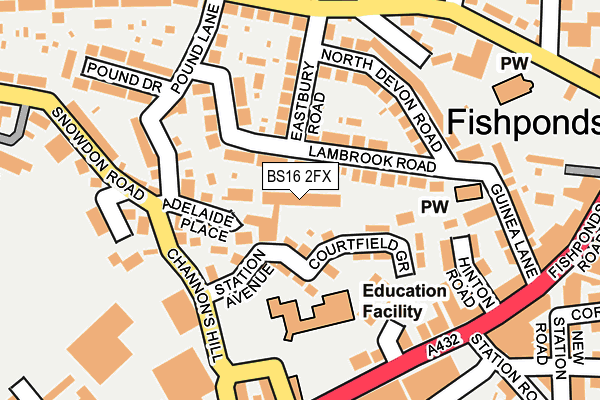
BS16 2FX is located in the Frome Vale electoral ward, within the unitary authority of Bristol, City of and the English Parliamentary constituency of Bristol East. The Sub Integrated Care Board (ICB) Location is NHS Bristol, North Somerset and South Gloucestershire ICB - 15C and the police force is Avon and Somerset. This postcode has been in use since December 2015.


GetTheData
Source: OS OpenMap – Local (Ordnance Survey)
Source: OS VectorMap District (Ordnance Survey)
Licence: Open Government Licence (requires attribution)
| Easting | 363037 |
| Northing | 175866 |
| Latitude | 51.480532 |
| Longitude | -2.533662 |
GetTheData
Source: Open Postcode Geo
Licence: Open Government Licence
| Country | England |
| Postcode District | BS16 |
➜ See where BS16 is on a map ➜ Where is Fishponds? | |
GetTheData
Source: Land Registry Price Paid Data
Licence: Open Government Licence
Elevation or altitude of BS16 2FX as distance above sea level:
| Metres | Feet | |
|---|---|---|
| Elevation | 50m | 164ft |
Elevation is measured from the approximate centre of the postcode, to the nearest point on an OS contour line from OS Terrain 50, which has contour spacing of ten vertical metres.
➜ How high above sea level am I? Find the elevation of your current position using your device's GPS.
GetTheData
Source: Open Postcode Elevation
Licence: Open Government Licence
| Ward | Frome Vale |
| Constituency | Bristol East |
GetTheData
Source: ONS Postcode Database
Licence: Open Government Licence
| Channons Hill | Fishponds | 175m |
| Channons Hill (Fishponds Road) | Fishponds | 180m |
| Channons Hill (Fishponds Road) | Fishponds | 192m |
| Snowdon Road | Fishponds | 216m |
| Eastbury Road (Manor Road) | Fishponds | 222m |
| Stapleton Road Station | 2.7km |
| Lawrence Hill Station | 3.3km |
| Filton Abbey Wood Station | 3.4km |
GetTheData
Source: NaPTAN
Licence: Open Government Licence
GetTheData
Source: ONS Postcode Database
Licence: Open Government Licence


➜ Get more ratings from the Food Standards Agency
GetTheData
Source: Food Standards Agency
Licence: FSA terms & conditions
| Last Collection | |||
|---|---|---|---|
| Location | Mon-Fri | Sat | Distance |
| Fishponds Old Post Office | 18:00 | 11:30 | 348m |
| Fishponds Old Post Office | 18:00 | 11:30 | 350m |
| Snowdon | 17:45 | 12:00 | 446m |
GetTheData
Source: Dracos
Licence: Creative Commons Attribution-ShareAlike
| Risk of BS16 2FX flooding from rivers and sea | Medium |
| ➜ BS16 2FX flood map | |
GetTheData
Source: Open Flood Risk by Postcode
Licence: Open Government Licence
The below table lists the International Territorial Level (ITL) codes (formerly Nomenclature of Territorial Units for Statistics (NUTS) codes) and Local Administrative Units (LAU) codes for BS16 2FX:
| ITL 1 Code | Name |
|---|---|
| TLK | South West (England) |
| ITL 2 Code | Name |
| TLK1 | Gloucestershire, Wiltshire and Bath/Bristol area |
| ITL 3 Code | Name |
| TLK11 | Bristol, City of |
| LAU 1 Code | Name |
| E06000023 | Bristol, City of |
GetTheData
Source: ONS Postcode Directory
Licence: Open Government Licence
The below table lists the Census Output Area (OA), Lower Layer Super Output Area (LSOA), and Middle Layer Super Output Area (MSOA) for BS16 2FX:
| Code | Name | |
|---|---|---|
| OA | E00073694 | |
| LSOA | E01014588 | Bristol 013A |
| MSOA | E02003024 | Bristol 013 |
GetTheData
Source: ONS Postcode Directory
Licence: Open Government Licence
| BS16 2EE | Adelaide Terrace | 28m |
| BS16 2ED | Adelaide Place | 39m |
| BS16 2DU | Station Avenue | 59m |
| BS16 2HA | Lambrook Road | 70m |
| BS16 2EZ | Lambrook Road | 102m |
| BS16 2EA | Channons Hill | 118m |
| BS16 2DS | Courtfield Grove | 123m |
| BS16 2EF | Pound Lane | 133m |
| BS16 2EY | Eastbury Road | 140m |
| BS16 2DY | Channons Hill | 160m |
GetTheData
Source: Open Postcode Geo; Land Registry Price Paid Data
Licence: Open Government Licence