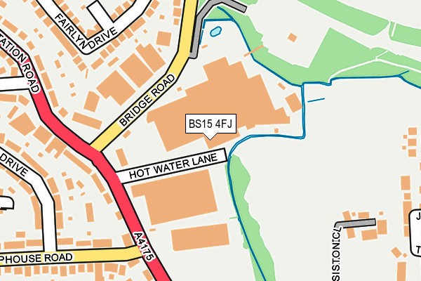
BS15 4FJ is located in the New Cheltenham electoral ward, within the unitary authority of South Gloucestershire and the English Parliamentary constituency of Kingswood. The Sub Integrated Care Board (ICB) Location is NHS Bristol, North Somerset and South Gloucestershire ICB - 15C and the police force is Avon and Somerset. This postcode has been in use since May 2008.


GetTheData
Source: OS OpenMap – Local (Ordnance Survey)
Source: OS VectorMap District (Ordnance Survey)
Licence: Open Government Licence (requires attribution)
| Easting | 366089 |
| Northing | 175205 |
| Latitude | 51.474782 |
| Longitude | -2.489650 |
GetTheData
Source: Open Postcode Geo
Licence: Open Government Licence
| Country | England |
| Postcode District | BS15 |
| ➜ BS15 open data dashboard ➜ See where BS15 is on a map ➜ Where is Kingswood? | |
GetTheData
Source: Land Registry Price Paid Data
Licence: Open Government Licence
Elevation or altitude of BS15 4FJ as distance above sea level:
| Metres | Feet | |
|---|---|---|
| Elevation | 60m | 197ft |
Elevation is measured from the approximate centre of the postcode, to the nearest point on an OS contour line from OS Terrain 50, which has contour spacing of ten vertical metres.
➜ How high above sea level am I? Find the elevation of your current position using your device's GPS.
GetTheData
Source: Open Postcode Elevation
Licence: Open Government Licence
| Ward | New Cheltenham |
| Constituency | Kingswood |
GetTheData
Source: ONS Postcode Database
Licence: Open Government Licence
| June 2022 | Vehicle crime | On or near Station Road | 200m |
| June 2022 | Violence and sexual offences | On or near Sports/Recreation Area | 320m |
| June 2022 | Violence and sexual offences | On or near Siston Close | 380m |
| ➜ Get more crime data in our Crime section | |||
GetTheData
Source: data.police.uk
Licence: Open Government Licence
| Bridge Road (Station Road) | Soundwell | 151m |
| Chiphouse Road (Station Road) | Soundwell | 171m |
| Chiphouse Road (Station Road) | New Cheltenham | 185m |
| Bridge Road (Station Road) | Soundwell | 212m |
| Middle Road | Soundwell | 426m |
| Bristol Parkway Station | 5.7km |
GetTheData
Source: NaPTAN
Licence: Open Government Licence
GetTheData
Source: ONS Postcode Database
Licence: Open Government Licence


➜ Get more ratings from the Food Standards Agency
GetTheData
Source: Food Standards Agency
Licence: FSA terms & conditions
| Last Collection | |||
|---|---|---|---|
| Location | Mon-Fri | Sat | Distance |
| Charnhill Drive | 17:15 | 08:00 | 524m |
| Memorial Road Post Office | 17:30 | 12:30 | 606m |
| Mangotsfield Road | 17:45 | 12:30 | 733m |
GetTheData
Source: Dracos
Licence: Creative Commons Attribution-ShareAlike
| Facility | Distance |
|---|---|
| Kings Forest Primary School Station Road, Kingswood, Bristol Grass Pitches | 322m |
| Mangotsfield School Rodway Hill, Mangotsfield, Bristol Athletics, Sports Hall, Artificial Grass Pitch, Grass Pitches, Studio, Outdoor Tennis Courts | 713m |
| Fisher Road Playing Field Fisher Road, Bristol Grass Pitches | 756m |
GetTheData
Source: Active Places
Licence: Open Government Licence
| School | Phase of Education | Distance |
|---|---|---|
| Kings' Forest Primary School Station Road, Kingswood, Bristol, BS15 4PQ | Primary | 231m |
| The Tynings Primary School Eastleigh Close, Staple Hill, BS16 4SG | Primary | 702m |
| Mangotsfield School Rodway Hill, Mangotsfield, Bristol, BS16 9LH | Secondary | 713m |
GetTheData
Source: Edubase
Licence: Open Government Licence
The below table lists the International Territorial Level (ITL) codes (formerly Nomenclature of Territorial Units for Statistics (NUTS) codes) and Local Administrative Units (LAU) codes for BS15 4FJ:
| ITL 1 Code | Name |
|---|---|
| TLK | South West (England) |
| ITL 2 Code | Name |
| TLK1 | Gloucestershire, Wiltshire and Bath/Bristol area |
| ITL 3 Code | Name |
| TLK12 | Bath and North East Somerset, North Somerset and South Gloucestershire |
| LAU 1 Code | Name |
| E06000025 | South Gloucestershire |
GetTheData
Source: ONS Postcode Directory
Licence: Open Government Licence
The below table lists the Census Output Area (OA), Lower Layer Super Output Area (LSOA), and Middle Layer Super Output Area (MSOA) for BS15 4FJ:
| Code | Name | |
|---|---|---|
| OA | E00075582 | |
| LSOA | E01014957 | South Gloucestershire 025C |
| MSOA | E02003114 | South Gloucestershire 025 |
GetTheData
Source: ONS Postcode Directory
Licence: Open Government Licence
| BS15 4FW | Bridge Road | 148m |
| BS15 4PN | Station Road | 169m |
| BS15 4PW | Bridge Road | 206m |
| BS15 4PQ | Station Road | 213m |
| BS15 4XX | Station Road | 221m |
| BS15 4PZ | Fairlyn Drive | 227m |
| BS15 4PL | Elmore | 239m |
| BS15 4PF | Siston Common | 241m |
| BS15 4PY | Fairlyn Drive | 243m |
| BS15 4XU | Station Road | 245m |
GetTheData
Source: Open Postcode Geo; Land Registry Price Paid Data
Licence: Open Government Licence