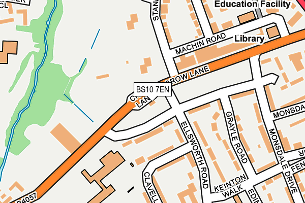
BS10 7EN is located in the Henbury and Brentry electoral ward, within the unitary authority of Bristol, City of and the English Parliamentary constituency of Bristol North West. The Sub Integrated Care Board (ICB) Location is NHS Bristol, North Somerset and South Gloucestershire ICB - 15C and the police force is Avon and Somerset. This postcode has been in use since February 2012.


GetTheData
Source: OS OpenMap – Local (Ordnance Survey)
Source: OS VectorMap District (Ordnance Survey)
Licence: Open Government Licence (requires attribution)
| Easting | 356869 |
| Northing | 179019 |
| Latitude | 51.508443 |
| Longitude | -2.622864 |
GetTheData
Source: Open Postcode Geo
Licence: Open Government Licence
| Country | England |
| Postcode District | BS10 |
| ➜ BS10 open data dashboard ➜ See where BS10 is on a map ➜ Where is Bristol? | |
GetTheData
Source: Land Registry Price Paid Data
Licence: Open Government Licence
Elevation or altitude of BS10 7EN as distance above sea level:
| Metres | Feet | |
|---|---|---|
| Elevation | 40m | 131ft |
Elevation is measured from the approximate centre of the postcode, to the nearest point on an OS contour line from OS Terrain 50, which has contour spacing of ten vertical metres.
➜ How high above sea level am I? Find the elevation of your current position using your device's GPS.
GetTheData
Source: Open Postcode Elevation
Licence: Open Government Licence
| Ward | Henbury And Brentry |
| Constituency | Bristol North West |
GetTheData
Source: ONS Postcode Database
Licence: Open Government Licence
| January 2024 | Criminal damage and arson | On or near Ellsworth Road | 115m |
| January 2024 | Criminal damage and arson | On or near Ellsworth Road | 115m |
| January 2024 | Violence and sexual offences | On or near Ellsworth Road | 115m |
| ➜ Get more crime data in our Crime section | |||
GetTheData
Source: data.police.uk
Licence: Open Government Licence
| Crow Lane Lay-by (Crow Lane) | Henbury | 10m |
| Crow Lane Lay-by (Crow Lane) | Henbury | 35m |
| Brentry Roundabout (Crow Lane) | Brentry | 252m |
| Brentry Roundabout (Crow Lane) | Brentry | 256m |
| The Salutation (Crow Lane) | Henbury | 342m |
| Sea Mills Station | 3.7km |
| Filton Abbey Wood Station | 4.2km |
| Patchway Station | 4.6km |
GetTheData
Source: NaPTAN
Licence: Open Government Licence
GetTheData
Source: ONS Postcode Database
Licence: Open Government Licence


➜ Get more ratings from the Food Standards Agency
GetTheData
Source: Food Standards Agency
Licence: FSA terms & conditions
| Last Collection | |||
|---|---|---|---|
| Location | Mon-Fri | Sat | Distance |
| Standfast Road | 16:30 | 10:45 | 51m |
| Satchfield Crescent | 16:30 | 10:45 | 269m |
| Brentry Post Office | 17:00 | 10:45 | 394m |
GetTheData
Source: Dracos
Licence: Creative Commons Attribution-ShareAlike
| Facility | Distance |
|---|---|
| Blaise Primary School Clavell Road, Bristol Grass Pitches | 153m |
| Henbury Swimming Pool (Closed) Crow Lane, Henbury, Bristol Swimming Pool | 199m |
| Henbury Old Boys Football Club Lorain Walk, Bristol Grass Pitches | 408m |
GetTheData
Source: Active Places
Licence: Open Government Licence
| School | Phase of Education | Distance |
|---|---|---|
| Blaise Primary and Nursery School Clavell Road, Henbury, Bristol, BS10 7EJ | Primary | 153m |
| Henbury Court Primary Academy Trevelyan Walk, Henbury, Bristol, BS10 7NY | Primary | 372m |
| North Star 82° Rectory Gardens, Henbury, Bristol, BS10 7AH | Not applicable | 539m |
GetTheData
Source: Edubase
Licence: Open Government Licence
The below table lists the International Territorial Level (ITL) codes (formerly Nomenclature of Territorial Units for Statistics (NUTS) codes) and Local Administrative Units (LAU) codes for BS10 7EN:
| ITL 1 Code | Name |
|---|---|
| TLK | South West (England) |
| ITL 2 Code | Name |
| TLK1 | Gloucestershire, Wiltshire and Bath/Bristol area |
| ITL 3 Code | Name |
| TLK11 | Bristol, City of |
| LAU 1 Code | Name |
| E06000023 | Bristol, City of |
GetTheData
Source: ONS Postcode Directory
Licence: Open Government Licence
The below table lists the Census Output Area (OA), Lower Layer Super Output Area (LSOA), and Middle Layer Super Output Area (MSOA) for BS10 7EN:
| Code | Name | |
|---|---|---|
| OA | E00073758 | |
| LSOA | E01032517 | Bristol 001H |
| MSOA | E02003012 | Bristol 001 |
GetTheData
Source: ONS Postcode Directory
Licence: Open Government Licence
| BS10 7EL | Crow Lane | 62m |
| BS10 7HL | Standfast Road | 63m |
| BS10 7HN | Standfast Road | 63m |
| BS10 7DS | Crow Lane | 102m |
| BS10 7EH | Ellsworth Road | 131m |
| BS10 7EQ | Ellsworth Road | 150m |
| BS10 7HR | Standfast Road | 156m |
| BS10 7HS | Standfast Road | 156m |
| BS10 7EJ | Clavell Road | 167m |
| BS10 7EG | Grayle Road | 172m |
GetTheData
Source: Open Postcode Geo; Land Registry Price Paid Data
Licence: Open Government Licence