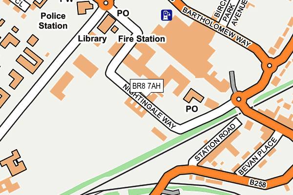
BR8 7AH is located in the Swanley St Mary's electoral ward, within the local authority district of Sevenoaks and the English Parliamentary constituency of Sevenoaks. The Sub Integrated Care Board (ICB) Location is NHS Kent and Medway ICB - 91Q and the police force is Kent. This postcode has been in use since January 1980.


GetTheData
Source: OS OpenMap – Local (Ordnance Survey)
Source: OS VectorMap District (Ordnance Survey)
Licence: Open Government Licence (requires attribution)
| Easting | 551322 |
| Northing | 168557 |
| Latitude | 51.395873 |
| Longitude | 0.173742 |
GetTheData
Source: Open Postcode Geo
Licence: Open Government Licence
| Country | England |
| Postcode District | BR8 |
| ➜ BR8 open data dashboard ➜ See where BR8 is on a map ➜ Where is Swanley? | |
GetTheData
Source: Land Registry Price Paid Data
Licence: Open Government Licence
Elevation or altitude of BR8 7AH as distance above sea level:
| Metres | Feet | |
|---|---|---|
| Elevation | 80m | 262ft |
Elevation is measured from the approximate centre of the postcode, to the nearest point on an OS contour line from OS Terrain 50, which has contour spacing of ten vertical metres.
➜ How high above sea level am I? Find the elevation of your current position using your device's GPS.
GetTheData
Source: Open Postcode Elevation
Licence: Open Government Licence
| Ward | Swanley St Mary's |
| Constituency | Sevenoaks |
GetTheData
Source: ONS Postcode Database
Licence: Open Government Licence
| January 2024 | Criminal damage and arson | On or near Station Road | 166m |
| January 2024 | Other theft | On or near Station Road | 166m |
| January 2024 | Other theft | On or near Station Road | 166m |
| ➜ Get more crime data in our Crime section | |||
GetTheData
Source: data.police.uk
Licence: Open Government Licence
| Orchards Academy (St Mary's Road) | Swanley | 183m |
| Bartholomew Way Asda (Bartholomew Way) | Swanley | 192m |
| Orchards Academy (St Mary's Road) | Swanley | 208m |
| Bartholomew Way Asda (Bartholomew Way) | Swanley | 215m |
| High Street | Swanley | 222m |
| Swanley Station | 0.4km |
| Eynsford Station | 4.3km |
| Farningham Road Station | 4.3km |
GetTheData
Source: NaPTAN
Licence: Open Government Licence
GetTheData
Source: ONS Postcode Database
Licence: Open Government Licence

➜ Get more ratings from the Food Standards Agency
GetTheData
Source: Food Standards Agency
Licence: FSA terms & conditions
| Last Collection | |||
|---|---|---|---|
| Location | Mon-Fri | Sat | Distance |
| Asda - Swanley Centre | 16:30 | 12:00 | 108m |
| Swanley P.o. | 18:30 | 12:00 | 120m |
| White Oaks London Road | 18:00 | 12:00 | 282m |
GetTheData
Source: Dracos
Licence: Creative Commons Attribution-ShareAlike
| Facility | Distance |
|---|---|
| St. Marys Recreational Ground St Marys Road, Swanley Grass Pitches, Outdoor Tennis Courts | 140m |
| Orchards Academy St. Marys Road, Swanley Sports Hall, Artificial Grass Pitch, Studio | 235m |
| St. Marys C Of E Primary School St. Marys Road, Swanley Grass Pitches | 310m |
GetTheData
Source: Active Places
Licence: Open Government Licence
| School | Phase of Education | Distance |
|---|---|---|
| Orchards Academy St Mary's Road, Swanley, BR8 7TE | Secondary | 271m |
| SupaJam Education In Music and Media St Marys Road, Swanley, BR8 7TE | Not applicable | 271m |
| St Bartholomew's Catholic Primary School, Swanley Sycamore Drive, Swanley, BR8 7AY | Primary | 322m |
GetTheData
Source: Edubase
Licence: Open Government Licence
The below table lists the International Territorial Level (ITL) codes (formerly Nomenclature of Territorial Units for Statistics (NUTS) codes) and Local Administrative Units (LAU) codes for BR8 7AH:
| ITL 1 Code | Name |
|---|---|
| TLJ | South East (England) |
| ITL 2 Code | Name |
| TLJ4 | Kent |
| ITL 3 Code | Name |
| TLJ46 | West Kent |
| LAU 1 Code | Name |
| E07000111 | Sevenoaks |
GetTheData
Source: ONS Postcode Directory
Licence: Open Government Licence
The below table lists the Census Output Area (OA), Lower Layer Super Output Area (LSOA), and Middle Layer Super Output Area (MSOA) for BR8 7AH:
| Code | Name | |
|---|---|---|
| OA | E00124243 | |
| LSOA | E01024477 | Sevenoaks 002B |
| MSOA | E02005088 | Sevenoaks 002 |
GetTheData
Source: ONS Postcode Directory
Licence: Open Government Licence
| BR8 7UD | Nightingale Way | 31m |
| BR8 7AB | London Road | 129m |
| BR8 8ES | Station Road | 178m |
| BR8 8EY | Goldsel Road | 232m |
| BR8 7AU | Birchwood Park Avenue | 243m |
| BR8 8BE | High Street | 249m |
| BR8 8BH | Bevan Place | 250m |
| BR8 7AT | Birchwood Park Avenue | 258m |
| BR8 7AG | White Oak Square | 276m |
| BR8 8DU | Goldsel Road | 279m |
GetTheData
Source: Open Postcode Geo; Land Registry Price Paid Data
Licence: Open Government Licence