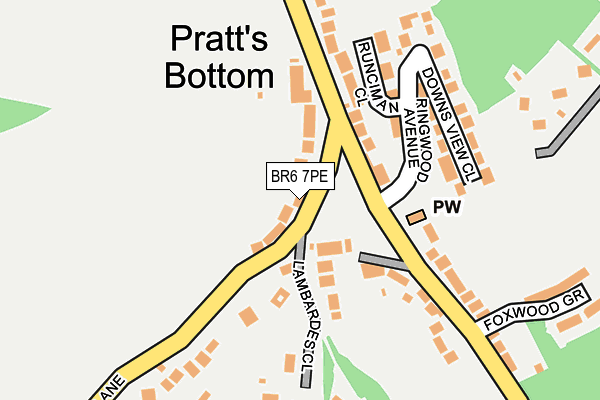
BR6 7PE lies on Norsted Lane in Pratts Bottom, Orpington. BR6 7PE is located in the Darwin electoral ward, within the London borough of Bromley and the English Parliamentary constituency of Orpington. The Sub Integrated Care Board (ICB) Location is NHS South East London ICB - 72Q and the police force is Metropolitan Police. This postcode has been in use since January 1980.


GetTheData
Source: OS OpenMap – Local (Ordnance Survey)
Source: OS VectorMap District (Ordnance Survey)
Licence: Open Government Licence (requires attribution)
| Easting | 547131 |
| Northing | 162161 |
| Latitude | 51.339503 |
| Longitude | 0.110900 |
GetTheData
Source: Open Postcode Geo
Licence: Open Government Licence
| Street | Norsted Lane |
| Locality | Pratts Bottom |
| Town/City | Orpington |
| Country | England |
| Postcode District | BR6 |
| ➜ BR6 open data dashboard ➜ See where BR6 is on a map ➜ Where is Pratt's Bottom? | |
GetTheData
Source: Land Registry Price Paid Data
Licence: Open Government Licence
Elevation or altitude of BR6 7PE as distance above sea level:
| Metres | Feet | |
|---|---|---|
| Elevation | 110m | 361ft |
Elevation is measured from the approximate centre of the postcode, to the nearest point on an OS contour line from OS Terrain 50, which has contour spacing of ten vertical metres.
➜ How high above sea level am I? Find the elevation of your current position using your device's GPS.
GetTheData
Source: Open Postcode Elevation
Licence: Open Government Licence
| Ward | Darwin |
| Constituency | Orpington |
GetTheData
Source: ONS Postcode Database
Licence: Open Government Licence
| June 2022 | Anti-social behaviour | On or near Rushmore Hill | 360m |
| June 2022 | Anti-social behaviour | On or near Rushmore Hill | 360m |
| June 2022 | Anti-social behaviour | On or near Rushmore Hill | 360m |
| ➜ Get more crime data in our Crime section | |||
GetTheData
Source: data.police.uk
Licence: Open Government Licence
| Pratts Bottom The Green | Pratt's Bottom | 65m |
| Pratts Bottom The Green | Pratt's Bottom | 72m |
| Pratts Bottom Primary School | Pratt's Bottom | 305m |
| Pratts Bottom Primary School | Pratt's Bottom | 325m |
| Pratts Bottom Orchard Road | Pratt's Bottom | 364m |
| Knockholt Station | 1.6km |
| Chelsfield Station | 1.9km |
| Orpington Station | 4.1km |
GetTheData
Source: NaPTAN
Licence: Open Government Licence
| Percentage of properties with Next Generation Access | 100.0% |
| Percentage of properties with Superfast Broadband | 100.0% |
| Percentage of properties with Ultrafast Broadband | 0.0% |
| Percentage of properties with Full Fibre Broadband | 0.0% |
Superfast Broadband is between 30Mbps and 300Mbps
Ultrafast Broadband is > 300Mbps
| Percentage of properties unable to receive 2Mbps | 0.0% |
| Percentage of properties unable to receive 5Mbps | 0.0% |
| Percentage of properties unable to receive 10Mbps | 0.0% |
| Percentage of properties unable to receive 30Mbps | 0.0% |
GetTheData
Source: Ofcom
Licence: Ofcom Terms of Use (requires attribution)
GetTheData
Source: ONS Postcode Database
Licence: Open Government Licence


➜ Get more ratings from the Food Standards Agency
GetTheData
Source: Food Standards Agency
Licence: FSA terms & conditions
| Last Collection | |||
|---|---|---|---|
| Location | Mon-Fri | Sat | Distance |
| Pratts Bottom Tso | 18:00 | 12:00 | 106m |
| Stonehouse Lane | 16:45 | 09:00 | 743m |
| The Hillside | 17:00 | 12:00 | 788m |
GetTheData
Source: Dracos
Licence: Creative Commons Attribution-ShareAlike
| Facility | Distance |
|---|---|
| Broke Hill Golf Club (Closed) Sevenoaks Road, Halstead, Sevenoaks Golf | 1.5km |
| Chelsfield Lakes Golf Centre Court Road, Orpington Golf | 1.6km |
| Halstead Recreation Ground Station Road, Halstead Grass Pitches | 1.9km |
GetTheData
Source: Active Places
Licence: Open Government Licence
| School | Phase of Education | Distance |
|---|---|---|
| Pratts Bottom Primary School Hookwood Road, Pratts Bottom, Orpington, BR6 7NX | Primary | 358m |
| Green Street Green Primary School Vine Road, Orpington, BR6 6DT | Primary | 2km |
| Halstead Community Primary School Otford Lane, Halstead, Sevenoaks, TN14 7EA | Primary | 2.1km |
GetTheData
Source: Edubase
Licence: Open Government Licence
The below table lists the International Territorial Level (ITL) codes (formerly Nomenclature of Territorial Units for Statistics (NUTS) codes) and Local Administrative Units (LAU) codes for BR6 7PE:
| ITL 1 Code | Name |
|---|---|
| TLI | London |
| ITL 2 Code | Name |
| TLI6 | Outer London - South |
| ITL 3 Code | Name |
| TLI61 | Bromley |
| LAU 1 Code | Name |
| E09000006 | Bromley |
GetTheData
Source: ONS Postcode Directory
Licence: Open Government Licence
The below table lists the Census Output Area (OA), Lower Layer Super Output Area (LSOA), and Middle Layer Super Output Area (MSOA) for BR6 7PE:
| Code | Name | |
|---|---|---|
| OA | E00003308 | |
| LSOA | E01000680 | Bromley 037A |
| MSOA | E02000163 | Bromley 037 |
GetTheData
Source: ONS Postcode Directory
Licence: Open Government Licence
| BR6 7PD | Norsted Lane | 36m |
| BR6 7PG | Norsted Lane | 58m |
| BR6 7NQ | Rushmore Hill | 93m |
| BR6 7NL | The Green | 96m |
| BR6 7NJ | Charmwood Villas | 100m |
| BR6 7PF | Norsted Lane | 106m |
| BR6 7NE | Mount Pleasant Cottages | 117m |
| BR6 7NN | Rushmore Hill | 123m |
| BR6 7PQ | Norsted Lane | 126m |
| BR6 7NW | Nightingale Cottages | 155m |
GetTheData
Source: Open Postcode Geo; Land Registry Price Paid Data
Licence: Open Government Licence