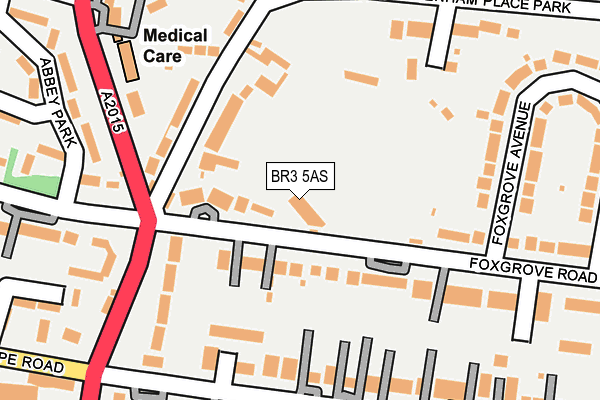
BR3 5AS is located in the Beckenham Town & Copers Cope electoral ward, within the London borough of Bromley and the English Parliamentary constituency of Beckenham. The Sub Integrated Care Board (ICB) Location is NHS South East London ICB - 72Q and the police force is Metropolitan Police. This postcode has been in use since December 1995.


GetTheData
Source: OS OpenMap – Local (Ordnance Survey)
Source: OS VectorMap District (Ordnance Survey)
Licence: Open Government Licence (requires attribution)
| Easting | 537656 |
| Northing | 170116 |
| Latitude | 51.413360 |
| Longitude | -0.021959 |
GetTheData
Source: Open Postcode Geo
Licence: Open Government Licence
| Country | England |
| Postcode District | BR3 |
| ➜ BR3 open data dashboard ➜ See where BR3 is on a map ➜ Where is Beckenham? | |
GetTheData
Source: Land Registry Price Paid Data
Licence: Open Government Licence
Elevation or altitude of BR3 5AS as distance above sea level:
| Metres | Feet | |
|---|---|---|
| Elevation | 40m | 131ft |
Elevation is measured from the approximate centre of the postcode, to the nearest point on an OS contour line from OS Terrain 50, which has contour spacing of ten vertical metres.
➜ How high above sea level am I? Find the elevation of your current position using your device's GPS.
GetTheData
Source: Open Postcode Elevation
Licence: Open Government Licence
| Ward | Beckenham Town & Copers Cope |
| Constituency | Beckenham |
GetTheData
Source: ONS Postcode Database
Licence: Open Government Licence
| January 2024 | Shoplifting | On or near Parking Area | 427m |
| January 2024 | Other theft | On or near The Mews | 465m |
| January 2024 | Criminal damage and arson | On or near The Mews | 465m |
| ➜ Get more crime data in our Crime section | |||
GetTheData
Source: data.police.uk
Licence: Open Government Licence
| Beckenham Cricket Club (Foxgrove Road) | Beckenham | 53m |
| Beckenham Cricket Club (Foxgrove Road) | Beckenham | 91m |
| Copers Cope Road (Southend Road) | Beckenham | 216m |
| Copers Cope Road (Southend Road) | Beckenham | 224m |
| Brackley Road | New Beckenham | 339m |
| Beckenham Junction Tram Stop (Rectory Road) | Beckenham | 426m |
| Beckenham Road Tram Stop (Beckenham Road) | Penge & Sydenham | 1,553m |
| Beckenham Junction Station | 0.4km |
| New Beckenham Station | 1km |
| Ravensbourne Station | 1km |
GetTheData
Source: NaPTAN
Licence: Open Government Licence
GetTheData
Source: ONS Postcode Database
Licence: Open Government Licence


➜ Get more ratings from the Food Standards Agency
GetTheData
Source: Food Standards Agency
Licence: FSA terms & conditions
| Last Collection | |||
|---|---|---|---|
| Location | Mon-Fri | Sat | Distance |
| Foxgrove Road (26) | 18:00 | 12:00 | 205m |
| The Park (Baytrees) | 18:00 | 12:00 | 226m |
| Copers Cope Road (2) | 18:15 | 12:00 | 284m |
GetTheData
Source: Dracos
Licence: Creative Commons Attribution-ShareAlike
| Facility | Distance |
|---|---|
| Beckenham Sports Club Foxgrove Road, Beckenham Grass Pitches, Squash Courts, Outdoor Tennis Courts | 97m |
| Beckenham Public Hall Bromley Road, Bromley Road, Beckenham Sports Hall | 559m |
| Beckenham Place Park Golf Course (Closed) Beckenham Place Park, Beckenham Golf | 630m |
GetTheData
Source: Active Places
Licence: Open Government Licence
| School | Phase of Education | Distance |
|---|---|---|
| St Mary's Catholic Primary School Westgate Road, Beckenham, BR3 5DE | Primary | 442m |
| Worsley Bridge Primary School Worsley Bridge Primary School, Brackley Road, Beckenham, BR3 1RF | Primary | 456m |
| Harris Primary Academy Beckenham Green St George's Road, Beckenham, BR3 5JG | Primary | 509m |
GetTheData
Source: Edubase
Licence: Open Government Licence
The below table lists the International Territorial Level (ITL) codes (formerly Nomenclature of Territorial Units for Statistics (NUTS) codes) and Local Administrative Units (LAU) codes for BR3 5AS:
| ITL 1 Code | Name |
|---|---|
| TLI | London |
| ITL 2 Code | Name |
| TLI6 | Outer London - South |
| ITL 3 Code | Name |
| TLI61 | Bromley |
| LAU 1 Code | Name |
| E09000006 | Bromley |
GetTheData
Source: ONS Postcode Directory
Licence: Open Government Licence
The below table lists the Census Output Area (OA), Lower Layer Super Output Area (LSOA), and Middle Layer Super Output Area (MSOA) for BR3 5AS:
| Code | Name | |
|---|---|---|
| OA | E00003470 | |
| LSOA | E01000712 | Bromley 012A |
| MSOA | E02000138 | Bromley 012 |
GetTheData
Source: ONS Postcode Directory
Licence: Open Government Licence
| BR3 5AR | Foxgrove Road | 36m |
| BR3 5AT | Foxgrove Road | 75m |
| BR3 5AU | Foxgrove Road | 79m |
| BR3 5AX | Foxgrove Road | 118m |
| BR3 5BN | Beckenham Place Park | 122m |
| BR3 5YR | Redroofs Close | 149m |
| BR3 5BW | Maywood Close | 150m |
| BR3 1SD | Southend Road | 175m |
| BR3 5DQ | The Avenue | 178m |
| BR3 5XU | Foxgrove Road | 188m |
GetTheData
Source: Open Postcode Geo; Land Registry Price Paid Data
Licence: Open Government Licence