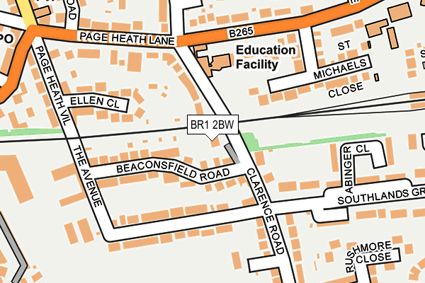
BR1 2BW lies on Clarence Road in Bromley. BR1 2BW is located in the Bickley & Sundridge electoral ward, within the London borough of Bromley and the English Parliamentary constituency of Bromley and Chislehurst. The Sub Integrated Care Board (ICB) Location is NHS South East London ICB - 72Q and the police force is Metropolitan Police. This postcode has been in use since January 1980.


GetTheData
Source: OS OpenMap – Local (Ordnance Survey)
Source: OS VectorMap District (Ordnance Survey)
Licence: Open Government Licence (requires attribution)
| Easting | 541973 |
| Northing | 168699 |
| Latitude | 51.399564 |
| Longitude | 0.039509 |
GetTheData
Source: Open Postcode Geo
Licence: Open Government Licence
| Street | Clarence Road |
| Town/City | Bromley |
| Country | England |
| Postcode District | BR1 |
| ➜ BR1 open data dashboard ➜ See where BR1 is on a map ➜ Where is London? | |
GetTheData
Source: Land Registry Price Paid Data
Licence: Open Government Licence
Elevation or altitude of BR1 2BW as distance above sea level:
| Metres | Feet | |
|---|---|---|
| Elevation | 60m | 197ft |
Elevation is measured from the approximate centre of the postcode, to the nearest point on an OS contour line from OS Terrain 50, which has contour spacing of ten vertical metres.
➜ How high above sea level am I? Find the elevation of your current position using your device's GPS.
GetTheData
Source: Open Postcode Elevation
Licence: Open Government Licence
| Ward | Bickley & Sundridge |
| Constituency | Bromley And Chislehurst |
GetTheData
Source: ONS Postcode Database
Licence: Open Government Licence
| July 2023 | Violence and sexual offences | On or near Clarence Road | 122m |
| January 2023 | Burglary | On or near Clarence Road | 122m |
| October 2022 | Vehicle crime | On or near Clarence Road | 122m |
| ➜ Clarence Road crime map and outcomes | |||
GetTheData
Source: data.police.uk
Licence: Open Government Licence
| Clarence Road | Bickley | 153m |
| Clarence Road | Bickley | 176m |
| The Avenue Beaconsfield Road | Bickley | 179m |
| The Avenue Beaconsfield Road | Bickley | 187m |
| Tylney Road | Widmore | 268m |
| Bickley Station | 0.4km |
| Chislehurst Station | 1.4km |
| Bromley South Station | 1.5km |
GetTheData
Source: NaPTAN
Licence: Open Government Licence
| Percentage of properties with Next Generation Access | 100.0% |
| Percentage of properties with Superfast Broadband | 100.0% |
| Percentage of properties with Ultrafast Broadband | 0.0% |
| Percentage of properties with Full Fibre Broadband | 0.0% |
Superfast Broadband is between 30Mbps and 300Mbps
Ultrafast Broadband is > 300Mbps
| Percentage of properties unable to receive 2Mbps | 0.0% |
| Percentage of properties unable to receive 5Mbps | 0.0% |
| Percentage of properties unable to receive 10Mbps | 0.0% |
| Percentage of properties unable to receive 30Mbps | 0.0% |
GetTheData
Source: Ofcom
Licence: Ofcom Terms of Use (requires attribution)
GetTheData
Source: ONS Postcode Database
Licence: Open Government Licence


➜ Get more ratings from the Food Standards Agency
GetTheData
Source: Food Standards Agency
Licence: FSA terms & conditions
| Last Collection | |||
|---|---|---|---|
| Location | Mon-Fri | Sat | Distance |
| The Avenue Bickley | 18:30 | 12:00 | 118m |
| Bird In Hand Lane (1) | 18:30 | 12:00 | 165m |
| Page Heath Villas (Opp' 20) | 18:30 | 12:00 | 287m |
GetTheData
Source: Dracos
Licence: Creative Commons Attribution-ShareAlike
| Facility | Distance |
|---|---|
| Virgin Active (Bromley) Baths Road, Bromley Swimming Pool, Health and Fitness Gym, Studio | 285m |
| Bickley Park School Page Heath Lane, Bromley Sports Hall, Swimming Pool, Outdoor Tennis Courts | 361m |
| Whitehall Recreation Ground (Bromley) Southlands Road, Bromley Grass Pitches | 515m |
GetTheData
Source: Active Places
Licence: Open Government Licence
| School | Phase of Education | Distance |
|---|---|---|
| Bickley Park School 24 Page Heath Lane, Bickley, Bromley, BR1 2DS | Not applicable | 361m |
| St George's, Bickley, Church of England Primary School Tylney Road, Bromley, BR1 2RL | Primary | 527m |
| Bullers Wood School for Boys Chislehurst Road, Bromley, BR1 2NW | Secondary | 536m |
GetTheData
Source: Edubase
Licence: Open Government Licence
The below table lists the International Territorial Level (ITL) codes (formerly Nomenclature of Territorial Units for Statistics (NUTS) codes) and Local Administrative Units (LAU) codes for BR1 2BW:
| ITL 1 Code | Name |
|---|---|
| TLI | London |
| ITL 2 Code | Name |
| TLI6 | Outer London - South |
| ITL 3 Code | Name |
| TLI61 | Bromley |
| LAU 1 Code | Name |
| E09000006 | Bromley |
GetTheData
Source: ONS Postcode Directory
Licence: Open Government Licence
The below table lists the Census Output Area (OA), Lower Layer Super Output Area (LSOA), and Middle Layer Super Output Area (MSOA) for BR1 2BW:
| Code | Name | |
|---|---|---|
| OA | E00003147 | |
| LSOA | E01000648 | Bromley 016C |
| MSOA | E02000142 | Bromley 016 |
GetTheData
Source: ONS Postcode Directory
Licence: Open Government Licence
| BR1 2BP | Beaconsfield Road | 88m |
| BR1 2BL | Beaconsfield Road | 94m |
| BR1 2BN | Clarence Road | 102m |
| BR1 2DS | Page Heath Lane | 112m |
| BR1 2DU | Beresford Drive | 114m |
| BR1 2BY | Southlands Grove | 121m |
| BR1 2BT | The Avenue | 122m |
| BR1 2TX | The Avenue | 126m |
| BR1 2BZ | Southlands Grove | 149m |
| BR1 2DT | Page Heath Lane | 150m |
GetTheData
Source: Open Postcode Geo; Land Registry Price Paid Data
Licence: Open Government Licence