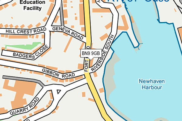
BN9 9GB is located in the Newhaven South electoral ward, within the local authority district of Lewes and the English Parliamentary constituency of Lewes. The Sub Integrated Care Board (ICB) Location is NHS Sussex ICB - 97R and the police force is Sussex. This postcode has been in use since March 2007.


GetTheData
Source: OS OpenMap – Local (Ordnance Survey)
Source: OS VectorMap District (Ordnance Survey)
Licence: Open Government Licence (requires attribution)
| Easting | 544725 |
| Northing | 100648 |
| Latitude | 50.787346 |
| Longitude | 0.051793 |
GetTheData
Source: Open Postcode Geo
Licence: Open Government Licence
| Country | England |
| Postcode District | BN9 |
➜ See where BN9 is on a map ➜ Where is Newhaven? | |
GetTheData
Source: Land Registry Price Paid Data
Licence: Open Government Licence
Elevation or altitude of BN9 9GB as distance above sea level:
| Metres | Feet | |
|---|---|---|
| Elevation | 10m | 33ft |
Elevation is measured from the approximate centre of the postcode, to the nearest point on an OS contour line from OS Terrain 50, which has contour spacing of ten vertical metres.
➜ How high above sea level am I? Find the elevation of your current position using your device's GPS.
GetTheData
Source: Open Postcode Elevation
Licence: Open Government Licence
| Ward | Newhaven South |
| Constituency | Lewes |
GetTheData
Source: ONS Postcode Database
Licence: Open Government Licence
| Gibbon Road Bottom (Gibbon Road) | Newhaven | 54m |
| Court Farm Road (Fort Road) | Newhaven | 57m |
| Fort Road | Newhaven | 281m |
| Newhaven Harbour Railway Station (Transit Road) | Newhaven | 393m |
| Second Avenue | Newhaven | 416m |
| Newhaven Harbour Station | 0.4km |
| Newhaven Town Station | 0.9km |
| Bishopstone Station | 2.3km |
GetTheData
Source: NaPTAN
Licence: Open Government Licence
GetTheData
Source: ONS Postcode Database
Licence: Open Government Licence


➜ Get more ratings from the Food Standards Agency
GetTheData
Source: Food Standards Agency
Licence: FSA terms & conditions
| Last Collection | |||
|---|---|---|---|
| Location | Mon-Fri | Sat | Distance |
| Fort Road | 17:15 | 12:00 | 61m |
| Hillcrest Road | 17:30 | 12:00 | 218m |
| Western Road | 17:30 | 12:00 | 362m |
GetTheData
Source: Dracos
Licence: Creative Commons Attribution-ShareAlike
| Risk of BN9 9GB flooding from rivers and sea | Low |
| ➜ BN9 9GB flood map | |
GetTheData
Source: Open Flood Risk by Postcode
Licence: Open Government Licence
The below table lists the International Territorial Level (ITL) codes (formerly Nomenclature of Territorial Units for Statistics (NUTS) codes) and Local Administrative Units (LAU) codes for BN9 9GB:
| ITL 1 Code | Name |
|---|---|
| TLJ | South East (England) |
| ITL 2 Code | Name |
| TLJ2 | Surrey, East and West Sussex |
| ITL 3 Code | Name |
| TLJ22 | East Sussex CC |
| LAU 1 Code | Name |
| E07000063 | Lewes |
GetTheData
Source: ONS Postcode Directory
Licence: Open Government Licence
The below table lists the Census Output Area (OA), Lower Layer Super Output Area (LSOA), and Middle Layer Super Output Area (MSOA) for BN9 9GB:
| Code | Name | |
|---|---|---|
| OA | E00106887 | |
| LSOA | E01021048 | Lewes 008D |
| MSOA | E02004386 | Lewes 008 |
GetTheData
Source: ONS Postcode Directory
Licence: Open Government Licence
| BN9 9GD | West Quay | 0m |
| BN9 9EL | Holmstreau Villas | 40m |
| BN9 9EN | Gibbon Road | 70m |
| BN9 9GE | West Quay | 89m |
| BN9 9EH | Old Coastguard Cottages | 94m |
| BN9 9EW | Gibbon Road | 112m |
| BN9 9GF | West Quay | 131m |
| BN9 9DP | Geneva Road | 146m |
| BN9 9GG | West Quay | 158m |
| BN9 9EJ | Fort Road | 197m |
GetTheData
Source: Open Postcode Geo; Land Registry Price Paid Data
Licence: Open Government Licence