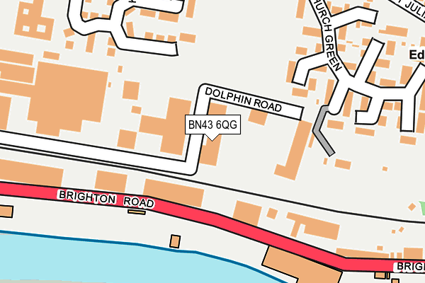
BN43 6QG is located in the St Mary's electoral ward, within the local authority district of Adur and the English Parliamentary constituency of East Worthing and Shoreham. The Sub Integrated Care Board (ICB) Location is NHS Sussex ICB - 70F and the police force is Sussex. This postcode has been in use since February 1990.


GetTheData
Source: OS OpenMap – Local (Ordnance Survey)
Source: OS VectorMap District (Ordnance Survey)
Licence: Open Government Licence (requires attribution)
| Easting | 523147 |
| Northing | 105138 |
| Latitude | 50.832685 |
| Longitude | -0.252656 |
GetTheData
Source: Open Postcode Geo
Licence: Open Government Licence
| Country | England |
| Postcode District | BN43 |
| ➜ BN43 open data dashboard ➜ See where BN43 is on a map ➜ Where is Shoreham-by-Sea? | |
GetTheData
Source: Land Registry Price Paid Data
Licence: Open Government Licence
Elevation or altitude of BN43 6QG as distance above sea level:
| Metres | Feet | |
|---|---|---|
| Elevation | 10m | 33ft |
Elevation is measured from the approximate centre of the postcode, to the nearest point on an OS contour line from OS Terrain 50, which has contour spacing of ten vertical metres.
➜ How high above sea level am I? Find the elevation of your current position using your device's GPS.
GetTheData
Source: Open Postcode Elevation
Licence: Open Government Licence
| Ward | St Mary's |
| Constituency | East Worthing And Shoreham |
GetTheData
Source: ONS Postcode Database
Licence: Open Government Licence
| June 2022 | Violence and sexual offences | On or near Sports/Recreation Area | 181m |
| June 2022 | Violence and sexual offences | On or near Sports/Recreation Area | 181m |
| June 2022 | Violence and sexual offences | On or near Kingsland Close | 242m |
| ➜ Get more crime data in our Crime section | |||
GetTheData
Source: data.police.uk
Licence: Open Government Licence
| Travis Perkins (Brighton Road A259) | Shoreham-by-sea | 100m |
| Travis Perkins (Brighton Road A259) | Shoreham-by-sea | 210m |
| Lighthouse (Brighton Road) | Shoreham-by-sea | 275m |
| Lighthouse (Brighton Road A259) | Shoreham-by-sea | 276m |
| Church Green (Middle Road) | Shoreham-by-sea | 292m |
| Southwick Station | 1.2km |
| Shoreham-by-Sea (Sussex) Station | 1.4km |
| Fishersgate Station | 2.3km |
GetTheData
Source: NaPTAN
Licence: Open Government Licence
GetTheData
Source: ONS Postcode Database
Licence: Open Government Licence


➜ Get more ratings from the Food Standards Agency
GetTheData
Source: Food Standards Agency
Licence: FSA terms & conditions
| Last Collection | |||
|---|---|---|---|
| Location | Mon-Fri | Sat | Distance |
| St Julians | 17:00 | 11:45 | 367m |
| The Burrells | 17:15 | 12:00 | 548m |
| Kingston Lane | 17:00 | 11:45 | 590m |
GetTheData
Source: Dracos
Licence: Creative Commons Attribution-ShareAlike
| Facility | Distance |
|---|---|
| Shoreham Academy Pitches Middle Road, Shoreham-by-sea Grass Pitches | 180m |
| Shoreham College St. Julians Lane, Shoreham-by-sea Swimming Pool, Grass Pitches, Sports Hall, Outdoor Tennis Courts | 420m |
| Shoreham Fc Middle Road, Shoreham-by-sea Grass Pitches | 460m |
GetTheData
Source: Active Places
Licence: Open Government Licence
| School | Phase of Education | Distance |
|---|---|---|
| Shoreham College St Julian's Lane, Shoreham by Sea, West Sussex, BN43 6YW | Not applicable | 420m |
| Shoreham Academy Kingston Lane, Shoreham-by-Sea, BN43 6YT | Secondary | 685m |
| Glebe Primary School Church Lane, Southwick, Brighton, BN42 4GB | Primary | 743m |
GetTheData
Source: Edubase
Licence: Open Government Licence
The below table lists the International Territorial Level (ITL) codes (formerly Nomenclature of Territorial Units for Statistics (NUTS) codes) and Local Administrative Units (LAU) codes for BN43 6QG:
| ITL 1 Code | Name |
|---|---|
| TLJ | South East (England) |
| ITL 2 Code | Name |
| TLJ2 | Surrey, East and West Sussex |
| ITL 3 Code | Name |
| TLJ27 | West Sussex (South West) |
| LAU 1 Code | Name |
| E07000223 | Adur |
GetTheData
Source: ONS Postcode Directory
Licence: Open Government Licence
The below table lists the Census Output Area (OA), Lower Layer Super Output Area (LSOA), and Middle Layer Super Output Area (MSOA) for BN43 6QG:
| Code | Name | |
|---|---|---|
| OA | E00159925 | |
| LSOA | E01031366 | Adur 004C |
| MSOA | E02006537 | Adur 004 |
GetTheData
Source: ONS Postcode Directory
Licence: Open Government Licence
| BN43 6AN | Dolphin Road | 124m |
| BN43 6JQ | Church Green | 174m |
| BN43 6RH | Brighton Road | 246m |
| BN43 6JW | Church Green | 261m |
| BN43 6JU | Church Green | 263m |
| BN43 6LG | Middle Road | 294m |
| BN43 6LF | St Julians Close | 360m |
| BN43 5PF | Sussex Wharf | 361m |
| BN43 6LL | Middle Road | 366m |
| BN43 5HZ | Harbour Way | 367m |
GetTheData
Source: Open Postcode Geo; Land Registry Price Paid Data
Licence: Open Government Licence