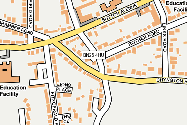
BN25 4HU lies on Southdown Road in Seaford. BN25 4HU is located in the Seaford South electoral ward, within the local authority district of Lewes and the English Parliamentary constituency of Lewes. The Sub Integrated Care Board (ICB) Location is NHS Sussex ICB - 97R and the police force is Sussex. This postcode has been in use since January 1980.


GetTheData
Source: OS OpenMap – Local (Ordnance Survey)
Source: OS VectorMap District (Ordnance Survey)
Licence: Open Government Licence (requires attribution)
| Easting | 549080 |
| Northing | 98811 |
| Latitude | 50.769730 |
| Longitude | 0.112815 |
GetTheData
Source: Open Postcode Geo
Licence: Open Government Licence
| Street | Southdown Road |
| Town/City | Seaford |
| Country | England |
| Postcode District | BN25 |
➜ See where BN25 is on a map ➜ Where is Seaford? | |
GetTheData
Source: Land Registry Price Paid Data
Licence: Open Government Licence
Elevation or altitude of BN25 4HU as distance above sea level:
| Metres | Feet | |
|---|---|---|
| Elevation | 10m | 33ft |
Elevation is measured from the approximate centre of the postcode, to the nearest point on an OS contour line from OS Terrain 50, which has contour spacing of ten vertical metres.
➜ How high above sea level am I? Find the elevation of your current position using your device's GPS.
GetTheData
Source: Open Postcode Elevation
Licence: Open Government Licence
| Ward | Seaford South |
| Constituency | Lewes |
GetTheData
Source: ONS Postcode Database
Licence: Open Government Licence
2012 2 AUG £598,300 |
LAMONT, SOUTHDOWN ROAD, SEAFORD, BN25 4HU 2007 29 JUN £350,000 |
2003 13 MAR £500,000 |
1998 2 DEC £210,000 |
GetTheData
Source: HM Land Registry Price Paid Data
Licence: Contains HM Land Registry data © Crown copyright and database right 2025. This data is licensed under the Open Government Licence v3.0.
| Links Road (Sutton Avenue) | Seaford | 220m |
| Seaford Head Lower School (Steyne Road) | Seaford | 274m |
| Arundel Road (Sutton Avenue) | Seaford | 345m |
| East Albany Road (Sutton Road) | Seaford | 577m |
| Downs Road (Sutton Road) | Seaford | 584m |
| Seaford Station | 1km |
| Bishopstone Station | 2.4km |
| Newhaven Harbour Station | 4.6km |
GetTheData
Source: NaPTAN
Licence: Open Government Licence
| Percentage of properties with Next Generation Access | 100.0% |
| Percentage of properties with Superfast Broadband | 100.0% |
| Percentage of properties with Ultrafast Broadband | 0.0% |
| Percentage of properties with Full Fibre Broadband | 0.0% |
Superfast Broadband is between 30Mbps and 300Mbps
Ultrafast Broadband is > 300Mbps
| Percentage of properties unable to receive 2Mbps | 0.0% |
| Percentage of properties unable to receive 5Mbps | 0.0% |
| Percentage of properties unable to receive 10Mbps | 0.0% |
| Percentage of properties unable to receive 30Mbps | 0.0% |
GetTheData
Source: Ofcom
Licence: Ofcom Terms of Use (requires attribution)
GetTheData
Source: ONS Postcode Database
Licence: Open Government Licence


➜ Get more ratings from the Food Standards Agency
GetTheData
Source: Food Standards Agency
Licence: FSA terms & conditions
| Last Collection | |||
|---|---|---|---|
| Location | Mon-Fri | Sat | Distance |
| Homefield Road | 17:05 | 12:00 | 1,145m |
| The Ridings | 17:05 | 12:00 | 1,600m |
| Hawth Hill | 16:30 | 07:15 | 2,459m |
GetTheData
Source: Dracos
Licence: Creative Commons Attribution-ShareAlike
The below table lists the International Territorial Level (ITL) codes (formerly Nomenclature of Territorial Units for Statistics (NUTS) codes) and Local Administrative Units (LAU) codes for BN25 4HU:
| ITL 1 Code | Name |
|---|---|
| TLJ | South East (England) |
| ITL 2 Code | Name |
| TLJ2 | Surrey, East and West Sussex |
| ITL 3 Code | Name |
| TLJ22 | East Sussex CC |
| LAU 1 Code | Name |
| E07000063 | Lewes |
GetTheData
Source: ONS Postcode Directory
Licence: Open Government Licence
The below table lists the Census Output Area (OA), Lower Layer Super Output Area (LSOA), and Middle Layer Super Output Area (MSOA) for BN25 4HU:
| Code | Name | |
|---|---|---|
| OA | E00107060 | |
| LSOA | E01021078 | Lewes 012E |
| MSOA | E02004390 | Lewes 012 |
GetTheData
Source: ONS Postcode Directory
Licence: Open Government Licence
| BN25 4HA | Chyngton Road | 64m |
| BN25 4LA | Sutton Avenue | 80m |
| BN25 4LE | Sutton Avenue | 92m |
| BN25 4HF | Chyngton Road | 99m |
| BN25 4HE | Chyngton Road | 102m |
| BN25 4HD | Chyngton Road | 108m |
| BN25 4HT | Rother Road | 111m |
| BN25 4HG | Southdown Corner | 117m |
| BN25 4HB | Chyngton Road | 118m |
| BN25 4PG | Southdown Road | 127m |
GetTheData
Source: Open Postcode Geo; Land Registry Price Paid Data
Licence: Open Government Licence