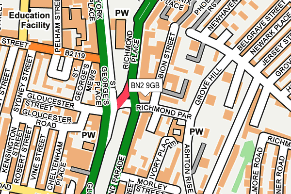
BN2 9GB is located in the Queen's Park electoral ward, within the unitary authority of Brighton and Hove and the English Parliamentary constituency of Brighton, Kemptown. The Sub Integrated Care Board (ICB) Location is NHS Sussex ICB - 09D and the police force is Sussex. This postcode has been in use since December 2001.


GetTheData
Source: OS OpenMap – Local (Ordnance Survey)
Source: OS VectorMap District (Ordnance Survey)
Licence: Open Government Licence (requires attribution)
| Easting | 531498 |
| Northing | 104728 |
| Latitude | 50.827165 |
| Longitude | -0.134282 |
GetTheData
Source: Open Postcode Geo
Licence: Open Government Licence
| Country | England |
| Postcode District | BN2 |
| ➜ BN2 open data dashboard ➜ See where BN2 is on a map ➜ Where is Brighton? | |
GetTheData
Source: Land Registry Price Paid Data
Licence: Open Government Licence
Elevation or altitude of BN2 9GB as distance above sea level:
| Metres | Feet | |
|---|---|---|
| Elevation | 20m | 66ft |
Elevation is measured from the approximate centre of the postcode, to the nearest point on an OS contour line from OS Terrain 50, which has contour spacing of ten vertical metres.
➜ How high above sea level am I? Find the elevation of your current position using your device's GPS.
GetTheData
Source: Open Postcode Elevation
Licence: Open Government Licence
| Ward | Queen's Park |
| Constituency | Brighton, Kemptown |
GetTheData
Source: ONS Postcode Database
Licence: Open Government Licence
| January 2024 | Public order | On or near Parking Area | 384m |
| January 2024 | Violence and sexual offences | On or near Parking Area | 384m |
| January 2024 | Anti-social behaviour | On or near Theatre/Concert Hall | 436m |
| ➜ Get more crime data in our Crime section | |||
GetTheData
Source: data.police.uk
Licence: Open Government Licence
| St Peters Church (Gloucester Place) | Brighton | 75m |
| St Peters Church (Richmond Place) | Brighton | 99m |
| St Peters Church (York Place) | Brighton | 103m |
| St Peters Church (York Place) | Brighton | 120m |
| St Peters Church (Richmond Place) | Brighton | 138m |
| Brighton Station | 0.5km |
| London Road (Brighton) Station | 1.1km |
| Moulsecoomb Station | 2.4km |
GetTheData
Source: NaPTAN
Licence: Open Government Licence
GetTheData
Source: ONS Postcode Database
Licence: Open Government Licence

➜ Get more ratings from the Food Standards Agency
GetTheData
Source: Food Standards Agency
Licence: FSA terms & conditions
| Last Collection | |||
|---|---|---|---|
| Location | Mon-Fri | Sat | Distance |
| Richmond Parade | 18:00 | 11:30 | 27m |
| Gloucester Place | 18:30 | 13:15 | 179m |
| Pelham Square | 18:30 | 13:15 | 206m |
GetTheData
Source: Dracos
Licence: Creative Commons Attribution-ShareAlike
| Facility | Distance |
|---|---|
| The Phoenix Community Centre Phoenix Place, Brighton Sports Hall | 208m |
| Prince Regent Swimming Complex North Road, Brighton Swimming Pool, Health and Fitness Gym | 368m |
| Puregym (Brighton London Road) London Road, Brighton Health and Fitness Gym | 476m |
GetTheData
Source: Active Places
Licence: Open Government Licence
| School | Phase of Education | Distance |
|---|---|---|
| Carlton Hill Primary School Sussex Street, BRIGHTON, BN2 9HS | Primary | 315m |
| Kings Brighton 27-33 Ditchling Road, Brighton, BN1 4SB | Not applicable | 366m |
| Tarnerland Nursery School Sussex Street, Brighton, BN2 0GR | Nursery | 371m |
GetTheData
Source: Edubase
Licence: Open Government Licence
The below table lists the International Territorial Level (ITL) codes (formerly Nomenclature of Territorial Units for Statistics (NUTS) codes) and Local Administrative Units (LAU) codes for BN2 9GB:
| ITL 1 Code | Name |
|---|---|
| TLJ | South East (England) |
| ITL 2 Code | Name |
| TLJ2 | Surrey, East and West Sussex |
| ITL 3 Code | Name |
| TLJ21 | Brighton and Hove |
| LAU 1 Code | Name |
| E06000043 | Brighton and Hove |
GetTheData
Source: ONS Postcode Directory
Licence: Open Government Licence
The below table lists the Census Output Area (OA), Lower Layer Super Output Area (LSOA), and Middle Layer Super Output Area (MSOA) for BN2 9GB:
| Code | Name | |
|---|---|---|
| OA | E00085560 | |
| LSOA | E01016947 | Brighton and Hove 030C |
| MSOA | E02003520 | Brighton and Hove 030 |
GetTheData
Source: ONS Postcode Directory
Licence: Open Government Licence
| BN2 9PS | Albion Street | 56m |
| BN2 9NF | Grove Bank | 80m |
| BN2 9QD | Richmond Parade | 83m |
| BN2 9NA | Richmond Place | 86m |
| BN2 9AB | Ivory Place | 88m |
| BN2 9NE | Albion Street | 99m |
| BN2 9QE | Ivory Place | 100m |
| BN1 4GA | St Georges Place | 101m |
| BN2 9PN | Albion Street | 101m |
| BN2 9QB | Grand Parade | 103m |
GetTheData
Source: Open Postcode Geo; Land Registry Price Paid Data
Licence: Open Government Licence