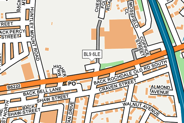
BL9 6LE is located in the Moorside electoral ward, within the metropolitan district of Bury and the English Parliamentary constituency of Bury North. The Sub Integrated Care Board (ICB) Location is NHS Greater Manchester ICB - 00V and the police force is Greater Manchester. This postcode has been in use since December 1999.


GetTheData
Source: OS OpenMap – Local (Ordnance Survey)
Source: OS VectorMap District (Ordnance Survey)
Licence: Open Government Licence (requires attribution)
| Easting | 381870 |
| Northing | 411338 |
| Latitude | 53.598294 |
| Longitude | -2.275419 |
GetTheData
Source: Open Postcode Geo
Licence: Open Government Licence
| Country | England |
| Postcode District | BL9 |
| ➜ BL9 open data dashboard ➜ See where BL9 is on a map ➜ Where is Bury? | |
GetTheData
Source: Land Registry Price Paid Data
Licence: Open Government Licence
Elevation or altitude of BL9 6LE as distance above sea level:
| Metres | Feet | |
|---|---|---|
| Elevation | 100m | 328ft |
Elevation is measured from the approximate centre of the postcode, to the nearest point on an OS contour line from OS Terrain 50, which has contour spacing of ten vertical metres.
➜ How high above sea level am I? Find the elevation of your current position using your device's GPS.
GetTheData
Source: Open Postcode Elevation
Licence: Open Government Licence
| Ward | Moorside |
| Constituency | Bury North |
GetTheData
Source: ONS Postcode Database
Licence: Open Government Licence
| September 2021 | Violence and sexual offences | On or near Almond Avenue | 251m |
| September 2021 | Violence and sexual offences | On or near Almond Avenue | 251m |
| August 2021 | Violence and sexual offences | On or near Dove Drive | 256m |
| ➜ Get more crime data in our Crime section | |||
GetTheData
Source: data.police.uk
Licence: Open Government Licence
| Rochdale Old Rd/Chesham Fold Rd (Rochdale Old Rd) | Bury | 44m |
| Bell Ln/Chesham Fold Rd (Bell Ln) | Bury | 65m |
| Huntley Mount Rd/Percy St (Huntley Mount R) | Freetown | 209m |
| Huntley Mount Rd/Percy St (Huntley Mount R) | Freetown | 217m |
| Bell Ln/Aldi (Bell Ln) | Bury | 218m |
| Bury (Manchester Metrolink) (The Haymarket) | Bury | 1,651m |
GetTheData
Source: NaPTAN
Licence: Open Government Licence
GetTheData
Source: ONS Postcode Database
Licence: Open Government Licence


➜ Get more ratings from the Food Standards Agency
GetTheData
Source: Food Standards Agency
Licence: FSA terms & conditions
| Last Collection | |||
|---|---|---|---|
| Location | Mon-Fri | Sat | Distance |
| Hornby Buildings | 18:30 | 11:00 | 1,294m |
| Houghton Street | 17:40 | 11:10 | 1,402m |
| 200 Railway Street | 17:40 | 11:00 | 1,610m |
GetTheData
Source: Dracos
Licence: Creative Commons Attribution-ShareAlike
| Facility | Distance |
|---|---|
| Hoyles Park Thrush Drive, Bury Grass Pitches | 310m |
| St Pauls C Of E Primary School Porritt Street, Bury Grass Pitches | 397m |
| Hazelwood High School Hazel Avenue, Bury Sports Hall, Health and Fitness Gym, Artificial Grass Pitch, Grass Pitches, Studio, Outdoor Tennis Courts | 530m |
GetTheData
Source: Active Places
Licence: Open Government Licence
| School | Phase of Education | Distance |
|---|---|---|
| Hoyle Nursery School Chesham Fold Road, Bury, BL9 6HR | Nursery | 197m |
| Cambian Chesham House School Chesham House, Thrush Drive, Bury, BL9 6JD | Not applicable | 320m |
| East Ward Community Primary School Willow Street, Bury, BL9 7QZ | Primary | 343m |
GetTheData
Source: Edubase
Licence: Open Government Licence
The below table lists the International Territorial Level (ITL) codes (formerly Nomenclature of Territorial Units for Statistics (NUTS) codes) and Local Administrative Units (LAU) codes for BL9 6LE:
| ITL 1 Code | Name |
|---|---|
| TLD | North West (England) |
| ITL 2 Code | Name |
| TLD3 | Greater Manchester |
| ITL 3 Code | Name |
| TLD37 | Greater Manchester North East |
| LAU 1 Code | Name |
| E08000002 | Bury |
GetTheData
Source: ONS Postcode Directory
Licence: Open Government Licence
The below table lists the Census Output Area (OA), Lower Layer Super Output Area (LSOA), and Middle Layer Super Output Area (MSOA) for BL9 6LE:
| Code | Name | |
|---|---|---|
| OA | E00025095 | |
| LSOA | E01004960 | Bury 007E |
| MSOA | E02001025 | Bury 007 |
GetTheData
Source: ONS Postcode Directory
Licence: Open Government Licence
| BL9 6HS | Bell Lane | 106m |
| BL9 6HT | Bell Lane | 122m |
| BL9 7LQ | Rochdale Old Road | 128m |
| BL9 7PT | Shaw Street | 167m |
| BL9 7PP | Craven Street | 167m |
| BL9 7QR | Walnut Avenue | 173m |
| BL9 7PS | Willow Street | 185m |
| BL9 7QP | Rowan Drive | 192m |
| BL9 7LP | Rochdale Old Road | 208m |
| BL9 6HY | Huntley Mount Road | 228m |
GetTheData
Source: Open Postcode Geo; Land Registry Price Paid Data
Licence: Open Government Licence