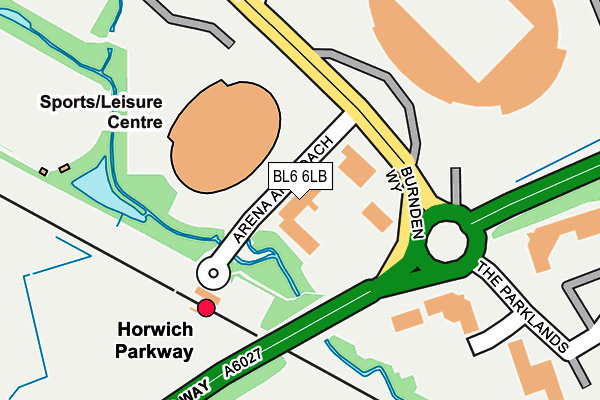
BL6 6LB is located in the Horwich South & Blackrod electoral ward, within the metropolitan district of Bolton and the English Parliamentary constituency of Bolton West. The Sub Integrated Care Board (ICB) Location is NHS Greater Manchester ICB - 00T and the police force is Greater Manchester. This postcode has been in use since December 1997.


GetTheData
Source: OS OpenMap – Local (Ordnance Survey)
Source: OS VectorMap District (Ordnance Survey)
Licence: Open Government Licence (requires attribution)
| Easting | 364471 |
| Northing | 409276 |
| Latitude | 53.578867 |
| Longitude | -2.538075 |
GetTheData
Source: Open Postcode Geo
Licence: Open Government Licence
| Country | England |
| Postcode District | BL6 |
➜ See where BL6 is on a map ➜ Where is Horwich? | |
GetTheData
Source: Land Registry Price Paid Data
Licence: Open Government Licence
Elevation or altitude of BL6 6LB as distance above sea level:
| Metres | Feet | |
|---|---|---|
| Elevation | 110m | 361ft |
Elevation is measured from the approximate centre of the postcode, to the nearest point on an OS contour line from OS Terrain 50, which has contour spacing of ten vertical metres.
➜ How high above sea level am I? Find the elevation of your current position using your device's GPS.
GetTheData
Source: Open Postcode Elevation
Licence: Open Government Licence
| Ward | Horwich South & Blackrod |
| Constituency | Bolton West |
GetTheData
Source: ONS Postcode Database
Licence: Open Government Licence
| Horwich Parkway Station (Horwicy Parkway) | Middlebrook | 105m |
| Burnden Way/Macron Stadium (Burnden Way) | Middlebrook | 229m |
| Burnden Way/Macron Stadium (Burnden Way) | Middlebrook | 257m |
| Parklands/Middlebrook Business Park (Parklands) | Middlebrook | 275m |
| Parklands/Middlebrook Business Park (Parklands) | Middlebrook | 284m |
| Horwich Parkway Station | 0.1km |
| Blackrod Station | 2.5km |
| Westhoughton Station | 2.8km |
GetTheData
Source: NaPTAN
Licence: Open Government Licence
GetTheData
Source: ONS Postcode Database
Licence: Open Government Licence


➜ Get more ratings from the Food Standards Agency
GetTheData
Source: Food Standards Agency
Licence: FSA terms & conditions
| Last Collection | |||
|---|---|---|---|
| Location | Mon-Fri | Sat | Distance |
| Lower Brazeley P O | 17:15 | 12:10 | 1,212m |
| Winter Hey Lane P O | 18:45 | 12:05 | 2,312m |
| 205 Crown Lane | 17:35 | 11:20 | 2,413m |
GetTheData
Source: Dracos
Licence: Creative Commons Attribution-ShareAlike
| Risk of BL6 6LB flooding from rivers and sea | Medium |
| ➜ BL6 6LB flood map | |
GetTheData
Source: Open Flood Risk by Postcode
Licence: Open Government Licence
The below table lists the International Territorial Level (ITL) codes (formerly Nomenclature of Territorial Units for Statistics (NUTS) codes) and Local Administrative Units (LAU) codes for BL6 6LB:
| ITL 1 Code | Name |
|---|---|
| TLD | North West (England) |
| ITL 2 Code | Name |
| TLD3 | Greater Manchester |
| ITL 3 Code | Name |
| TLD36 | Greater Manchester North West |
| LAU 1 Code | Name |
| E08000001 | Bolton |
GetTheData
Source: ONS Postcode Directory
Licence: Open Government Licence
The below table lists the Census Output Area (OA), Lower Layer Super Output Area (LSOA), and Middle Layer Super Output Area (MSOA) for BL6 6LB:
| Code | Name | |
|---|---|---|
| OA | E00024189 | |
| LSOA | E01004775 | Bolton 014A |
| MSOA | E02000997 | Bolton 014 |
GetTheData
Source: ONS Postcode Directory
Licence: Open Government Licence
| BL6 6JA | The Linkway | 551m |
| BL6 6RJ | Holbeck Close | 712m |
| BL6 6RL | Calderburn Close | 737m |
| BL6 6RN | Ashburn Close | 800m |
| BL6 4GG | Lostock Lane | 801m |
| BL6 6SR | Springburn Close | 812m |
| BL6 6RH | Holmebrook Drive | 834m |
| BL6 6HL | Springfield Road | 881m |
| BL6 4BP | Lostock Lane | 897m |
| BL6 6SG | Glenbeck Close | 899m |
GetTheData
Source: Open Postcode Geo; Land Registry Price Paid Data
Licence: Open Government Licence