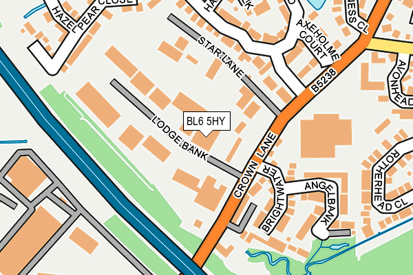
BL6 5HY lies on Crown Lane in Horwich, Bolton. BL6 5HY is located in the Horwich South & Blackrod electoral ward, within the metropolitan district of Bolton and the English Parliamentary constituency of Bolton West. The Sub Integrated Care Board (ICB) Location is NHS Greater Manchester ICB - 00T and the police force is Greater Manchester. This postcode has been in use since January 1980.


GetTheData
Source: OS OpenMap – Local (Ordnance Survey)
Source: OS VectorMap District (Ordnance Survey)
Licence: Open Government Licence (requires attribution)
| Easting | 362706 |
| Northing | 410987 |
| Latitude | 53.594137 |
| Longitude | -2.564935 |
GetTheData
Source: Open Postcode Geo
Licence: Open Government Licence
| Street | Crown Lane |
| Locality | Horwich |
| Town/City | Bolton |
| Country | England |
| Postcode District | BL6 |
| ➜ BL6 open data dashboard ➜ See where BL6 is on a map ➜ Where is Horwich? | |
GetTheData
Source: Land Registry Price Paid Data
Licence: Open Government Licence
Elevation or altitude of BL6 5HY as distance above sea level:
| Metres | Feet | |
|---|---|---|
| Elevation | 110m | 361ft |
Elevation is measured from the approximate centre of the postcode, to the nearest point on an OS contour line from OS Terrain 50, which has contour spacing of ten vertical metres.
➜ How high above sea level am I? Find the elevation of your current position using your device's GPS.
GetTheData
Source: Open Postcode Elevation
Licence: Open Government Licence
| Ward | Horwich South & Blackrod |
| Constituency | Bolton West |
GetTheData
Source: ONS Postcode Database
Licence: Open Government Licence
| October 2023 | Violence and sexual offences | On or near Owsten Court | 301m |
| September 2023 | Vehicle crime | On or near Owsten Court | 301m |
| May 2022 | Violence and sexual offences | On or near Hazel Pear Close | 309m |
| ➜ Crown Lane crime map and outcomes | |||
GetTheData
Source: data.police.uk
Licence: Open Government Licence
| Crown Ln/Butterwick Fields (Crown Ln) | Horwich | 103m |
| Crown Lane/Butterwick Fields (Crown Lane) | Horwich | 185m |
| Vale Avenue/Crown Lane (Vale Avenue) | Horwich | 319m |
| Vale Avenue/Avonhead Close (Vale Avenue) | Horwich | 334m |
| Station Road/Blackrod Station (Station Road) | Blackrod | 385m |
| Blackrod Station | 0.4km |
| Horwich Parkway Station | 2.4km |
| Adlington (Lancs) Station | 3.3km |
GetTheData
Source: NaPTAN
Licence: Open Government Licence
| Median download speed | 57.7Mbps |
| Average download speed | 47.9Mbps |
| Maximum download speed | 71.77Mbps |
| Median upload speed | 17.6Mbps |
| Average upload speed | 13.7Mbps |
| Maximum upload speed | 20.00Mbps |
GetTheData
Source: Ofcom
Licence: Ofcom Terms of Use (requires attribution)
GetTheData
Source: ONS Postcode Database
Licence: Open Government Licence


➜ Get more ratings from the Food Standards Agency
GetTheData
Source: Food Standards Agency
Licence: FSA terms & conditions
| Last Collection | |||
|---|---|---|---|
| Location | Mon-Fri | Sat | Distance |
| 205 Crown Lane | 17:35 | 11:20 | 557m |
| Blackrod P O | 18:30 | 11:30 | 1,004m |
| Rawlinson Bridge | 17:15 | 10:30 | 1,026m |
GetTheData
Source: Dracos
Licence: Creative Commons Attribution-ShareAlike
| Facility | Distance |
|---|---|
| St Catherines School Greenstone Avenue, Horwich, Bolton Sports Hall | 650m |
| Hilton Community Centre Playing Fields Nuttall Avenue, Horwich, Bolton Grass Pitches | 663m |
| Hilton Table Tennis Centre Nuttall Avenue, Horwich, Bolton Sports Hall | 696m |
GetTheData
Source: Active Places
Licence: Open Government Licence
| School | Phase of Education | Distance |
|---|---|---|
| St Catherine's CofE Primary School Greenstone Avenue, Horwich, Bolton, BL6 5SJ | Primary | 651m |
| Blackrod Primary School Manchester Road, Blackrod, Manchester Road,, Blackrod, BOLTON, BL6 5SY | Primary | 1.2km |
| Beacon Primary School Peter Martin Street, Horwich, Bolton, BL6 7AL | Primary | 1.4km |
GetTheData
Source: Edubase
Licence: Open Government Licence
The below table lists the International Territorial Level (ITL) codes (formerly Nomenclature of Territorial Units for Statistics (NUTS) codes) and Local Administrative Units (LAU) codes for BL6 5HY:
| ITL 1 Code | Name |
|---|---|
| TLD | North West (England) |
| ITL 2 Code | Name |
| TLD3 | Greater Manchester |
| ITL 3 Code | Name |
| TLD36 | Greater Manchester North West |
| LAU 1 Code | Name |
| E08000001 | Bolton |
GetTheData
Source: ONS Postcode Directory
Licence: Open Government Licence
The below table lists the Census Output Area (OA), Lower Layer Super Output Area (LSOA), and Middle Layer Super Output Area (MSOA) for BL6 5HY:
| Code | Name | |
|---|---|---|
| OA | E00171700 | |
| LSOA | E01004780 | Bolton 009B |
| MSOA | E02000992 | Bolton 009 |
GetTheData
Source: ONS Postcode Directory
Licence: Open Government Licence
| BL6 5HZ | Crown Lane | 115m |
| BL6 5GW | Brightwater | 133m |
| BL6 5GY | Butterwick Fields | 171m |
| BL6 5GX | Angelbank | 191m |
| BL6 5HQ | Axholme Court | 197m |
| BL6 5HT | Haxey Walk | 210m |
| BL6 5GS | Hazel Pear Close | 228m |
| BL6 5GZ | Butterwick Fields | 261m |
| BL6 5UG | Rotherhead Close | 270m |
| BL6 5GU | Bensey Rise | 275m |
GetTheData
Source: Open Postcode Geo; Land Registry Price Paid Data
Licence: Open Government Licence