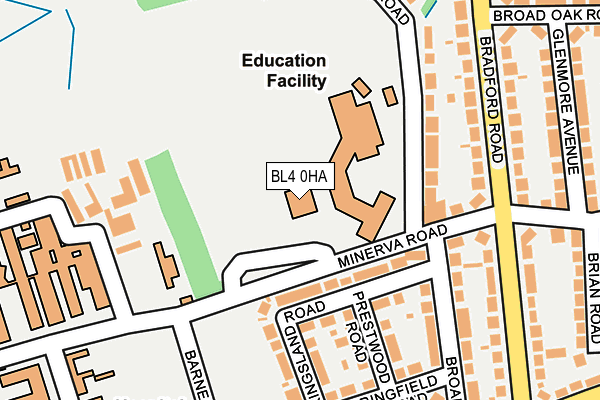
BL4 0HA is located in the Farnworth North electoral ward, within the metropolitan district of Bolton and the English Parliamentary constituency of Bolton South East. The Sub Integrated Care Board (ICB) Location is NHS Greater Manchester ICB - 00T and the police force is Greater Manchester. This postcode has been in use since April 2006.


GetTheData
Source: OS OpenMap – Local (Ordnance Survey)
Source: OS VectorMap District (Ordnance Survey)
Licence: Open Government Licence (requires attribution)
| Easting | 371993 |
| Northing | 406570 |
| Latitude | 53.555002 |
| Longitude | -2.424228 |
GetTheData
Source: Open Postcode Geo
Licence: Open Government Licence
| Country | England |
| Postcode District | BL4 |
| ➜ BL4 open data dashboard ➜ See where BL4 is on a map ➜ Where is Farnworth? | |
GetTheData
Source: Land Registry Price Paid Data
Licence: Open Government Licence
Elevation or altitude of BL4 0HA as distance above sea level:
| Metres | Feet | |
|---|---|---|
| Elevation | 110m | 361ft |
Elevation is measured from the approximate centre of the postcode, to the nearest point on an OS contour line from OS Terrain 50, which has contour spacing of ten vertical metres.
➜ How high above sea level am I? Find the elevation of your current position using your device's GPS.
GetTheData
Source: Open Postcode Elevation
Licence: Open Government Licence
| Ward | Farnworth North |
| Constituency | Bolton South East |
GetTheData
Source: ONS Postcode Database
Licence: Open Government Licence
| March 2022 | Violence and sexual offences | On or near Rishton Avenue | 448m |
| ➜ Get more crime data in our Crime section | |||
GetTheData
Source: data.police.uk
Licence: Open Government Licence
| Minerva Rd/Mount St Joseph Sch (Minerva Road) | Royal Bolton Hospital | 40m |
| Minerva Rd/Mount St Joseph Sch (Minerva Road) | Royal Bolton Hospital | 46m |
| Minerva Road/Mount St Joseph School (Minerva Road) | Royal Bolton Hospital | 60m |
| Minerva Rd/Mount St Joseph Sch (Minerva Rd) | Royal Bolton Hospital | 68m |
| Minerva Road/St Joseph's School (Minerva Road) | Royal Bolton Hospital | 69m |
| Moses Gate Station | 1.5km |
| Bolton Station | 2.1km |
| Farnworth Station | 2.5km |
GetTheData
Source: NaPTAN
Licence: Open Government Licence
GetTheData
Source: ONS Postcode Database
Licence: Open Government Licence


➜ Get more ratings from the Food Standards Agency
GetTheData
Source: Food Standards Agency
Licence: FSA terms & conditions
| Last Collection | |||
|---|---|---|---|
| Location | Mon-Fri | Sat | Distance |
| Great Lever P O | 18:30 | 11:40 | 642m |
| Bolton Mail Centre | 19:30 | 13:00 | 814m |
| 87 Cawdor Street | 17:40 | 12:50 | 1,050m |
GetTheData
Source: Dracos
Licence: Creative Commons Attribution-ShareAlike
| Facility | Distance |
|---|---|
| Mount St Joseph School Greenland Road, Bolton Health and Fitness Gym, Grass Pitches, Sports Hall | 51m |
| Farnworth Cricket And Bowling Club Lavender Road, Farnworth, Bolton Grass Pitches | 469m |
| Bolton Cricket Club Bishops Road, Bolton Grass Pitches, Outdoor Tennis Courts | 580m |
GetTheData
Source: Active Places
Licence: Open Government Licence
| School | Phase of Education | Distance |
|---|---|---|
| Mount St Joseph Greenland Road, Bolton, BL4 0HT | Secondary | 133m |
| Lord's School Brooklyn, Green Lane, Bolton, Bolton, BL3 2EF | Not applicable | 505m |
| Ss Simon & Jude CofE Primary School, Bolton Newport Road, Great Lever, Bolton, BL3 2DT | Primary | 760m |
GetTheData
Source: Edubase
Licence: Open Government Licence
The below table lists the International Territorial Level (ITL) codes (formerly Nomenclature of Territorial Units for Statistics (NUTS) codes) and Local Administrative Units (LAU) codes for BL4 0HA:
| ITL 1 Code | Name |
|---|---|
| TLD | North West (England) |
| ITL 2 Code | Name |
| TLD3 | Greater Manchester |
| ITL 3 Code | Name |
| TLD36 | Greater Manchester North West |
| LAU 1 Code | Name |
| E08000001 | Bolton |
GetTheData
Source: ONS Postcode Directory
Licence: Open Government Licence
The below table lists the Census Output Area (OA), Lower Layer Super Output Area (LSOA), and Middle Layer Super Output Area (MSOA) for BL4 0HA:
| Code | Name | |
|---|---|---|
| OA | E00024681 | |
| LSOA | E01004880 | Bolton 029E |
| MSOA | E02001012 | Bolton 029 |
GetTheData
Source: ONS Postcode Directory
Licence: Open Government Licence
| BL4 0HU | Greenland Road | 133m |
| BL4 0HW | Kingsland Road | 144m |
| BL4 0HX | Minerva Road | 151m |
| BL4 0HP | Prestwood Road | 157m |
| BL3 2EP | Greenland Road | 174m |
| BL4 0HZ | Bradford Road | 179m |
| BL4 0HL | Broadway | 208m |
| BL4 0JA | Bradford Road | 221m |
| BL4 0HN | Springfield Road | 229m |
| BL4 0HY | Bradford Road | 229m |
GetTheData
Source: Open Postcode Geo; Land Registry Price Paid Data
Licence: Open Government Licence