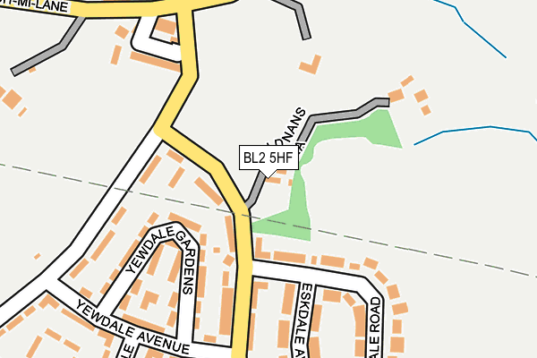
BL2 5HF is located in the Breightmet electoral ward, within the metropolitan district of Bolton and the English Parliamentary constituency of Bolton North East. The Sub Integrated Care Board (ICB) Location is NHS Greater Manchester ICB - 00T and the police force is Greater Manchester. This postcode has been in use since December 1997.


GetTheData
Source: OS OpenMap – Local (Ordnance Survey)
Source: OS VectorMap District (Ordnance Survey)
Licence: Open Government Licence (requires attribution)
| Easting | 374845 |
| Northing | 410721 |
| Latitude | 53.592457 |
| Longitude | -2.381515 |
GetTheData
Source: Open Postcode Geo
Licence: Open Government Licence
| Country | England |
| Postcode District | BL2 |
| ➜ BL2 open data dashboard ➜ See where BL2 is on a map ➜ Where is Bolton? | |
GetTheData
Source: Land Registry Price Paid Data
Licence: Open Government Licence
Elevation or altitude of BL2 5HF as distance above sea level:
| Metres | Feet | |
|---|---|---|
| Elevation | 150m | 492ft |
Elevation is measured from the approximate centre of the postcode, to the nearest point on an OS contour line from OS Terrain 50, which has contour spacing of ten vertical metres.
➜ How high above sea level am I? Find the elevation of your current position using your device's GPS.
GetTheData
Source: Open Postcode Elevation
Licence: Open Government Licence
| Ward | Breightmet |
| Constituency | Bolton North East |
GetTheData
Source: ONS Postcode Database
Licence: Open Government Licence
| Newby Road/Playing Fields (Newby Road) | Withins | 144m |
| Newby Road/Playing Fields (Newby Road) | Withins | 153m |
| Stitch Mi Lane/Newby Road (Stitch Mi Lane) | Top O Th Brow | 220m |
| Stitch Mi Lane/Newby Road (Stitch Mi Lane) | Top O Th Brow | 225m |
| Stitch Mi Lane/Christ Church (Stitch Mi Lane) | Top O Th Brow | 266m |
| Hall i' th' Wood Station | 2.2km |
| Bromley Cross Station | 3.1km |
| Bolton Station | 3.6km |
GetTheData
Source: NaPTAN
Licence: Open Government Licence
| Percentage of properties with Next Generation Access | 100.0% |
| Percentage of properties with Superfast Broadband | 100.0% |
| Percentage of properties with Ultrafast Broadband | 0.0% |
| Percentage of properties with Full Fibre Broadband | 0.0% |
Superfast Broadband is between 30Mbps and 300Mbps
Ultrafast Broadband is > 300Mbps
| Percentage of properties unable to receive 2Mbps | 0.0% |
| Percentage of properties unable to receive 5Mbps | 0.0% |
| Percentage of properties unable to receive 10Mbps | 0.0% |
| Percentage of properties unable to receive 30Mbps | 0.0% |
GetTheData
Source: Ofcom
Licence: Ofcom Terms of Use (requires attribution)
GetTheData
Source: ONS Postcode Database
Licence: Open Government Licence


➜ Get more ratings from the Food Standards Agency
GetTheData
Source: Food Standards Agency
Licence: FSA terms & conditions
| Last Collection | |||
|---|---|---|---|
| Location | Mon-Fri | Sat | Distance |
| Breightmet P O | 18:30 | 12:05 | 1,442m |
| 55 Archer Avenue | 17:35 | 11:50 | 1,621m |
| Ainsworth Lane P O | 17:20 | 12:00 | 1,908m |
GetTheData
Source: Dracos
Licence: Creative Commons Attribution-ShareAlike
| Facility | Distance |
|---|---|
| Dolan Park Newby Road, Bolton Grass Pitches | 185m |
| Bolton St Catherines Academy (Closed) Newby Road, Bolton Grass Pitches, Sports Hall | 212m |
| Harwood Meadows Primary School Orchard Gardens, Bolton Grass Pitches | 436m |
GetTheData
Source: Active Places
Licence: Open Government Licence
| School | Phase of Education | Distance |
|---|---|---|
| Firwood High School Stitch MI Lane, Bolton, BL2 4HU | Not applicable | 318m |
| Harwood Meadows Primary School Orchard Gardens, Harwood, Bolton, BL2 3PS | Primary | 436m |
| Bolton St Catherine's Academy Stitch MI Lane, Bolton, BL2 4HU | All-through | 493m |
GetTheData
Source: Edubase
Licence: Open Government Licence
The below table lists the International Territorial Level (ITL) codes (formerly Nomenclature of Territorial Units for Statistics (NUTS) codes) and Local Administrative Units (LAU) codes for BL2 5HF:
| ITL 1 Code | Name |
|---|---|
| TLD | North West (England) |
| ITL 2 Code | Name |
| TLD3 | Greater Manchester |
| ITL 3 Code | Name |
| TLD36 | Greater Manchester North West |
| LAU 1 Code | Name |
| E08000001 | Bolton |
GetTheData
Source: ONS Postcode Directory
Licence: Open Government Licence
The below table lists the Census Output Area (OA), Lower Layer Super Output Area (LSOA), and Middle Layer Super Output Area (MSOA) for BL2 5HF:
| Code | Name | |
|---|---|---|
| OA | E00024253 | |
| LSOA | E01004785 | Bolton 006B |
| MSOA | E02000989 | Bolton 006 |
GetTheData
Source: ONS Postcode Directory
Licence: Open Government Licence
| BL2 5HZ | Deepdale Road | 77m |
| BL2 5JF | Yewdale Gardens | 146m |
| BL2 5JA | Newby Road | 176m |
| BL2 4HD | Limetree Drive | 194m |
| BL2 5HT | Dovedale Road | 195m |
| BL2 5HU | Eskdale Avenue | 210m |
| BL2 5JE | Yewdale Avenue | 213m |
| BL2 5HY | Deepdale Road | 245m |
| BL2 4HW | Sedgemoor Vale | 248m |
| BL2 5JW | Rothay Close | 249m |
GetTheData
Source: Open Postcode Geo; Land Registry Price Paid Data
Licence: Open Government Licence