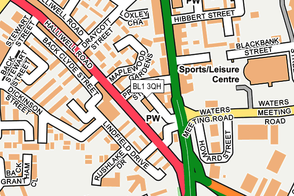
BL1 3QH is located in the Halliwell electoral ward, within the metropolitan district of Bolton and the English Parliamentary constituency of Bolton North East. The Sub Integrated Care Board (ICB) Location is NHS Greater Manchester ICB - 00T and the police force is Greater Manchester. This postcode has been in use since April 1986.


GetTheData
Source: OS OpenMap – Local (Ordnance Survey)
Source: OS VectorMap District (Ordnance Survey)
Licence: Open Government Licence (requires attribution)
| Easting | 371536 |
| Northing | 410447 |
| Latitude | 53.589824 |
| Longitude | -2.431481 |
GetTheData
Source: Open Postcode Geo
Licence: Open Government Licence
| Country | England |
| Postcode District | BL1 |
| ➜ BL1 open data dashboard ➜ See where BL1 is on a map ➜ Where is Bolton? | |
GetTheData
Source: Land Registry Price Paid Data
Licence: Open Government Licence
Elevation or altitude of BL1 3QH as distance above sea level:
| Metres | Feet | |
|---|---|---|
| Elevation | 110m | 361ft |
Elevation is measured from the approximate centre of the postcode, to the nearest point on an OS contour line from OS Terrain 50, which has contour spacing of ten vertical metres.
➜ How high above sea level am I? Find the elevation of your current position using your device's GPS.
GetTheData
Source: Open Postcode Elevation
Licence: Open Government Licence
| Ward | Halliwell |
| Constituency | Bolton North East |
GetTheData
Source: ONS Postcode Database
Licence: Open Government Licence
| September 2022 | Public order | On or near Mulliner Street | 39m |
| August 2021 | Violence and sexual offences | On or near Rainham Drive | 248m |
| ➜ Get more crime data in our Crime section | |||
GetTheData
Source: data.police.uk
Licence: Open Government Licence
| Blackburn Rd/Prospect St (Blackburn Road) | Halliwell | 56m |
| Halliwell Road/Adisham Drive (Halliwell Road) | Halliwell | 65m |
| Blackburn Rd/Waters Meeting Road (Blackburn Road) | Halliwell | 68m |
| Halliwell Road/Adisham Drive (Halliwell Road) | Halliwell | 85m |
| Blackburn Rd/Draycott St (Blackburn Road) | Halliwell | 182m |
| Hall i' th' Wood Station | 1.5km |
| Bolton Station | 1.8km |
| Bromley Cross Station | 3km |
GetTheData
Source: NaPTAN
Licence: Open Government Licence
GetTheData
Source: ONS Postcode Database
Licence: Open Government Licence


➜ Get more ratings from the Food Standards Agency
GetTheData
Source: Food Standards Agency
Licence: FSA terms & conditions
| Last Collection | |||
|---|---|---|---|
| Location | Mon-Fri | Sat | Distance |
| Bolton North Delivery Office | 18:45 | 553m | |
| Tennyson Street | 17:10 | 11:10 | 581m |
| Bolton North Delivery Office | 18:45 | 12:25 | 626m |
GetTheData
Source: Dracos
Licence: Creative Commons Attribution-ShareAlike
| Facility | Distance |
|---|---|
| Total Fitness (Bolton) Waters Meeting Road, Bolton Swimming Pool, Health and Fitness Gym, Studio, Squash Courts | 253m |
| St Matthews Primary School Kentford Road, Bolton Grass Pitches | 295m |
| Eden Boys School (Bolton) Wolfenden Street, Bolton Sports Hall, Artificial Grass Pitch, Health and Fitness Gym | 437m |
GetTheData
Source: Active Places
Licence: Open Government Licence
| School | Phase of Education | Distance |
|---|---|---|
| The Valley Community Primary School Hibbert Street, Off Blackburn Road, Bolton, BL1 8JG | Primary | 217m |
| St Matthew's CofE Primary School, Bolton Kentford Road, Halliwell, Bolton, BL1 2JL | Primary | 295m |
| The Olive School, Bolton Ashton House, Waterloo Street, Bolton, BL1 8HT | Primary | 333m |
GetTheData
Source: Edubase
Licence: Open Government Licence
The below table lists the International Territorial Level (ITL) codes (formerly Nomenclature of Territorial Units for Statistics (NUTS) codes) and Local Administrative Units (LAU) codes for BL1 3QH:
| ITL 1 Code | Name |
|---|---|
| TLD | North West (England) |
| ITL 2 Code | Name |
| TLD3 | Greater Manchester |
| ITL 3 Code | Name |
| TLD36 | Greater Manchester North West |
| LAU 1 Code | Name |
| E08000001 | Bolton |
GetTheData
Source: ONS Postcode Directory
Licence: Open Government Licence
The below table lists the Census Output Area (OA), Lower Layer Super Output Area (LSOA), and Middle Layer Super Output Area (MSOA) for BL1 3QH:
| Code | Name | |
|---|---|---|
| OA | E00024429 | |
| LSOA | E01004822 | Bolton 016B |
| MSOA | E02000999 | Bolton 016 |
GetTheData
Source: ONS Postcode Directory
Licence: Open Government Licence
| BL1 8HF | Blackburn Road | 43m |
| BL1 3NS | Maplewood House | 64m |
| BL1 3QS | Halliwell Road | 77m |
| BL1 3SA | Fernhurst Grove | 82m |
| BL1 3SE | Westwell Gardens | 85m |
| BL1 8DW | Blackburn Road | 90m |
| BL1 3NE | Halliwell Road | 94m |
| BL1 3SF | Kingsnorth Close | 105m |
| BL1 3NR | Maplewood Gardens | 106m |
| BL1 3SD | Adisham Drive | 121m |
GetTheData
Source: Open Postcode Geo; Land Registry Price Paid Data
Licence: Open Government Licence