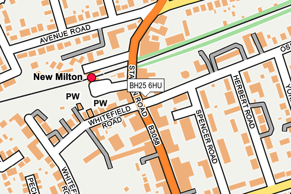
BH25 6HU lies on Station Road in New Milton. BH25 6HU is located in the Milton electoral ward, within the local authority district of New Forest and the English Parliamentary constituency of New Forest West. The Sub Integrated Care Board (ICB) Location is NHS Hampshire and Isle of Wight ICB - D9Y0V and the police force is Hampshire. This postcode has been in use since January 1980.


GetTheData
Source: OS OpenMap – Local (Ordnance Survey)
Source: OS VectorMap District (Ordnance Survey)
Licence: Open Government Licence (requires attribution)
| Easting | 424349 |
| Northing | 95141 |
| Latitude | 50.755360 |
| Longitude | -1.656185 |
GetTheData
Source: Open Postcode Geo
Licence: Open Government Licence
| Street | Station Road |
| Town/City | New Milton |
| Country | England |
| Postcode District | BH25 |
| ➜ BH25 open data dashboard ➜ See where BH25 is on a map ➜ Where is New Milton? | |
GetTheData
Source: Land Registry Price Paid Data
Licence: Open Government Licence
Elevation or altitude of BH25 6HU as distance above sea level:
| Metres | Feet | |
|---|---|---|
| Elevation | 40m | 131ft |
Elevation is measured from the approximate centre of the postcode, to the nearest point on an OS contour line from OS Terrain 50, which has contour spacing of ten vertical metres.
➜ How high above sea level am I? Find the elevation of your current position using your device's GPS.
GetTheData
Source: Open Postcode Elevation
Licence: Open Government Licence
| Ward | Milton |
| Constituency | New Forest West |
GetTheData
Source: ONS Postcode Database
Licence: Open Government Licence
| January 2024 | Bicycle theft | On or near Parking Area | 147m |
| January 2024 | Violence and sexual offences | On or near Fernglade | 302m |
| January 2024 | Anti-social behaviour | On or near Parking Area | 465m |
| ➜ Station Road crime map and outcomes | |||
GetTheData
Source: data.police.uk
Licence: Open Government Licence
| Whitefield Road Terminus (Whitefield Road) | New Milton | 50m |
| Station - New Forest Tour Only (Station Approach) | New Milton | 94m |
| Whitefield Road Terminus (Whitefield Road) | New Milton | 106m |
| Leigh Road (Avenue Road) | New Milton | 169m |
| Leigh Road (Avenue Road) | New Milton | 177m |
| New Milton Station | 0.1km |
| Hinton Admiral Station | 4.1km |
| Sway Station | 4.6km |
GetTheData
Source: NaPTAN
Licence: Open Government Licence
GetTheData
Source: ONS Postcode Database
Licence: Open Government Licence


➜ Get more ratings from the Food Standards Agency
GetTheData
Source: Food Standards Agency
Licence: FSA terms & conditions
| Last Collection | |||
|---|---|---|---|
| Location | Mon-Fri | Sat | Distance |
| Station Road (Leos) | 17:30 | 12:00 | 38m |
| Station Road West | 17:30 | 12:15 | 163m |
| Broadway | 17:30 | 11:30 | 186m |
GetTheData
Source: Dracos
Licence: Creative Commons Attribution-ShareAlike
| Facility | Distance |
|---|---|
| New Milton Indoor Bowls Club Whitefield Road, New Milton Indoor Bowls | 162m |
| New Milton Health And Leisure Gore Road, New Milton Sports Hall, Swimming Pool, Health and Fitness Gym, Studio, Squash Courts | 646m |
| Arnewood School Gore Road, New Milton Sports Hall, Grass Pitches, Health and Fitness Gym, Artificial Grass Pitch | 758m |
GetTheData
Source: Active Places
Licence: Open Government Licence
| School | Phase of Education | Distance |
|---|---|---|
| The Arnewood School Gore Road, New Milton, BH25 6RS | Secondary | 753m |
| Ballard School Fernhill Lane, New Milton, BH25 5SU | Not applicable | 758m |
| New Milton Junior School Old Milton Road, New Milton, BH25 6DS | Primary | 851m |
GetTheData
Source: Edubase
Licence: Open Government Licence
The below table lists the International Territorial Level (ITL) codes (formerly Nomenclature of Territorial Units for Statistics (NUTS) codes) and Local Administrative Units (LAU) codes for BH25 6HU:
| ITL 1 Code | Name |
|---|---|
| TLJ | South East (England) |
| ITL 2 Code | Name |
| TLJ3 | Hampshire and Isle of Wight |
| ITL 3 Code | Name |
| TLJ36 | Central Hampshire |
| LAU 1 Code | Name |
| E07000091 | New Forest |
GetTheData
Source: ONS Postcode Directory
Licence: Open Government Licence
The below table lists the Census Output Area (OA), Lower Layer Super Output Area (LSOA), and Middle Layer Super Output Area (MSOA) for BH25 6HU:
| Code | Name | |
|---|---|---|
| OA | E00117155 | |
| LSOA | E01023057 | New Forest 021E |
| MSOA | E02004799 | New Forest 021 |
GetTheData
Source: ONS Postcode Directory
Licence: Open Government Licence
| BH25 6HL | Station Road | 33m |
| BH25 6HR | Station Road | 34m |
| BH25 6JU | Station Road | 45m |
| BH25 6HX | Station Road | 80m |
| BH25 6JX | Station Road | 95m |
| BH25 6DE | Whitefield Road | 96m |
| BH25 6EP | Spencer Road | 120m |
| BH25 6JS | Railway Cottages | 128m |
| BH25 6FE | Osborne Road | 128m |
| BH25 6HN | Station Road | 141m |
GetTheData
Source: Open Postcode Geo; Land Registry Price Paid Data
Licence: Open Government Licence