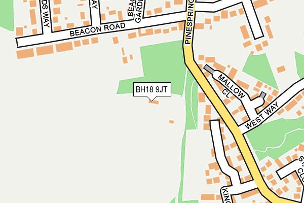
BH18 9JT lies on Roman Road in Broadstone. BH18 9JT is located in the Corfe Mullen electoral ward, within the unitary authority of Dorset and the English Parliamentary constituency of Mid Dorset and North Poole. The Sub Integrated Care Board (ICB) Location is NHS Dorset ICB - 11J and the police force is Dorset. This postcode has been in use since January 1980.


GetTheData
Source: OS OpenMap – Local (Ordnance Survey)
Source: OS VectorMap District (Ordnance Survey)
Licence: Open Government Licence (requires attribution)
| Easting | 399183 |
| Northing | 94995 |
| Latitude | 50.754542 |
| Longitude | -2.012942 |
GetTheData
Source: Open Postcode Geo
Licence: Open Government Licence
| Street | Roman Road |
| Town/City | Broadstone |
| Country | England |
| Postcode District | BH18 |
| ➜ BH18 open data dashboard ➜ See where BH18 is on a map | |
GetTheData
Source: Land Registry Price Paid Data
Licence: Open Government Licence
Elevation or altitude of BH18 9JT as distance above sea level:
| Metres | Feet | |
|---|---|---|
| Elevation | 30m | 98ft |
Elevation is measured from the approximate centre of the postcode, to the nearest point on an OS contour line from OS Terrain 50, which has contour spacing of ten vertical metres.
➜ How high above sea level am I? Find the elevation of your current position using your device's GPS.
GetTheData
Source: Open Postcode Elevation
Licence: Open Government Licence
| Ward | Corfe Mullen |
| Constituency | Mid Dorset And North Poole |
GetTheData
Source: ONS Postcode Database
Licence: Open Government Licence
| April 2023 | Criminal damage and arson | On or near Kingcup Close | 214m |
| March 2023 | Violence and sexual offences | On or near Stonecrop Close | 294m |
| February 2023 | Other theft | On or near Kingcup Close | 214m |
| ➜ Roman Road crime map and outcomes | |||
GetTheData
Source: data.police.uk
Licence: Open Government Licence
| Pinesprings Drive | Broadstone | 99m |
| Pinesprings Drive | Broadstone | 110m |
| Mallow Close (West Way) | Broadstone | 208m |
| Mallow Close (West Way) | Broadstone | 227m |
| Upton Way (Roman Road) | Broadstone | 307m |
| Hamworthy Station | 3.3km |
| Poole Station | 4.4km |
| Parkstone (Dorset) Station | 5.8km |
GetTheData
Source: NaPTAN
Licence: Open Government Licence
| Percentage of properties with Next Generation Access | 100.0% |
| Percentage of properties with Superfast Broadband | 100.0% |
| Percentage of properties with Ultrafast Broadband | 0.0% |
| Percentage of properties with Full Fibre Broadband | 0.0% |
Superfast Broadband is between 30Mbps and 300Mbps
Ultrafast Broadband is > 300Mbps
| Percentage of properties unable to receive 2Mbps | 0.0% |
| Percentage of properties unable to receive 5Mbps | 0.0% |
| Percentage of properties unable to receive 10Mbps | 0.0% |
| Percentage of properties unable to receive 30Mbps | 0.0% |
GetTheData
Source: Ofcom
Licence: Ofcom Terms of Use (requires attribution)
GetTheData
Source: ONS Postcode Database
Licence: Open Government Licence

➜ Get more ratings from the Food Standards Agency
GetTheData
Source: Food Standards Agency
Licence: FSA terms & conditions
| Last Collection | |||
|---|---|---|---|
| Location | Mon-Fri | Sat | Distance |
| Corfe Way | 17:15 | 11:45 | 339m |
| Claredon Road | 17:30 | 11:45 | 415m |
| Corfe Lodge Road | 17:15 | 11:45 | 487m |
GetTheData
Source: Dracos
Licence: Creative Commons Attribution-ShareAlike
| Facility | Distance |
|---|---|
| Hillbourne Primary School Kitchener Crescent, Kitchener Crescent, Poole Grass Pitches | 1.4km |
| The Junction Sports And Leisure Centre Station Approach, Broadstone Sports Hall, Swimming Pool, Health and Fitness Gym, Studio, Outdoor Tennis Courts | 1.6km |
| Corfe Hills School Higher Blandford Road, Broadstone Grass Pitches, Sports Hall | 1.7km |
GetTheData
Source: Active Places
Licence: Open Government Licence
| School | Phase of Education | Distance |
|---|---|---|
| Springdale First School Springdale Road, Broadstone, BH18 9BW | Primary | 770m |
| Hillbourne Primary School Kitchener Crescent, Poole, BH17 7HX | Primary | 1.5km |
| Rushcombe First School Hanham Road, Corfe Mullen, Wimborne, BH21 3PX | Primary | 1.5km |
GetTheData
Source: Edubase
Licence: Open Government Licence
The below table lists the International Territorial Level (ITL) codes (formerly Nomenclature of Territorial Units for Statistics (NUTS) codes) and Local Administrative Units (LAU) codes for BH18 9JT:
| ITL 1 Code | Name |
|---|---|
| TLK | South West (England) |
| ITL 2 Code | Name |
| TLK2 | Dorset and Somerset |
| ITL 3 Code | Name |
| TLK25 | Dorset |
| LAU 1 Code | Name |
| E06000059 | Dorset |
GetTheData
Source: ONS Postcode Directory
Licence: Open Government Licence
The below table lists the Census Output Area (OA), Lower Layer Super Output Area (LSOA), and Middle Layer Super Output Area (MSOA) for BH18 9JT:
| Code | Name | |
|---|---|---|
| OA | E00103300 | |
| LSOA | E01020388 | East Dorset 012G |
| MSOA | E02004254 | East Dorset 012 |
GetTheData
Source: ONS Postcode Directory
Licence: Open Government Licence
| BH18 9JL | Beacon Road | 168m |
| BH18 9NT | Mallow Close | 177m |
| BH18 9JN | Beacon Road | 180m |
| BH18 9JP | Beacon Road | 195m |
| BH18 9GS | Kingcup Close | 219m |
| BH18 9JY | Beacon Gardens | 248m |
| BH18 9JS | Roman Road | 260m |
| BH18 9JJ | Beacon Way | 264m |
| BH18 9JG | Maxwell Road | 293m |
| BH18 9LG | West Way | 294m |
GetTheData
Source: Open Postcode Geo; Land Registry Price Paid Data
Licence: Open Government Licence