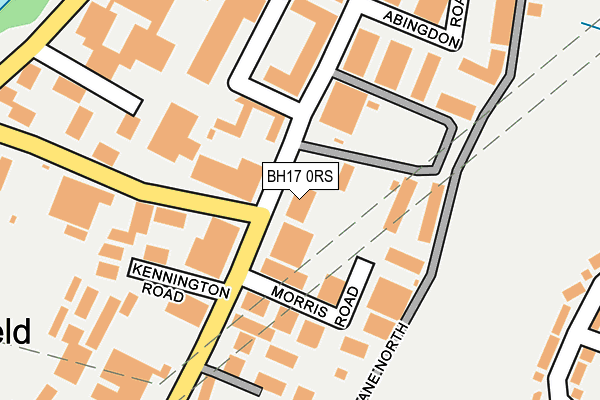
BH17 0RS lies on Nuffield Road in Nuffield Industrial Estate, Poole. BH17 0RS is located in the Canford Heath electoral ward, within the unitary authority of Bournemouth, Christchurch and Poole and the English Parliamentary constituency of Mid Dorset and North Poole. The Sub Integrated Care Board (ICB) Location is NHS Dorset ICB - 11J and the police force is Dorset. This postcode has been in use since July 1995.


GetTheData
Source: OS OpenMap – Local (Ordnance Survey)
Source: OS VectorMap District (Ordnance Survey)
Licence: Open Government Licence (requires attribution)
| Easting | 401821 |
| Northing | 93711 |
| Latitude | 50.743004 |
| Longitude | -1.975557 |
GetTheData
Source: Open Postcode Geo
Licence: Open Government Licence
| Street | Nuffield Road |
| Locality | Nuffield Industrial Estate |
| Town/City | Poole |
| Country | England |
| Postcode District | BH17 |
| ➜ BH17 open data dashboard ➜ See where BH17 is on a map ➜ Where is Poole? | |
GetTheData
Source: Land Registry Price Paid Data
Licence: Open Government Licence
Elevation or altitude of BH17 0RS as distance above sea level:
| Metres | Feet | |
|---|---|---|
| Elevation | 10m | 33ft |
Elevation is measured from the approximate centre of the postcode, to the nearest point on an OS contour line from OS Terrain 50, which has contour spacing of ten vertical metres.
➜ How high above sea level am I? Find the elevation of your current position using your device's GPS.
GetTheData
Source: Open Postcode Elevation
Licence: Open Government Licence
| Ward | Canford Heath |
| Constituency | Mid Dorset And North Poole |
GetTheData
Source: ONS Postcode Database
Licence: Open Government Licence
62 - 64, NUFFIELD ROAD, NUFFIELD INDUSTRIAL ESTATE, POOLE, BH17 0RS 2019 4 JAN £380,000 |
62 - 64, NUFFIELD ROAD, NUFFIELD INDUSTRIAL ESTATE, POOLE, BH17 0RS 2002 18 JAN £225,000 |
GetTheData
Source: HM Land Registry Price Paid Data
Licence: Contains HM Land Registry data © Crown copyright and database right 2024. This data is licensed under the Open Government Licence v3.0.
| August 2023 | Anti-social behaviour | On or near Stinsford Road | 392m |
| June 2022 | Public order | On or near Kennington Road | 149m |
| June 2022 | Violence and sexual offences | On or near Kennington Road | 149m |
| ➜ Nuffield Road crime map and outcomes | |||
GetTheData
Source: data.police.uk
Licence: Open Government Licence
| Cowley Road | Canford Heath | 183m |
| Hatch Pond Road | Canford Heath | 231m |
| Witney Road (Stinsford Road) | Canford Heath | 346m |
| Gibson Road (Adastral Road) | Canford Heath | 453m |
| Bader Road (Adastral Road) | Canford Heath | 488m |
| Poole Station | 2.7km |
| Parkstone (Dorset) Station | 3km |
| Hamworthy Station | 3.7km |
GetTheData
Source: NaPTAN
Licence: Open Government Licence
GetTheData
Source: ONS Postcode Database
Licence: Open Government Licence


➜ Get more ratings from the Food Standards Agency
GetTheData
Source: Food Standards Agency
Licence: FSA terms & conditions
| Last Collection | |||
|---|---|---|---|
| Location | Mon-Fri | Sat | Distance |
| Abingdon Road | 18:30 | 12:30 | 215m |
| Hatchpond Road | 18:30 | 12:30 | 284m |
| Dorset Mail Centre | 20:00 | 15:15 | 432m |
GetTheData
Source: Dracos
Licence: Creative Commons Attribution-ShareAlike
| Facility | Distance |
|---|---|
| Learoyd Road Playing Fields Learoyd Road, Canford Heath, Poole Grass Pitches | 309m |
| The Gym Group (Poole) Nuffield Road, Nuffield Industrial Estate, Poole Health and Fitness Gym | 531m |
| Haymoor Junior School Ashdown Close, Poole Grass Pitches | 740m |
GetTheData
Source: Active Places
Licence: Open Government Licence
| School | Phase of Education | Distance |
|---|---|---|
| Longspee Academy Learoyd Road, Canford Heath, Poole, BH17 8PJ | Not applicable | 361m |
| Canford Heath Junior School Learoyd Road, Canford Heath, Poole, BH17 8PJ | Primary | 461m |
| Canford Heath Infant School Learoyd Road, Canford Heath, Poole, BH17 8PJ | Primary | 483m |
GetTheData
Source: Edubase
Licence: Open Government Licence
The below table lists the International Territorial Level (ITL) codes (formerly Nomenclature of Territorial Units for Statistics (NUTS) codes) and Local Administrative Units (LAU) codes for BH17 0RS:
| ITL 1 Code | Name |
|---|---|
| TLK | South West (England) |
| ITL 2 Code | Name |
| TLK2 | Dorset and Somerset |
| ITL 3 Code | Name |
| TLK24 | Bournemouth, Christchurch and Poole |
| LAU 1 Code | Name |
| E06000058 | Bournemouth, Christchurch and Poole |
GetTheData
Source: ONS Postcode Directory
Licence: Open Government Licence
The below table lists the Census Output Area (OA), Lower Layer Super Output Area (LSOA), and Middle Layer Super Output Area (MSOA) for BH17 0RS:
| Code | Name | |
|---|---|---|
| OA | E00077937 | |
| LSOA | E01015416 | Poole 004E |
| MSOA | E02003197 | Poole 004 |
GetTheData
Source: ONS Postcode Directory
Licence: Open Government Licence
| BH17 0GG | Morris Road | 95m |
| BH17 0RT | Nuffield Road | 158m |
| BH17 0UJ | Cowley Road | 190m |
| BH17 0RR | Nuffield Road | 208m |
| BH17 0JZ | Hatch Pond Road | 216m |
| BH17 0NF | New Fields Business Park | 235m |
| BH17 0UH | Abingdon Road | 275m |
| BH17 0RF | Darbys Lane North | 298m |
| BH17 0GD | Didcot Road | 339m |
| BH17 8PN | Bader Road | 340m |
GetTheData
Source: Open Postcode Geo; Land Registry Price Paid Data
Licence: Open Government Licence