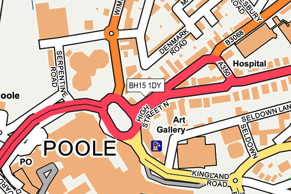
BH15 1DY is located in the Poole Town electoral ward, within the unitary authority of Bournemouth, Christchurch and Poole and the English Parliamentary constituency of Poole. The Sub Integrated Care Board (ICB) Location is NHS Dorset ICB - 11J and the police force is Dorset. This postcode has been in use since January 1980.


GetTheData
Source: OS OpenMap – Local (Ordnance Survey)
Source: OS VectorMap District (Ordnance Survey)
Licence: Open Government Licence (requires attribution)
| Easting | 401547 |
| Northing | 91104 |
| Latitude | 50.719551 |
| Longitude | -1.979443 |
GetTheData
Source: Open Postcode Geo
Licence: Open Government Licence
| Country | England |
| Postcode District | BH15 |
| ➜ BH15 open data dashboard ➜ See where BH15 is on a map ➜ Where is Poole? | |
GetTheData
Source: Land Registry Price Paid Data
Licence: Open Government Licence
Elevation or altitude of BH15 1DY as distance above sea level:
| Metres | Feet | |
|---|---|---|
| Elevation | 10m | 33ft |
Elevation is measured from the approximate centre of the postcode, to the nearest point on an OS contour line from OS Terrain 50, which has contour spacing of ten vertical metres.
➜ How high above sea level am I? Find the elevation of your current position using your device's GPS.
GetTheData
Source: Open Postcode Elevation
Licence: Open Government Licence
| Ward | Poole Town |
| Constituency | Poole |
GetTheData
Source: ONS Postcode Database
Licence: Open Government Licence
| January 2024 | Violence and sexual offences | On or near Kingland Road | 297m |
| December 2023 | Anti-social behaviour | On or near Kingland Road | 297m |
| December 2023 | Anti-social behaviour | On or near Kingland Road | 297m |
| ➜ Get more crime data in our Crime section | |||
GetTheData
Source: data.police.uk
Licence: Open Government Licence
| Barclays Set Down Only (Wimborne Road) | Poole | 38m |
| The George (High Street North) | Poole | 41m |
| The George | Poole | 54m |
| Barclays (Wimborne Road) | Poole | 99m |
| Lighthouse (Seldown Lane) | Poole | 124m |
| Poole Station | 0.3km |
| Parkstone (Dorset) Station | 2.3km |
| Hamworthy Station | 2.9km |
GetTheData
Source: NaPTAN
Licence: Open Government Licence
GetTheData
Source: ONS Postcode Database
Licence: Open Government Licence


➜ Get more ratings from the Food Standards Agency
GetTheData
Source: Food Standards Agency
Licence: FSA terms & conditions
| Last Collection | |||
|---|---|---|---|
| Location | Mon-Fri | Sat | Distance |
| Longfleet P.o. | 18:30 | 13:30 | 103m |
| Elizabeth Road | 17:30 | 12:00 | 183m |
| Parkstone Road | 17:30 | 12:00 | 227m |
GetTheData
Source: Dracos
Licence: Creative Commons Attribution-ShareAlike
| Facility | Distance |
|---|---|
| Poole Sports Centre (Closed) Dolphin Centre, Poole Sports Hall, Studio, Health and Fitness Gym, Squash Courts | 133m |
| Poole (Dolphin) Leisure Centre Kingland Road, Poole Swimming Pool, Health and Fitness Gym, Studio | 395m |
| Anytime Fitness (Poole) Lifeboat Quay, Lifeboat Quay, Poole Health and Fitness Gym | 430m |
GetTheData
Source: Active Places
Licence: Open Government Licence
| School | Phase of Education | Distance |
|---|---|---|
| Old Town Infant School and Nursery Green Road, Poole, BH15 1QB | Primary | 518m |
| Poole High School Wimborne Road, Poole, BH15 2BW | Secondary | 631m |
| Longfleet Church of England Primary School Jolliffe Avenue, Poole, BH15 2HF | Primary | 759m |
GetTheData
Source: Edubase
Licence: Open Government Licence
The below table lists the International Territorial Level (ITL) codes (formerly Nomenclature of Territorial Units for Statistics (NUTS) codes) and Local Administrative Units (LAU) codes for BH15 1DY:
| ITL 1 Code | Name |
|---|---|
| TLK | South West (England) |
| ITL 2 Code | Name |
| TLK2 | Dorset and Somerset |
| ITL 3 Code | Name |
| TLK24 | Bournemouth, Christchurch and Poole |
| LAU 1 Code | Name |
| E06000058 | Bournemouth, Christchurch and Poole |
GetTheData
Source: ONS Postcode Directory
Licence: Open Government Licence
The below table lists the Census Output Area (OA), Lower Layer Super Output Area (LSOA), and Middle Layer Super Output Area (MSOA) for BH15 1DY:
| Code | Name | |
|---|---|---|
| OA | E00078220 | |
| LSOA | E01015468 | Poole 015D |
| MSOA | E02003208 | Poole 015 |
GetTheData
Source: ONS Postcode Directory
Licence: Open Government Licence
| BH15 1DX | High Street North | 85m |
| BH15 2BU | Wimborne Road | 113m |
| BH15 2DB | Denmark Road | 115m |
| BH15 2HN | Longfleet Road | 128m |
| BH15 2HT | Longfleet Road | 139m |
| BH15 2BT | Serpentine Road | 184m |
| BH15 2DG | Denmark Lane | 195m |
| BH15 2HL | Longfleet Road | 203m |
| BH15 2DH | Elizabeth Road | 208m |
| BH15 2FL | Wimborne Road | 214m |
GetTheData
Source: Open Postcode Geo; Land Registry Price Paid Data
Licence: Open Government Licence