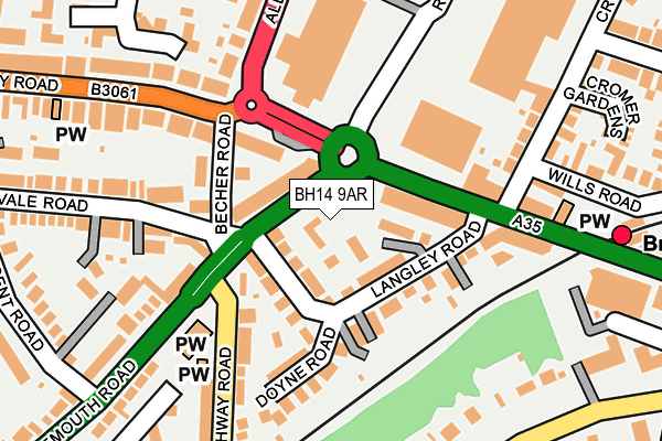
BH14 9AR is located in the Penn Hill electoral ward, within the unitary authority of Bournemouth, Christchurch and Poole and the English Parliamentary constituency of Poole. The Sub Integrated Care Board (ICB) Location is NHS Dorset ICB - 11J and the police force is Dorset. This postcode has been in use since January 1980.


GetTheData
Source: OS OpenMap – Local (Ordnance Survey)
Source: OS VectorMap District (Ordnance Survey)
Licence: Open Government Licence (requires attribution)
| Easting | 405489 |
| Northing | 91956 |
| Latitude | 50.727188 |
| Longitude | -1.923588 |
GetTheData
Source: Open Postcode Geo
Licence: Open Government Licence
| Country | England |
| Postcode District | BH14 |
| ➜ BH14 open data dashboard ➜ See where BH14 is on a map ➜ Where is Poole? | |
GetTheData
Source: Land Registry Price Paid Data
Licence: Open Government Licence
Elevation or altitude of BH14 9AR as distance above sea level:
| Metres | Feet | |
|---|---|---|
| Elevation | 50m | 164ft |
Elevation is measured from the approximate centre of the postcode, to the nearest point on an OS contour line from OS Terrain 50, which has contour spacing of ten vertical metres.
➜ How high above sea level am I? Find the elevation of your current position using your device's GPS.
GetTheData
Source: Open Postcode Elevation
Licence: Open Government Licence
| Ward | Penn Hill |
| Constituency | Poole |
GetTheData
Source: ONS Postcode Database
Licence: Open Government Licence
| January 2024 | Violence and sexual offences | On or near Parking Area | 234m |
| January 2024 | Violence and sexual offences | On or near Lodge Close | 302m |
| January 2024 | Violence and sexual offences | On or near Supermarket | 457m |
| ➜ Get more crime data in our Crime section | |||
GetTheData
Source: data.police.uk
Licence: Open Government Licence
| Branksome Station (Poole Road) | Branksome | 95m |
| Branksome Station (Poole Road) | Branksome | 115m |
| Homebase (Alder Road) | Branksome | 146m |
| Homebase (Alder Road) | Branksome | 150m |
| Cromer Road | Branksome | 179m |
| Branksome Station | 0.3km |
| Parkstone (Dorset) Station | 1.8km |
| Bournemouth Station | 4.2km |
GetTheData
Source: NaPTAN
Licence: Open Government Licence
GetTheData
Source: ONS Postcode Database
Licence: Open Government Licence


➜ Get more ratings from the Food Standards Agency
GetTheData
Source: Food Standards Agency
Licence: FSA terms & conditions
| Last Collection | |||
|---|---|---|---|
| Location | Mon-Fri | Sat | Distance |
| 451 Poole Road | 17:30 | 11:30 | 76m |
| Ashley Raod East P.o. | 17:30 | 12:00 | 228m |
| St Aldhelms Road | 17:30 | 12:30 | 343m |
GetTheData
Source: Dracos
Licence: Creative Commons Attribution-ShareAlike
| Facility | Distance |
|---|---|
| Everlast Gyms (Poole) Commerce Centre, Cromer Road, Poole Health and Fitness Gym, Swimming Pool, Studio | 430m |
| Victoria Education Centre Lindsay Road, Poole Sports Hall, Swimming Pool | 435m |
| Branksome Recreation Ground Recreation Road, Poole Grass Pitches | 708m |
GetTheData
Source: Active Places
Licence: Open Government Licence
| School | Phase of Education | Distance |
|---|---|---|
| Victoria Education Centre 12 Lindsay Road, Branksome Park, Poole, BH13 6AS | Not applicable | 435m |
| Heatherlands Primary School Library Road, Parkstone, Poole, BH12 2BG | Primary | 535m |
| Courthill Infant School Courthill Road, Parkstone, Poole, BH14 9HL | Primary | 859m |
GetTheData
Source: Edubase
Licence: Open Government Licence
The below table lists the International Territorial Level (ITL) codes (formerly Nomenclature of Territorial Units for Statistics (NUTS) codes) and Local Administrative Units (LAU) codes for BH14 9AR:
| ITL 1 Code | Name |
|---|---|
| TLK | South West (England) |
| ITL 2 Code | Name |
| TLK2 | Dorset and Somerset |
| ITL 3 Code | Name |
| TLK24 | Bournemouth, Christchurch and Poole |
| LAU 1 Code | Name |
| E06000058 | Bournemouth, Christchurch and Poole |
GetTheData
Source: ONS Postcode Directory
Licence: Open Government Licence
The below table lists the Census Output Area (OA), Lower Layer Super Output Area (LSOA), and Middle Layer Super Output Area (MSOA) for BH14 9AR:
| Code | Name | |
|---|---|---|
| OA | E00077872 | |
| LSOA | E01015402 | Poole 018A |
| MSOA | E02003211 | Poole 018 |
GetTheData
Source: ONS Postcode Directory
Licence: Open Government Licence
| BH14 9AD | Langley Road | 50m |
| BH14 9AL | Bournemouth Road | 51m |
| BH14 9BS | Ashley Road | 77m |
| BH12 1DH | Poole Road | 77m |
| BH14 9AX | Becher Road | 83m |
| BH14 9AA | Langley Road | 110m |
| BH14 9AB | Langley Road | 126m |
| BH12 1DG | Poole Road | 144m |
| BH14 9AF | Doyne Road | 166m |
| BH12 1NA | Cromer Road | 188m |
GetTheData
Source: Open Postcode Geo; Land Registry Price Paid Data
Licence: Open Government Licence