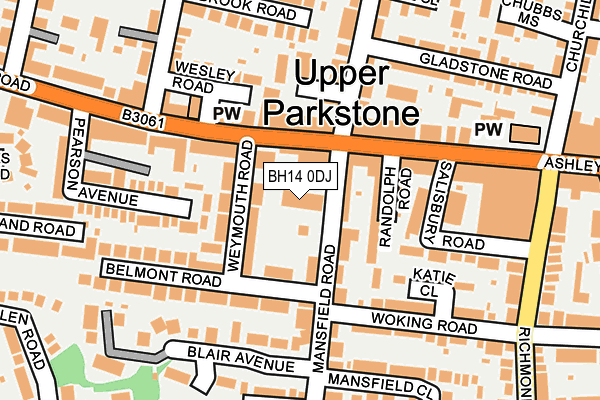
BH14 0DJ is located in the Parkstone electoral ward, within the unitary authority of Bournemouth, Christchurch and Poole and the English Parliamentary constituency of Poole. The Sub Integrated Care Board (ICB) Location is NHS Dorset ICB - 11J and the police force is Dorset. This postcode has been in use since January 1980.


GetTheData
Source: OS OpenMap – Local (Ordnance Survey)
Source: OS VectorMap District (Ordnance Survey)
Licence: Open Government Licence (requires attribution)
| Easting | 404155 |
| Northing | 92098 |
| Latitude | 50.728487 |
| Longitude | -1.942496 |
GetTheData
Source: Open Postcode Geo
Licence: Open Government Licence
| Country | England |
| Postcode District | BH14 |
| ➜ BH14 open data dashboard ➜ See where BH14 is on a map ➜ Where is Poole? | |
GetTheData
Source: Land Registry Price Paid Data
Licence: Open Government Licence
Elevation or altitude of BH14 0DJ as distance above sea level:
| Metres | Feet | |
|---|---|---|
| Elevation | 60m | 197ft |
Elevation is measured from the approximate centre of the postcode, to the nearest point on an OS contour line from OS Terrain 50, which has contour spacing of ten vertical metres.
➜ How high above sea level am I? Find the elevation of your current position using your device's GPS.
GetTheData
Source: Open Postcode Elevation
Licence: Open Government Licence
| Ward | Parkstone |
| Constituency | Poole |
GetTheData
Source: ONS Postcode Database
Licence: Open Government Licence
| October 2023 | Shoplifting | On or near Carlton Grove | 481m |
| October 2023 | Violence and sexual offences | On or near Carlton Grove | 481m |
| October 2023 | Shoplifting | On or near Carlton Grove | 481m |
| ➜ Get more crime data in our Crime section | |||
GetTheData
Source: data.police.uk
Licence: Open Government Licence
| Uppleby Road (Ashley Road) | Parkstone | 108m |
| Salisbury Road | Parkstone | 139m |
| Uppleby Road (Ashley Road) | Parkstone | 190m |
| St Johns Church (Ashley Road) | Parkstone | 201m |
| St Johns Church | Parkstone | 215m |
| Parkstone (Dorset) Station | 0.7km |
| Branksome Station | 1.6km |
| Poole Station | 3.1km |
GetTheData
Source: NaPTAN
Licence: Open Government Licence
GetTheData
Source: ONS Postcode Database
Licence: Open Government Licence


➜ Get more ratings from the Food Standards Agency
GetTheData
Source: Food Standards Agency
Licence: FSA terms & conditions
| Last Collection | |||
|---|---|---|---|
| Location | Mon-Fri | Sat | Distance |
| Heatherland P.o. | 17:30 | 11:30 | 87m |
| 386 Ashley Road | 17:30 | 11:30 | 161m |
| 77 Bournemouth Road | 17:30 | 12:00 | 374m |
GetTheData
Source: Dracos
Licence: Creative Commons Attribution-ShareAlike
| Facility | Distance |
|---|---|
| Livingstone Road Junior School Livingstone Road, Poole Sports Hall, Grass Pitches | 748m |
| Images Health And Fitness Club (Closed) Parr Street, Poole Health and Fitness Gym, Studio | 959m |
| Haskells Recreation Ground Ringwood Road, Poole Grass Pitches | 964m |
GetTheData
Source: Active Places
Licence: Open Government Licence
| School | Phase of Education | Distance |
|---|---|---|
| Courthill Infant School Courthill Road, Parkstone, Poole, BH14 9HL | Primary | 593m |
| Livingstone Road Infant School Livingstone Road, Parkstone, Poole, BH12 3DT | Primary | 653m |
| Livingstone Road Junior School Livingstone Road, Parkstone, Poole, BH12 3DX | Primary | 748m |
GetTheData
Source: Edubase
Licence: Open Government Licence
The below table lists the International Territorial Level (ITL) codes (formerly Nomenclature of Territorial Units for Statistics (NUTS) codes) and Local Administrative Units (LAU) codes for BH14 0DJ:
| ITL 1 Code | Name |
|---|---|
| TLK | South West (England) |
| ITL 2 Code | Name |
| TLK2 | Dorset and Somerset |
| ITL 3 Code | Name |
| TLK24 | Bournemouth, Christchurch and Poole |
| LAU 1 Code | Name |
| E06000058 | Bournemouth, Christchurch and Poole |
GetTheData
Source: ONS Postcode Directory
Licence: Open Government Licence
The below table lists the Census Output Area (OA), Lower Layer Super Output Area (LSOA), and Middle Layer Super Output Area (MSOA) for BH14 0DJ:
| Code | Name | |
|---|---|---|
| OA | E00078151 | |
| LSOA | E01015454 | Poole 017C |
| MSOA | E02003210 | Poole 017 |
GetTheData
Source: ONS Postcode Directory
Licence: Open Government Licence
| BH14 0AT | Ashley Road | 50m |
| BH14 0DS | Weymouth Road | 51m |
| BH14 0DD | Mansfield Road | 53m |
| BH14 0DR | Randolph Road | 75m |
| BH14 0AS | Ashley Road | 76m |
| BH14 0AD | Ashley Road | 98m |
| BH14 0AR | Ashley Road | 123m |
| BH12 3BJ | Consort Close | 124m |
| BH14 0DF | Mansfield Road | 126m |
| BH14 0AA | Ashley Road | 131m |
GetTheData
Source: Open Postcode Geo; Land Registry Price Paid Data
Licence: Open Government Licence