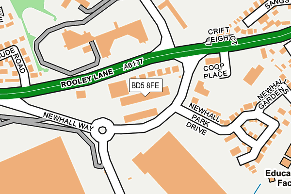
BD5 8FE is located in the Tong electoral ward, within the metropolitan district of Bradford and the English Parliamentary constituency of Bradford South. The Sub Integrated Care Board (ICB) Location is NHS West Yorkshire ICB - 36J and the police force is West Yorkshire. This postcode has been in use since October 2016.


GetTheData
Source: OS OpenMap – Local (Ordnance Survey)
Source: OS VectorMap District (Ordnance Survey)
Licence: Open Government Licence (requires attribution)
| Easting | 417169 |
| Northing | 430211 |
| Latitude | 53.767980 |
| Longitude | -1.741013 |
GetTheData
Source: Open Postcode Geo
Licence: Open Government Licence
| Country | England |
| Postcode District | BD5 |
| ➜ BD5 open data dashboard ➜ See where BD5 is on a map ➜ Where is Bradford? | |
GetTheData
Source: Land Registry Price Paid Data
Licence: Open Government Licence
Elevation or altitude of BD5 8FE as distance above sea level:
| Metres | Feet | |
|---|---|---|
| Elevation | 200m | 656ft |
Elevation is measured from the approximate centre of the postcode, to the nearest point on an OS contour line from OS Terrain 50, which has contour spacing of ten vertical metres.
➜ How high above sea level am I? Find the elevation of your current position using your device's GPS.
GetTheData
Source: Open Postcode Elevation
Licence: Open Government Licence
| Ward | Tong |
| Constituency | Bradford South |
GetTheData
Source: ONS Postcode Database
Licence: Open Government Licence
| June 2022 | Violence and sexual offences | On or near Rooley Lane | 163m |
| June 2022 | Anti-social behaviour | On or near Rooley Lane | 163m |
| June 2022 | Drugs | On or near Bude Road | 285m |
| ➜ Get more crime data in our Crime section | |||
GetTheData
Source: data.police.uk
Licence: Open Government Licence
| Rooley Lane Bude Rd (Rooley Lane) | West Bowling | 122m |
| Rooley Lane Bude Rd (Rooley Lane) | West Bowling | 160m |
| Rooley Lane Croft Leigh Court (Rooley Lane) | Bierley | 246m |
| Rooley Lane Sangster Wy (Rooley Lane) | Bierley | 333m |
| Rooley Lane | West Bowling | 356m |
| Low Moor Station | 2.2km |
| Bradford Interchange Station | 2.6km |
| Bradford Forster Square Station | 3.3km |
GetTheData
Source: NaPTAN
Licence: Open Government Licence
GetTheData
Source: ONS Postcode Database
Licence: Open Government Licence


➜ Get more ratings from the Food Standards Agency
GetTheData
Source: Food Standards Agency
Licence: FSA terms & conditions
| Last Collection | |||
|---|---|---|---|
| Location | Mon-Fri | Sat | Distance |
| 100 Parkway | 17:30 | 12:00 | 418m |
| Bierley Church | 18:15 | 13:15 | 617m |
| Bierley P.o. Box | 18:15 | 12:00 | 709m |
GetTheData
Source: Dracos
Licence: Creative Commons Attribution-ShareAlike
| Facility | Distance |
|---|---|
| West Bowling Golf Club (Closed) Newall Hall, Rooley Lane, Bradford Golf | 143m |
| Newhall Park Primary School Newhall Road, Bradford Sports Hall, Grass Pitches | 342m |
| Transforming Lives For Good Hope Park, Bradford Health and Fitness Gym, Sports Hall | 655m |
GetTheData
Source: Active Places
Licence: Open Government Licence
| School | Phase of Education | Distance |
|---|---|---|
| Newhall Park Primary School Newhall Road, Bierley, Bradford, BD4 6AF | Primary | 483m |
| St Matthew's CofE Primary School and Nursery Ivy House Road, Bradford, BD5 8FG | Primary | 834m |
| Park Aspire Avenue Road, West Bowling, Bradford, BD5 8DB | Not applicable | 932m |
GetTheData
Source: Edubase
Licence: Open Government Licence
The below table lists the International Territorial Level (ITL) codes (formerly Nomenclature of Territorial Units for Statistics (NUTS) codes) and Local Administrative Units (LAU) codes for BD5 8FE:
| ITL 1 Code | Name |
|---|---|
| TLE | Yorkshire and The Humber |
| ITL 2 Code | Name |
| TLE4 | West Yorkshire |
| ITL 3 Code | Name |
| TLE41 | Bradford |
| LAU 1 Code | Name |
| E08000032 | Bradford |
GetTheData
Source: ONS Postcode Directory
Licence: Open Government Licence
The below table lists the Census Output Area (OA), Lower Layer Super Output Area (LSOA), and Middle Layer Super Output Area (MSOA) for BD5 8FE:
| Code | Name | |
|---|---|---|
| OA | E00054532 | |
| LSOA | E01010818 | Bradford 057E |
| MSOA | E02002239 | Bradford 057 |
GetTheData
Source: ONS Postcode Directory
Licence: Open Government Licence
| BD5 8LB | Rooley Lane | 94m |
| BD5 8FA | Newhall Park Drive | 103m |
| BD5 8LJ | Yorkshire Drive | 179m |
| BD5 8BR | Newhall Park Drive | 204m |
| BD5 8FB | The Fairway | 225m |
| BD5 8LH | Croft Leigh Court | 228m |
| BD5 8JZ | Rooley Lane | 297m |
| BD5 8LA | Bude Road | 303m |
| BD5 8DU | Newhall Gardens | 307m |
| BD5 8LF | Sangster Way | 332m |
GetTheData
Source: Open Postcode Geo; Land Registry Price Paid Data
Licence: Open Government Licence