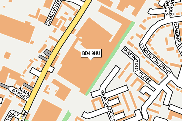
BD4 9HU is located in the Tong electoral ward, within the metropolitan district of Bradford and the English Parliamentary constituency of Bradford South. The Sub Integrated Care Board (ICB) Location is NHS West Yorkshire ICB - 36J and the police force is West Yorkshire. This postcode has been in use since July 2006.


GetTheData
Source: OS OpenMap – Local (Ordnance Survey)
Source: OS VectorMap District (Ordnance Survey)
Licence: Open Government Licence (requires attribution)
| Easting | 418851 |
| Northing | 431604 |
| Latitude | 53.780428 |
| Longitude | -1.715408 |
GetTheData
Source: Open Postcode Geo
Licence: Open Government Licence
| Country | England |
| Postcode District | BD4 |
| ➜ BD4 open data dashboard ➜ See where BD4 is on a map ➜ Where is Bradford? | |
GetTheData
Source: Land Registry Price Paid Data
Licence: Open Government Licence
Elevation or altitude of BD4 9HU as distance above sea level:
| Metres | Feet | |
|---|---|---|
| Elevation | 190m | 623ft |
Elevation is measured from the approximate centre of the postcode, to the nearest point on an OS contour line from OS Terrain 50, which has contour spacing of ten vertical metres.
➜ How high above sea level am I? Find the elevation of your current position using your device's GPS.
GetTheData
Source: Open Postcode Elevation
Licence: Open Government Licence
| Ward | Tong |
| Constituency | Bradford South |
GetTheData
Source: ONS Postcode Database
Licence: Open Government Licence
| January 2024 | Shoplifting | On or near Cutler Place | 335m |
| January 2024 | Violence and sexual offences | On or near Cutler Place | 335m |
| January 2024 | Violence and sexual offences | On or near Haslemere Close | 438m |
| ➜ Get more crime data in our Crime section | |||
GetTheData
Source: data.police.uk
Licence: Open Government Licence
| The Moorfield Ph (Cutler Heights Lane) | Cutler Heights | 117m |
| The Moorfield Ph (Cutler Heights Lane) | Cutler Heights | 127m |
| Holme Wood Road Dulverton Grove (Holme Wood Road) | Holme Wood | 332m |
| Tyersal Lane Dick Ln (Tyersal Lane) | Cutler Heights | 340m |
| Holme Wood Rd Sandmead Close (Holme Wood Road) | Holme Wood | 342m |
| Bradford Interchange Station | 2.5km |
| Bradford Forster Square Station | 3.1km |
| New Pudsey Station | 3.5km |
GetTheData
Source: NaPTAN
Licence: Open Government Licence
GetTheData
Source: ONS Postcode Database
Licence: Open Government Licence


➜ Get more ratings from the Food Standards Agency
GetTheData
Source: Food Standards Agency
Licence: FSA terms & conditions
| Last Collection | |||
|---|---|---|---|
| Location | Mon-Fri | Sat | Distance |
| Pitts Street | 18:00 | 10:00 | 119m |
| Challenge Way | 18:00 | 10:00 | 235m |
| Holmewood P.o. Box | 17:00 | 11:45 | 365m |
GetTheData
Source: Dracos
Licence: Creative Commons Attribution-ShareAlike
| Facility | Distance |
|---|---|
| Laisterdyke Cricket And Athletic Club Broad Lane, Bradford Grass Pitches | 503m |
| Tfd Youth Centre Broadstone Way, Bradford Sports Hall, Health and Fitness Gym, Grass Pitches | 503m |
| Bradford Forster Academy Fenby Avenue, Bradford Grass Pitches, Sports Hall | 604m |
GetTheData
Source: Active Places
Licence: Open Government Licence
| School | Phase of Education | Distance |
|---|---|---|
| Knowleswood Primary School Knowles Lane, Bradford, BD4 9AE | Primary | 597m |
| Bradford Forster Academy Fenby Avenue, Bradford, BD4 8RG | Secondary | 604m |
| Carrwood Primary School Eversley Drive, Holmewood, Bradford, BD4 0EQ | Primary | 683m |
GetTheData
Source: Edubase
Licence: Open Government Licence
The below table lists the International Territorial Level (ITL) codes (formerly Nomenclature of Territorial Units for Statistics (NUTS) codes) and Local Administrative Units (LAU) codes for BD4 9HU:
| ITL 1 Code | Name |
|---|---|
| TLE | Yorkshire and The Humber |
| ITL 2 Code | Name |
| TLE4 | West Yorkshire |
| ITL 3 Code | Name |
| TLE41 | Bradford |
| LAU 1 Code | Name |
| E08000032 | Bradford |
GetTheData
Source: ONS Postcode Directory
Licence: Open Government Licence
The below table lists the Census Output Area (OA), Lower Layer Super Output Area (LSOA), and Middle Layer Super Output Area (MSOA) for BD4 9HU:
| Code | Name | |
|---|---|---|
| OA | E00053562 | |
| LSOA | E01010614 | Bradford 046D |
| MSOA | E02002228 | Bradford 046 |
GetTheData
Source: ONS Postcode Directory
Licence: Open Government Licence
| BD4 9HZ | Cutler Heights Lane | 109m |
| BD4 9JJ | Pitts Street | 143m |
| BD4 9EP | Kenton Way | 156m |
| BD4 9JG | Cutler Heights Lane | 164m |
| BD4 9JH | Eldon Place | 165m |
| BD4 9HY | Cutler Heights Lane | 178m |
| BD4 9ET | Grayswood Drive | 192m |
| BD4 9ES | Grayswood Drive | 193m |
| BD4 9EX | Farringdon Close | 194m |
| BD4 9HA | Lymington Drive | 203m |
GetTheData
Source: Open Postcode Geo; Land Registry Price Paid Data
Licence: Open Government Licence