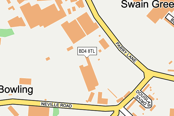
BD4 8TL is located in the Bowling and Barkerend electoral ward, within the metropolitan district of Bradford and the English Parliamentary constituency of Bradford East. The Sub Integrated Care Board (ICB) Location is NHS West Yorkshire ICB - 36J and the police force is West Yorkshire. This postcode has been in use since January 1980.


GetTheData
Source: OS OpenMap – Local (Ordnance Survey)
Source: OS VectorMap District (Ordnance Survey)
Licence: Open Government Licence (requires attribution)
| Easting | 418137 |
| Northing | 432082 |
| Latitude | 53.784749 |
| Longitude | -1.726215 |
GetTheData
Source: Open Postcode Geo
Licence: Open Government Licence
| Country | England |
| Postcode District | BD4 |
| ➜ BD4 open data dashboard ➜ See where BD4 is on a map ➜ Where is Bradford? | |
GetTheData
Source: Land Registry Price Paid Data
Licence: Open Government Licence
Elevation or altitude of BD4 8TL as distance above sea level:
| Metres | Feet | |
|---|---|---|
| Elevation | 170m | 558ft |
Elevation is measured from the approximate centre of the postcode, to the nearest point on an OS contour line from OS Terrain 50, which has contour spacing of ten vertical metres.
➜ How high above sea level am I? Find the elevation of your current position using your device's GPS.
GetTheData
Source: Open Postcode Elevation
Licence: Open Government Licence
| Ward | Bowling And Barkerend |
| Constituency | Bradford East |
GetTheData
Source: ONS Postcode Database
Licence: Open Government Licence
| June 2022 | Vehicle crime | On or near Douglas Drive | 231m |
| June 2022 | Criminal damage and arson | On or near Douglas Road | 261m |
| June 2022 | Criminal damage and arson | On or near Douglas Road | 261m |
| ➜ Get more crime data in our Crime section | |||
GetTheData
Source: data.police.uk
Licence: Open Government Licence
| Bowling Back Lane Parry Ln (Bowling Back Lane) | Cutler Heights | 240m |
| Bowling Back Lane Parry Ln (Bowling Back Lane) | Cutler Heights | 259m |
| Bowling Back Lane Swain Green (Bowling Back Lane) | Cutler Heights | 304m |
| Bowling Back Lane Mount St (Bowling Back Lane) | Cutler Heights | 319m |
| Bowling Back Lane Mount St (Bowling Back Lane) | Cutler Heights | 340m |
| Bradford Interchange Station | 1.7km |
| Bradford Forster Square Station | 2.2km |
| New Pudsey Station | 3.7km |
GetTheData
Source: NaPTAN
Licence: Open Government Licence
GetTheData
Source: ONS Postcode Database
Licence: Open Government Licence


➜ Get more ratings from the Food Standards Agency
GetTheData
Source: Food Standards Agency
Licence: FSA terms & conditions
| Last Collection | |||
|---|---|---|---|
| Location | Mon-Fri | Sat | Distance |
| 15 Parry Lane | 18:00 | 10:00 | 193m |
| Broad Lane Business Box | 18:30 | 12:30 | 499m |
| St Johns P.o. Box | 18:30 | 11:45 | 576m |
GetTheData
Source: Dracos
Licence: Creative Commons Attribution-ShareAlike
| Facility | Distance |
|---|---|
| Dudley Hill Arlfc Lower Lane, Bradford Grass Pitches | 181m |
| Lower Fields Primary School Fenby Avenue, Bradford Grass Pitches | 482m |
| Laisterdyke Cricket And Athletic Club Broad Lane, Bradford Grass Pitches | 570m |
GetTheData
Source: Active Places
Licence: Open Government Licence
| School | Phase of Education | Distance |
|---|---|---|
| Lower Fields Primary Academy Fenby Avenue, Bradford, BD4 8RG | Primary | 482m |
| Bradford Forster Academy Fenby Avenue, Bradford, BD4 8RG | Secondary | 578m |
| Fearnville Primary School Fearnville Drive, Off Sticker Lane, Bradford, BD4 8DX | Primary | 744m |
GetTheData
Source: Edubase
Licence: Open Government Licence
The below table lists the International Territorial Level (ITL) codes (formerly Nomenclature of Territorial Units for Statistics (NUTS) codes) and Local Administrative Units (LAU) codes for BD4 8TL:
| ITL 1 Code | Name |
|---|---|
| TLE | Yorkshire and The Humber |
| ITL 2 Code | Name |
| TLE4 | West Yorkshire |
| ITL 3 Code | Name |
| TLE41 | Bradford |
| LAU 1 Code | Name |
| E08000032 | Bradford |
GetTheData
Source: ONS Postcode Directory
Licence: Open Government Licence
The below table lists the Census Output Area (OA), Lower Layer Super Output Area (LSOA), and Middle Layer Super Output Area (MSOA) for BD4 8TL:
| Code | Name | |
|---|---|---|
| OA | E00053550 | |
| LSOA | E01010609 | Bradford 046A |
| MSOA | E02002228 | Bradford 046 |
GetTheData
Source: ONS Postcode Directory
Licence: Open Government Licence
| BD4 8TJ | Parry Lane | 122m |
| BD4 8QJ | Lower Lane | 219m |
| BD4 8SS | Bowling Back Lane | 234m |
| BD4 8SY | Bowling Back Lane | 238m |
| BD4 8QL | Douglas Drive | 284m |
| BD4 8TA | Mount Street | 314m |
| BD4 8QF | Buller Street | 336m |
| BD4 8QH | Parry Lane | 338m |
| BD4 8RS | Sticker Lane | 367m |
| BD4 8QQ | Sticker Lane | 369m |
GetTheData
Source: Open Postcode Geo; Land Registry Price Paid Data
Licence: Open Government Licence