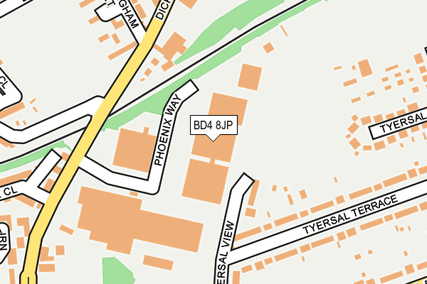
BD4 8JP is located in the Pudsey electoral ward, within the metropolitan district of Leeds and the English Parliamentary constituency of Pudsey. The Sub Integrated Care Board (ICB) Location is NHS West Yorkshire ICB - 15F and the police force is West Yorkshire. This postcode has been in use since January 1991.


GetTheData
Source: OS OpenMap – Local (Ordnance Survey)
Source: OS VectorMap District (Ordnance Survey)
Licence: Open Government Licence (requires attribution)
| Easting | 419364 |
| Northing | 432955 |
| Latitude | 53.792551 |
| Longitude | -1.707539 |
GetTheData
Source: Open Postcode Geo
Licence: Open Government Licence
| Country | England |
| Postcode District | BD4 |
| ➜ BD4 open data dashboard ➜ See where BD4 is on a map ➜ Where is Bradford? | |
GetTheData
Source: Land Registry Price Paid Data
Licence: Open Government Licence
Elevation or altitude of BD4 8JP as distance above sea level:
| Metres | Feet | |
|---|---|---|
| Elevation | 170m | 558ft |
Elevation is measured from the approximate centre of the postcode, to the nearest point on an OS contour line from OS Terrain 50, which has contour spacing of ten vertical metres.
➜ How high above sea level am I? Find the elevation of your current position using your device's GPS.
GetTheData
Source: Open Postcode Elevation
Licence: Open Government Licence
| Ward | Pudsey |
| Constituency | Pudsey |
GetTheData
Source: ONS Postcode Database
Licence: Open Government Licence
| December 2023 | Anti-social behaviour | On or near Back Tamworth Street | 365m |
| December 2023 | Anti-social behaviour | On or near Back Tamworth Street | 365m |
| December 2023 | Violence and sexual offences | On or near Back Tamworth Street | 365m |
| ➜ Get more crime data in our Crime section | |||
GetTheData
Source: data.police.uk
Licence: Open Government Licence
| Dick Lane Nottingham St (Dick Lane) | Tyersal | 186m |
| Dick Lane Lower Rushden Rd (Dick Lane) | Tyersal | 283m |
| Tyersal Road Tyersal View (Tyersal Road) | Tyersal | 293m |
| Tyersal Road Tyersal View (Tyersal Road) | Tyersal | 301m |
| Tyersal Green (Tyersal Road) | Tyersal | 321m |
| New Pudsey Station | 2.2km |
| Bradford Interchange Station | 2.8km |
| Bradford Forster Square Station | 3km |
GetTheData
Source: NaPTAN
Licence: Open Government Licence
GetTheData
Source: ONS Postcode Database
Licence: Open Government Licence


➜ Get more ratings from the Food Standards Agency
GetTheData
Source: Food Standards Agency
Licence: FSA terms & conditions
| Last Collection | |||
|---|---|---|---|
| Location | Mon-Fri | Sat | Distance |
| 10 - 12 Tyersal Road | 18:00 | 10:45 | 272m |
| Tyersal | 17:30 | 10:45 | 365m |
| Tyersal Avenue | 18:00 | 10:30 | 441m |
GetTheData
Source: Dracos
Licence: Creative Commons Attribution-ShareAlike
| Facility | Distance |
|---|---|
| Arkwright Street Rec Ground (Tyersal Fc) Arkwright Street, Tyersal, Bradford Grass Pitches | 355m |
| Tyersal Park Tyersal Road, Tyersal, Bradford Grass Pitches, Outdoor Tennis Courts | 600m |
| Laisterdyke Leadership Academy Thornbury Road, Bradford Grass Pitches, Sports Hall | 629m |
GetTheData
Source: Active Places
Licence: Open Government Licence
| School | Phase of Education | Distance |
|---|---|---|
| Thornbury Primary Leadership Academy Dick Lane, Bradford, BD3 7AU | Primary | 398m |
| Co-op Academy Beckfield Tyersal Walk, Tyersal, Bradford, BD4 8ER | Primary | 593m |
| Laisterdyke Leadership Academy Thornbury Road, Bradford, BD3 8HE | Secondary | 629m |
GetTheData
Source: Edubase
Licence: Open Government Licence
The below table lists the International Territorial Level (ITL) codes (formerly Nomenclature of Territorial Units for Statistics (NUTS) codes) and Local Administrative Units (LAU) codes for BD4 8JP:
| ITL 1 Code | Name |
|---|---|
| TLE | Yorkshire and The Humber |
| ITL 2 Code | Name |
| TLE4 | West Yorkshire |
| ITL 3 Code | Name |
| TLE42 | Leeds |
| LAU 1 Code | Name |
| E08000035 | Leeds |
GetTheData
Source: ONS Postcode Directory
Licence: Open Government Licence
The below table lists the Census Output Area (OA), Lower Layer Super Output Area (LSOA), and Middle Layer Super Output Area (MSOA) for BD4 8JP:
| Code | Name | |
|---|---|---|
| OA | E00058484 | |
| LSOA | E01011606 | Leeds 076D |
| MSOA | E02002405 | Leeds 076 |
GetTheData
Source: ONS Postcode Directory
Licence: Open Government Licence
| BD4 8HS | Tyersal View | 98m |
| BD3 8QD | Dick Lane | 145m |
| BD4 8HR | Tyersal Terrace | 151m |
| BD4 8HT | Tyersal View | 208m |
| BD3 8QB | Nottingham Street | 228m |
| BD4 8HN | Tyersal Grove | 246m |
| BD4 8HP | Tyersal Terrace | 262m |
| BD4 8ET | Tyersal Road | 263m |
| BD3 8PZ | Lower Rushton Road | 284m |
| BD3 8NW | New Lane | 293m |
GetTheData
Source: Open Postcode Geo; Land Registry Price Paid Data
Licence: Open Government Licence