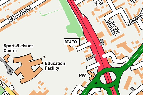
BD4 7QJ is located in the Bowling and Barkerend electoral ward, within the metropolitan district of Bradford and the English Parliamentary constituency of Bradford East. The Sub Integrated Care Board (ICB) Location is NHS West Yorkshire ICB - 36J and the police force is West Yorkshire. This postcode has been in use since January 1980.


GetTheData
Source: OS OpenMap – Local (Ordnance Survey)
Source: OS VectorMap District (Ordnance Survey)
Licence: Open Government Licence (requires attribution)
| Easting | 417925 |
| Northing | 431215 |
| Latitude | 53.776964 |
| Longitude | -1.729483 |
GetTheData
Source: Open Postcode Geo
Licence: Open Government Licence
| Country | England |
| Postcode District | BD4 |
| ➜ BD4 open data dashboard ➜ See where BD4 is on a map ➜ Where is Bradford? | |
GetTheData
Source: Land Registry Price Paid Data
Licence: Open Government Licence
Elevation or altitude of BD4 7QJ as distance above sea level:
| Metres | Feet | |
|---|---|---|
| Elevation | 200m | 656ft |
Elevation is measured from the approximate centre of the postcode, to the nearest point on an OS contour line from OS Terrain 50, which has contour spacing of ten vertical metres.
➜ How high above sea level am I? Find the elevation of your current position using your device's GPS.
GetTheData
Source: Open Postcode Elevation
Licence: Open Government Licence
| Ward | Bowling And Barkerend |
| Constituency | Bradford East |
GetTheData
Source: ONS Postcode Database
Licence: Open Government Licence
| December 2023 | Anti-social behaviour | On or near Bowling Hall Road | 492m |
| November 2023 | Anti-social behaviour | On or near Longfield Drive | 294m |
| November 2023 | Criminal damage and arson | On or near Bowling Hall Road | 492m |
| ➜ Get more crime data in our Crime section | |||
GetTheData
Source: data.police.uk
Licence: Open Government Licence
| Wakefield Rd Harcourt Street (Wakefield Road) | Dudley Hill | 86m |
| Wakefield Rd Corban Street (Wakefield Road) | Dudley Hill | 135m |
| Rooley Lane Wakefield Rd (Rooley Lane) | Dudley Hill | 173m |
| Rooley Lane Wakefield Rd (Rooley Lane) | Dudley Hill | 212m |
| Lister Avenue Wakefield Rd (Lister Avenue) | East Bowling | 245m |
| Bradford Interchange Station | 2.1km |
| Bradford Forster Square Station | 2.7km |
| Low Moor Station | 3.4km |
GetTheData
Source: NaPTAN
Licence: Open Government Licence
GetTheData
Source: ONS Postcode Database
Licence: Open Government Licence


➜ Get more ratings from the Food Standards Agency
GetTheData
Source: Food Standards Agency
Licence: FSA terms & conditions
| Last Collection | |||
|---|---|---|---|
| Location | Mon-Fri | Sat | Distance |
| 10 Lister Avenue | 18:30 | 12:30 | 248m |
| Bowling Hall Road | 18:30 | 12:30 | 323m |
| 524 Sticker Lane | 18:00 | 10:00 | 413m |
GetTheData
Source: Dracos
Licence: Creative Commons Attribution-ShareAlike
| Facility | Distance |
|---|---|
| Bradford Academy Teasdale Street, Bradford Sports Hall, Health and Fitness Gym, Grass Pitches, Artificial Grass Pitch | 204m |
| Bradford Cathedral Community College (Closed) Lister Avenue, Bradford Grass Pitches, Sports Hall | 278m |
| Lower Fields Primary School Fenby Avenue, Bradford Grass Pitches | 414m |
GetTheData
Source: Active Places
Licence: Open Government Licence
| School | Phase of Education | Distance |
|---|---|---|
| Bradford Academy Teasdale Street, Bradford, BD4 7QJ | All-through | 204m |
| Darul Uloom Dawatul Imaan Harry Street, Off Wakefield Road, Bradford, BD4 9PH | Not applicable | 336m |
| Oastlers School Flockton Road, Bradford, BD4 7RH | Not applicable | 404m |
GetTheData
Source: Edubase
Licence: Open Government Licence
The below table lists the International Territorial Level (ITL) codes (formerly Nomenclature of Territorial Units for Statistics (NUTS) codes) and Local Administrative Units (LAU) codes for BD4 7QJ:
| ITL 1 Code | Name |
|---|---|
| TLE | Yorkshire and The Humber |
| ITL 2 Code | Name |
| TLE4 | West Yorkshire |
| ITL 3 Code | Name |
| TLE41 | Bradford |
| LAU 1 Code | Name |
| E08000032 | Bradford |
GetTheData
Source: ONS Postcode Directory
Licence: Open Government Licence
The below table lists the Census Output Area (OA), Lower Layer Super Output Area (LSOA), and Middle Layer Super Output Area (MSOA) for BD4 7QJ:
| Code | Name | |
|---|---|---|
| OA | E00053576 | |
| LSOA | E01010615 | Bradford 053A |
| MSOA | E02002235 | Bradford 053 |
GetTheData
Source: ONS Postcode Directory
Licence: Open Government Licence
| BD4 7QN | Haigh Street | 60m |
| BD4 7QQ | Wakefield Road | 63m |
| BD4 7QH | Harcourt Street | 78m |
| BD4 7QE | Munster Street | 126m |
| BD4 8RH | Corban Street | 156m |
| BD4 7PZ | Dudley Street | 170m |
| BD4 7SB | Rooley Lane | 177m |
| BD4 7PU | Vestry Street | 198m |
| BD4 7PT | Wakefield Road | 211m |
| BD4 7QP | Lister Avenue | 220m |
GetTheData
Source: Open Postcode Geo; Land Registry Price Paid Data
Licence: Open Government Licence