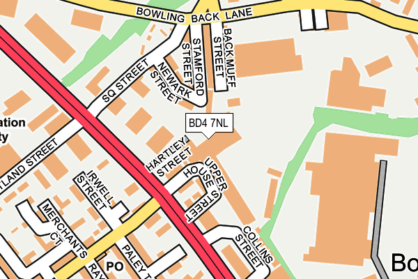
BD4 7NL is located in the Bowling and Barkerend electoral ward, within the metropolitan district of Bradford and the English Parliamentary constituency of Bradford East. The Sub Integrated Care Board (ICB) Location is NHS West Yorkshire ICB - 36J and the police force is West Yorkshire. This postcode has been in use since February 1984.


GetTheData
Source: OS OpenMap – Local (Ordnance Survey)
Source: OS VectorMap District (Ordnance Survey)
Licence: Open Government Licence (requires attribution)
| Easting | 417568 |
| Northing | 432151 |
| Latitude | 53.785389 |
| Longitude | -1.734847 |
GetTheData
Source: Open Postcode Geo
Licence: Open Government Licence
| Country | England |
| Postcode District | BD4 |
| ➜ BD4 open data dashboard ➜ See where BD4 is on a map ➜ Where is Bradford? | |
GetTheData
Source: Land Registry Price Paid Data
Licence: Open Government Licence
Elevation or altitude of BD4 7NL as distance above sea level:
| Metres | Feet | |
|---|---|---|
| Elevation | 150m | 492ft |
Elevation is measured from the approximate centre of the postcode, to the nearest point on an OS contour line from OS Terrain 50, which has contour spacing of ten vertical metres.
➜ How high above sea level am I? Find the elevation of your current position using your device's GPS.
GetTheData
Source: Open Postcode Elevation
Licence: Open Government Licence
| Ward | Bowling And Barkerend |
| Constituency | Bradford East |
GetTheData
Source: ONS Postcode Database
Licence: Open Government Licence
| January 2024 | Public order | On or near Newark Street | 99m |
| January 2024 | Violence and sexual offences | On or near Ledbury Place | 395m |
| January 2024 | Violence and sexual offences | On or near Ledbury Place | 395m |
| ➜ Get more crime data in our Crime section | |||
GetTheData
Source: data.police.uk
Licence: Open Government Licence
| Wakefield Rd Paley Road (Wakefield Road) | East Bowling | 90m |
| Wakefield Rd Paley Road (Wakefield Road) | East Bowling | 176m |
| Bowling Back Lane Hammerton St (Bowling Back Lane) | East Bowling | 180m |
| Bowling Back Lane Hammerton St (Bowling Back Lane) | East Bowling | 202m |
| Wakefield Rd Usher Street (Wakefield Road) | East Bowling | 290m |
| Bradford Interchange Station | 1.2km |
| Bradford Forster Square Station | 1.8km |
| Low Moor Station | 4.1km |
GetTheData
Source: NaPTAN
Licence: Open Government Licence
GetTheData
Source: ONS Postcode Database
Licence: Open Government Licence


➜ Get more ratings from the Food Standards Agency
GetTheData
Source: Food Standards Agency
Licence: FSA terms & conditions
| Last Collection | |||
|---|---|---|---|
| Location | Mon-Fri | Sat | Distance |
| 38 Paley Road | 18:30 | 12:45 | 222m |
| St Johns P.o. Box | 18:30 | 11:45 | 330m |
| Francis Street | 18:30 | 11:45 | 480m |
GetTheData
Source: Dracos
Licence: Creative Commons Attribution-ShareAlike
| Facility | Distance |
|---|---|
| Dudley Hill Arlfc Lower Lane, Bradford Grass Pitches | 710m |
| Bronte Girls Academy Bolling Road, Bradford Sports Hall | 720m |
| Lower Fields Primary School Fenby Avenue, Bradford Grass Pitches | 731m |
GetTheData
Source: Active Places
Licence: Open Government Licence
| School | Phase of Education | Distance |
|---|---|---|
| Bronte Girls' Academy Bolling Road, East Bowling, Bradford, BD4 7EB | Secondary | 720m |
| Lower Fields Primary Academy Fenby Avenue, Bradford, BD4 8RG | Primary | 731m |
| Oastlers School Flockton Road, Bradford, BD4 7RH | Not applicable | 815m |
GetTheData
Source: Edubase
Licence: Open Government Licence
The below table lists the International Territorial Level (ITL) codes (formerly Nomenclature of Territorial Units for Statistics (NUTS) codes) and Local Administrative Units (LAU) codes for BD4 7NL:
| ITL 1 Code | Name |
|---|---|
| TLE | Yorkshire and The Humber |
| ITL 2 Code | Name |
| TLE4 | West Yorkshire |
| ITL 3 Code | Name |
| TLE41 | Bradford |
| LAU 1 Code | Name |
| E08000032 | Bradford |
GetTheData
Source: ONS Postcode Directory
Licence: Open Government Licence
The below table lists the Census Output Area (OA), Lower Layer Super Output Area (LSOA), and Middle Layer Super Output Area (MSOA) for BD4 7NL:
| Code | Name | |
|---|---|---|
| OA | E00053556 | |
| LSOA | E01010613 | Bradford 045B |
| MSOA | E02002227 | Bradford 045 |
GetTheData
Source: ONS Postcode Directory
Licence: Open Government Licence
| BD4 7NH | Upper House Street | 70m |
| BD4 8SB | Newark Street | 104m |
| BD4 8SD | Stamford Street | 104m |
| BD4 7NU | Square Street | 105m |
| BD4 7EW | Back Irwell Street | 127m |
| BD4 7NP | Square Street | 144m |
| BD4 8SE | Bowling Back Lane | 161m |
| BD4 7EE | Rhine Street | 163m |
| BD4 7EQ | Irwell Street | 169m |
| BD4 7NQ | Square Street | 180m |
GetTheData
Source: Open Postcode Geo; Land Registry Price Paid Data
Licence: Open Government Licence