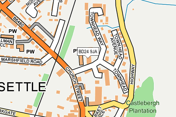
BD24 9JA is located in the Settle & Penyghent electoral ward, within the unitary authority of North Yorkshire and the English Parliamentary constituency of Skipton and Ripon. The Sub Integrated Care Board (ICB) Location is NHS West Yorkshire ICB - 36J and the police force is North Yorkshire. This postcode has been in use since April 1987.


GetTheData
Source: OS OpenMap – Local (Ordnance Survey)
Source: OS VectorMap District (Ordnance Survey)
Licence: Open Government Licence (requires attribution)
| Easting | 381977 |
| Northing | 463880 |
| Latitude | 54.070534 |
| Longitude | -2.276903 |
GetTheData
Source: Open Postcode Geo
Licence: Open Government Licence
| Country | England |
| Postcode District | BD24 |
| ➜ BD24 open data dashboard ➜ See where BD24 is on a map ➜ Where is Settle? | |
GetTheData
Source: Land Registry Price Paid Data
Licence: Open Government Licence
Elevation or altitude of BD24 9JA as distance above sea level:
| Metres | Feet | |
|---|---|---|
| Elevation | 150m | 492ft |
Elevation is measured from the approximate centre of the postcode, to the nearest point on an OS contour line from OS Terrain 50, which has contour spacing of ten vertical metres.
➜ How high above sea level am I? Find the elevation of your current position using your device's GPS.
GetTheData
Source: Open Postcode Elevation
Licence: Open Government Licence
| Ward | Settle & Penyghent |
| Constituency | Skipton And Ripon |
GetTheData
Source: ONS Postcode Database
Licence: Open Government Licence
| January 2024 | Violence and sexual offences | On or near Parking Area | 464m |
| January 2024 | Violence and sexual offences | On or near Parking Area | 464m |
| September 2023 | Violence and sexual offences | On or near Parking Area | 464m |
| ➜ Get more crime data in our Crime section | |||
GetTheData
Source: data.police.uk
Licence: Open Government Licence
| Market Place (Church Street) | Settle | 202m |
| Market Place (Kirkgate) | Settle | 205m |
| Bridge End (Church Street) | Settle | 255m |
| Penyghent View (B6480) | Settle | 263m |
| Settle Station (Station Road) | Settle | 409m |
| Settle Station | 0.5km |
| Giggleswick Station | 2km |
GetTheData
Source: NaPTAN
Licence: Open Government Licence
GetTheData
Source: ONS Postcode Database
Licence: Open Government Licence


➜ Get more ratings from the Food Standards Agency
GetTheData
Source: Food Standards Agency
Licence: FSA terms & conditions
| Last Collection | |||
|---|---|---|---|
| Location | Mon-Fri | Sat | Distance |
| Townhead Court | 17:30 | 11:45 | 104m |
| Market Place | 17:30 | 12:00 | 202m |
| Bridge End | 17:30 | 11:45 | 294m |
GetTheData
Source: Dracos
Licence: Creative Commons Attribution-ShareAlike
| Facility | Distance |
|---|---|
| Settle Cricket Club (Marshfield Ground) Marshfield Road, Settle Grass Pitches | 247m |
| Settle Drill Hall Castlebergh Lane, Settle Sports Hall | 375m |
| Bridge End Ground Staircase Cave To Settle Bridge, Giggleswick, Settle Grass Pitches | 440m |
GetTheData
Source: Active Places
Licence: Open Government Licence
| School | Phase of Education | Distance |
|---|---|---|
| Settle Church of England Voluntary Controlled Primary School Bond Lane, Settle, BD24 9BW | Primary | 458m |
| Settle College Giggleswick, Settle, BD24 0AU | Secondary | 572m |
| Giggleswick School Giggleswick, Settle, BD24 0DE | Not applicable | 938m |
GetTheData
Source: Edubase
Licence: Open Government Licence
The below table lists the International Territorial Level (ITL) codes (formerly Nomenclature of Territorial Units for Statistics (NUTS) codes) and Local Administrative Units (LAU) codes for BD24 9JA:
| ITL 1 Code | Name |
|---|---|
| TLE | Yorkshire and The Humber |
| ITL 2 Code | Name |
| TLE2 | North Yorkshire |
| ITL 3 Code | Name |
| TLE22 | North Yorkshire CC |
| LAU 1 Code | Name |
| E07000163 | Craven |
GetTheData
Source: ONS Postcode Directory
Licence: Open Government Licence
The below table lists the Census Output Area (OA), Lower Layer Super Output Area (LSOA), and Middle Layer Super Output Area (MSOA) for BD24 9JA:
| Code | Name | |
|---|---|---|
| OA | E00140361 | |
| LSOA | E01027572 | Craven 003C |
| MSOA | E02005744 | Craven 003 |
GetTheData
Source: ONS Postcode Directory
Licence: Open Government Licence
| BD24 9RQ | Town Head Avenue | 97m |
| BD24 9JE | Church Street | 108m |
| BD24 9EG | Howsons Yard | 109m |
| BD24 9RG | Town Head Way | 116m |
| BD24 9JD | Church Street | 131m |
| BD24 9JF | Mains View | 147m |
| BD24 9EF | Market Place | 154m |
| BD24 9LW | Coachmans Cottages | 156m |
| BD24 9JG | Church Street | 161m |
| BD24 9LG | Townhead Croft | 170m |
GetTheData
Source: Open Postcode Geo; Land Registry Price Paid Data
Licence: Open Government Licence