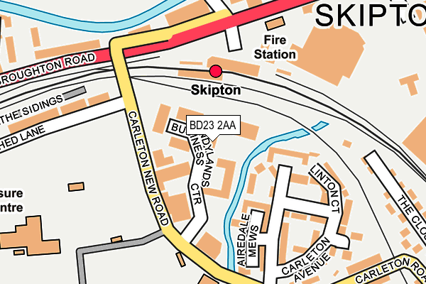
BD23 2AA lies on Sandylands Business Centre in Skipton. BD23 2AA is located in the Skipton West & West Craven electoral ward, within the unitary authority of North Yorkshire and the English Parliamentary constituency of Skipton and Ripon. The Sub Integrated Care Board (ICB) Location is NHS West Yorkshire ICB - 36J and the police force is North Yorkshire. This postcode has been in use since July 1990.


GetTheData
Source: OS OpenMap – Local (Ordnance Survey)
Source: OS VectorMap District (Ordnance Survey)
Licence: Open Government Licence (requires attribution)
| Easting | 398322 |
| Northing | 451268 |
| Latitude | 53.957513 |
| Longitude | -2.027064 |
GetTheData
Source: Open Postcode Geo
Licence: Open Government Licence
| Street | Sandylands Business Centre |
| Town/City | Skipton |
| Country | England |
| Postcode District | BD23 |
➜ See where BD23 is on a map ➜ Where is Skipton? | |
GetTheData
Source: Land Registry Price Paid Data
Licence: Open Government Licence
Elevation or altitude of BD23 2AA as distance above sea level:
| Metres | Feet | |
|---|---|---|
| Elevation | 100m | 328ft |
Elevation is measured from the approximate centre of the postcode, to the nearest point on an OS contour line from OS Terrain 50, which has contour spacing of ten vertical metres.
➜ How high above sea level am I? Find the elevation of your current position using your device's GPS.
GetTheData
Source: Open Postcode Elevation
Licence: Open Government Licence
| Ward | Skipton West & West Craven |
| Constituency | Skipton And Ripon |
GetTheData
Source: ONS Postcode Database
Licence: Open Government Licence
| Railway Station (A6069) | Skipton | 143m |
| Outside Rail Station (Broughton Road) | Skipton | 198m |
| Fire Station (Broughton Road) | Skipton | 243m |
| Clifford Court (Broughton Road) | Skipton | 289m |
| Belle Vue Mills (Broughton Road) | Skipton | 322m |
| Skipton Station | 0.2km |
| Cononley Station | 4.6km |
GetTheData
Source: NaPTAN
Licence: Open Government Licence
Estimated total energy consumption in BD23 2AA by fuel type, 2015.
| Consumption (kWh) | 170,799 |
|---|---|
| Meter count | 8 |
| Mean (kWh/meter) | 21,350 |
| Median (kWh/meter) | 14,678 |
GetTheData
Source: Postcode level gas estimates: 2015 (experimental)
Source: Postcode level electricity estimates: 2015 (experimental)
Licence: Open Government Licence
GetTheData
Source: ONS Postcode Database
Licence: Open Government Licence


➜ Get more ratings from the Food Standards Agency
GetTheData
Source: Food Standards Agency
Licence: FSA terms & conditions
| Last Collection | |||
|---|---|---|---|
| Location | Mon-Fri | Sat | Distance |
| Royal Mail | 18:30 | 13:00 | 38m |
| Skipton Do Business Box | 18:30 | 42m | |
| Skipton Railway Station | 17:45 | 12:15 | 127m |
GetTheData
Source: Dracos
Licence: Creative Commons Attribution-ShareAlike
| Risk of BD23 2AA flooding from rivers and sea | Low |
| ➜ BD23 2AA flood map | |
GetTheData
Source: Open Flood Risk by Postcode
Licence: Open Government Licence
The below table lists the International Territorial Level (ITL) codes (formerly Nomenclature of Territorial Units for Statistics (NUTS) codes) and Local Administrative Units (LAU) codes for BD23 2AA:
| ITL 1 Code | Name |
|---|---|
| TLE | Yorkshire and The Humber |
| ITL 2 Code | Name |
| TLE2 | North Yorkshire |
| ITL 3 Code | Name |
| TLE22 | North Yorkshire CC |
| LAU 1 Code | Name |
| E07000163 | Craven |
GetTheData
Source: ONS Postcode Directory
Licence: Open Government Licence
The below table lists the Census Output Area (OA), Lower Layer Super Output Area (LSOA), and Middle Layer Super Output Area (MSOA) for BD23 2AA:
| Code | Name | |
|---|---|---|
| OA | E00140404 | |
| LSOA | E01027581 | Craven 006C |
| MSOA | E02005747 | Craven 006 |
GetTheData
Source: ONS Postcode Directory
Licence: Open Government Licence
| BD23 2DE | Carleton New Road | 73m |
| BD23 2TQ | Glynwed Court | 100m |
| BD23 2TG | Eller Mews | 145m |
| BD23 2TF | Airedale Mews | 171m |
| BD23 2TH | Linton Court | 199m |
| BD23 1RX | Aireview Terrace | 223m |
| BD23 2TE | Carleton Avenue | 226m |
| BD23 1RU | Belle Vue Terrace | 273m |
| BD23 1TB | The Sidings Business Park | 290m |
| BD23 2BA | Airedale Terrace | 298m |
GetTheData
Source: Open Postcode Geo; Land Registry Price Paid Data
Licence: Open Government Licence