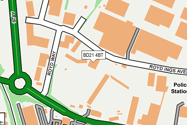
BD21 4BT is located in the Keighley Central electoral ward, within the metropolitan district of Bradford and the English Parliamentary constituency of Keighley. The Sub Integrated Care Board (ICB) Location is NHS West Yorkshire ICB - 36J and the police force is West Yorkshire. This postcode has been in use since January 2007.


GetTheData
Source: OS OpenMap – Local (Ordnance Survey)
Source: OS VectorMap District (Ordnance Survey)
Licence: Open Government Licence (requires attribution)
| Easting | 406461 |
| Northing | 442247 |
| Latitude | 53.876384 |
| Longitude | -1.903212 |
GetTheData
Source: Open Postcode Geo
Licence: Open Government Licence
| Country | England |
| Postcode District | BD21 |
| ➜ BD21 open data dashboard ➜ See where BD21 is on a map ➜ Where is Keighley? | |
GetTheData
Source: Land Registry Price Paid Data
Licence: Open Government Licence
Elevation or altitude of BD21 4BT as distance above sea level:
| Metres | Feet | |
|---|---|---|
| Elevation | 90m | 295ft |
Elevation is measured from the approximate centre of the postcode, to the nearest point on an OS contour line from OS Terrain 50, which has contour spacing of ten vertical metres.
➜ How high above sea level am I? Find the elevation of your current position using your device's GPS.
GetTheData
Source: Open Postcode Elevation
Licence: Open Government Licence
| Ward | Keighley Central |
| Constituency | Keighley |
GetTheData
Source: ONS Postcode Database
Licence: Open Government Licence
| November 2023 | Other theft | On or near Linnet Street | 492m |
| November 2023 | Criminal damage and arson | On or near Linnet Street | 492m |
| October 2023 | Burglary | On or near Linnet Street | 492m |
| ➜ Get more crime data in our Crime section | |||
GetTheData
Source: data.police.uk
Licence: Open Government Licence
| Royd Way Hard Ings Rd (Royd Way) | Eastwood | 145m |
| Royd Way Royd Ings Ave (Royd Way) | Eastwood | 149m |
| Lawkholme Lane Eric St (Lawkholme Lane) | Eastwood | 249m |
| Lawkholme Lane Eric St (Lawkholme Lane) | Eastwood | 250m |
| Royd Ings Avenue Alston Rd (Royd Ings Avenue) | Eastwood | 270m |
| Keighley Station | 0.9km |
| Steeton & Silsden Station | 3.8km |
| Crossflatts Station | 4.3km |
GetTheData
Source: NaPTAN
Licence: Open Government Licence
GetTheData
Source: ONS Postcode Database
Licence: Open Government Licence


➜ Get more ratings from the Food Standards Agency
GetTheData
Source: Food Standards Agency
Licence: FSA terms & conditions
| Last Collection | |||
|---|---|---|---|
| Location | Mon-Fri | Sat | Distance |
| Lawksholme Lane | 17:45 | 11:15 | 431m |
| East Ave | 18:00 | 12:15 | 503m |
| Victoria Park/Beeches | 17:45 | 11:15 | 663m |
GetTheData
Source: Dracos
Licence: Creative Commons Attribution-ShareAlike
| Facility | Distance |
|---|---|
| Keighley Cougars (Cougar Park) Hard Ings Road, Keighley Grass Pitches, Health and Fitness Gym | 97m |
| Keighley Cricket Ground Hard Ings Road, Keighley Grass Pitches | 146m |
| The Leisure Centre Keighley Victoria Park, Keighley Sports Hall, Swimming Pool, Health and Fitness Gym, Squash Courts, Studio | 359m |
GetTheData
Source: Active Places
Licence: Open Government Licence
| School | Phase of Education | Distance |
|---|---|---|
| Eastwood Community School Victoria Avenue, Keighley, BD21 3JL | Primary | 416m |
| Riddlesden St Mary's CofE Primary School Grange Road, Riddlesden, Keighley, BD20 5AB | Primary | 772m |
| St Anne's Catholic Primary School North Street, Keighley, BD21 3AD | Primary | 843m |
GetTheData
Source: Edubase
Licence: Open Government Licence
The below table lists the International Territorial Level (ITL) codes (formerly Nomenclature of Territorial Units for Statistics (NUTS) codes) and Local Administrative Units (LAU) codes for BD21 4BT:
| ITL 1 Code | Name |
|---|---|
| TLE | Yorkshire and The Humber |
| ITL 2 Code | Name |
| TLE4 | West Yorkshire |
| ITL 3 Code | Name |
| TLE41 | Bradford |
| LAU 1 Code | Name |
| E08000032 | Bradford |
GetTheData
Source: ONS Postcode Directory
Licence: Open Government Licence
The below table lists the Census Output Area (OA), Lower Layer Super Output Area (LSOA), and Middle Layer Super Output Area (MSOA) for BD21 4BT:
| Code | Name | |
|---|---|---|
| OA | E00054020 | |
| LSOA | E01010708 | Bradford 006C |
| MSOA | E02002188 | Bradford 006 |
GetTheData
Source: ONS Postcode Directory
Licence: Open Government Licence
| BD21 3NB | Hard Ings Road | 167m |
| BD21 3LX | Hard Ings Road | 219m |
| BD21 3LU | Lawkholme Lane | 235m |
| BD21 3LY | Byrl Street | 245m |
| BD21 3NA | Hard Ings Road | 254m |
| BD21 3LP | Caledonia Road | 267m |
| BD21 3LT | Eric Street | 272m |
| BD21 3LZ | Hyde Grove | 277m |
| BD21 3LS | Eric Street | 285m |
| BD21 3LR | Eric Street | 294m |
GetTheData
Source: Open Postcode Geo; Land Registry Price Paid Data
Licence: Open Government Licence