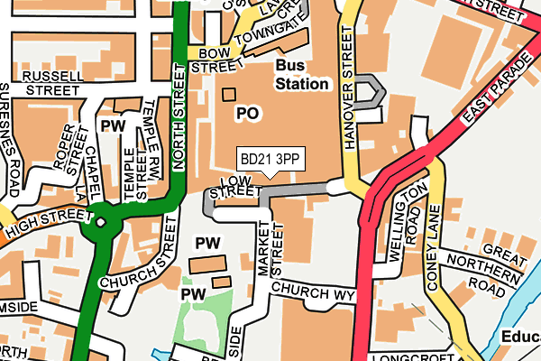
BD21 3PP lies on Low Street in Keighley. BD21 3PP is located in the Keighley Central electoral ward, within the metropolitan district of Bradford and the English Parliamentary constituency of Keighley. The Sub Integrated Care Board (ICB) Location is NHS West Yorkshire ICB - 36J and the police force is West Yorkshire. This postcode has been in use since January 1980.


GetTheData
Source: OS OpenMap – Local (Ordnance Survey)
Source: OS VectorMap District (Ordnance Survey)
Licence: Open Government Licence (requires attribution)
| Easting | 406154 |
| Northing | 441090 |
| Latitude | 53.866003 |
| Longitude | -1.907907 |
GetTheData
Source: Open Postcode Geo
Licence: Open Government Licence
| Street | Low Street |
| Town/City | Keighley |
| Country | England |
| Postcode District | BD21 |
| ➜ BD21 open data dashboard ➜ See where BD21 is on a map ➜ Where is Keighley? | |
GetTheData
Source: Land Registry Price Paid Data
Licence: Open Government Licence
Elevation or altitude of BD21 3PP as distance above sea level:
| Metres | Feet | |
|---|---|---|
| Elevation | 110m | 361ft |
Elevation is measured from the approximate centre of the postcode, to the nearest point on an OS contour line from OS Terrain 50, which has contour spacing of ten vertical metres.
➜ How high above sea level am I? Find the elevation of your current position using your device's GPS.
GetTheData
Source: Open Postcode Elevation
Licence: Open Government Licence
| Ward | Keighley Central |
| Constituency | Keighley |
GetTheData
Source: ONS Postcode Database
Licence: Open Government Licence
| January 2024 | Burglary | On or near Russell Street | 232m |
| December 2023 | Other theft | On or near Russell Street | 232m |
| November 2023 | Drugs | On or near Russell Street | 232m |
| ➜ Low Street crime map and outcomes | |||
GetTheData
Source: data.police.uk
Licence: Open Government Licence
| North Street | Keighley | 109m |
| Worth Way Hanover St (Worth Way) | Keighley | 110m |
| North Street | Keighley | 116m |
| North Street | Keighley | 133m |
| Hanover Street | Keighley | 154m |
| Ingrow West (Keighley & Worth Valley Railway) | Ingrow | 1,437m |
| Keighley Station | 0.5km |
| Crossflatts Station | 4.2km |
| Steeton & Silsden Station | 4.5km |
GetTheData
Source: NaPTAN
Licence: Open Government Licence
GetTheData
Source: ONS Postcode Database
Licence: Open Government Licence


➜ Get more ratings from the Food Standards Agency
GetTheData
Source: Food Standards Agency
Licence: FSA terms & conditions
| Last Collection | |||
|---|---|---|---|
| Location | Mon-Fri | Sat | Distance |
| 6 Hanover Street | 17:45 | 11:30 | 81m |
| Keighley Towngate Box | 17:30 | 12:30 | 150m |
| Keighley Do Business Box | 19:00 | 397m | |
GetTheData
Source: Dracos
Licence: Creative Commons Attribution-ShareAlike
| Facility | Distance |
|---|---|
| Trugym Keighley (Closed) Worth Way, Keighley Health and Fitness Gym, Studio | 196m |
| No 7 Health Club (Ladies Only) (Closed) Devonshire Street, Keighley Health and Fitness Gym | 240m |
| Everlast Gyms (Keighley) Cavendish Street, Keighley Health and Fitness Gym, Studio | 246m |
GetTheData
Source: Active Places
Licence: Open Government Licence
| School | Phase of Education | Distance |
|---|---|---|
| Parkwood Primary School Parkwood Street, Keighley, BD21 4QH | Primary | 459m |
| St Anne's Catholic Primary School North Street, Keighley, BD21 3AD | Primary | 471m |
| Keighley St Andrew's CofE Primary School and Nursery Lustre Street, Keighley, BD21 2ND | Primary | 692m |
GetTheData
Source: Edubase
Licence: Open Government Licence
The below table lists the International Territorial Level (ITL) codes (formerly Nomenclature of Territorial Units for Statistics (NUTS) codes) and Local Administrative Units (LAU) codes for BD21 3PP:
| ITL 1 Code | Name |
|---|---|
| TLE | Yorkshire and The Humber |
| ITL 2 Code | Name |
| TLE4 | West Yorkshire |
| ITL 3 Code | Name |
| TLE41 | Bradford |
| LAU 1 Code | Name |
| E08000032 | Bradford |
GetTheData
Source: ONS Postcode Directory
Licence: Open Government Licence
The below table lists the Census Output Area (OA), Lower Layer Super Output Area (LSOA), and Middle Layer Super Output Area (MSOA) for BD21 3PP:
| Code | Name | |
|---|---|---|
| OA | E00054039 | |
| LSOA | E01010710 | Bradford 008G |
| MSOA | E02002190 | Bradford 008 |
GetTheData
Source: ONS Postcode Directory
Licence: Open Government Licence
| BD21 3PX | Queensway | 40m |
| BD21 3PT | Low Street | 45m |
| BD21 3PN | Low Street | 57m |
| BD21 3PJ | Low Street | 77m |
| BD21 3QP | Low Street | 120m |
| BD21 3SE | North Street | 132m |
| BD21 3SL | North Street | 133m |
| BD21 5HS | Church Street | 163m |
| BD21 2AA | High Street | 164m |
| BD21 2AD | Temple Street | 185m |
GetTheData
Source: Open Postcode Geo; Land Registry Price Paid Data
Licence: Open Government Licence