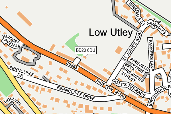
BD20 6DU is located in the Keighley Central electoral ward, within the metropolitan district of Bradford and the English Parliamentary constituency of Keighley. The Sub Integrated Care Board (ICB) Location is NHS West Yorkshire ICB - 36J and the police force is West Yorkshire. This postcode has been in use since January 1980.


GetTheData
Source: OS OpenMap – Local (Ordnance Survey)
Source: OS VectorMap District (Ordnance Survey)
Licence: Open Government Licence (requires attribution)
| Easting | 405178 |
| Northing | 442997 |
| Latitude | 53.883139 |
| Longitude | -1.922714 |
GetTheData
Source: Open Postcode Geo
Licence: Open Government Licence
| Country | England |
| Postcode District | BD20 |
| ➜ BD20 open data dashboard ➜ See where BD20 is on a map ➜ Where is Keighley? | |
GetTheData
Source: Land Registry Price Paid Data
Licence: Open Government Licence
Elevation or altitude of BD20 6DU as distance above sea level:
| Metres | Feet | |
|---|---|---|
| Elevation | 100m | 328ft |
Elevation is measured from the approximate centre of the postcode, to the nearest point on an OS contour line from OS Terrain 50, which has contour spacing of ten vertical metres.
➜ How high above sea level am I? Find the elevation of your current position using your device's GPS.
GetTheData
Source: Open Postcode Elevation
Licence: Open Government Licence
| Ward | Keighley Central |
| Constituency | Keighley |
GetTheData
Source: ONS Postcode Database
Licence: Open Government Licence
| January 2024 | Public order | On or near Ashgrove Road | 38m |
| October 2023 | Vehicle crime | On or near Ashgrove Road | 38m |
| June 2023 | Burglary | On or near Ashgrove Road | 38m |
| ➜ Get more crime data in our Crime section | |||
GetTheData
Source: data.police.uk
Licence: Open Government Licence
| Skipton Rd Ashgrove Road (Skipton Road) | Utley | 42m |
| Skipton Rd Ashgrove Road (Skipton Road) | Utley | 64m |
| Skipton Rd Ferncliffe Drive (Skipton Road) | Utley | 205m |
| Skipton Rd Ferncliffe Drive (Skipton Road) | Utley | 240m |
| Skipton Road Rugby Ground (Skipton Road) | Utley | 255m |
| Keighley Station | 2.2km |
| Steeton & Silsden Station | 2.4km |
GetTheData
Source: NaPTAN
Licence: Open Government Licence
| Percentage of properties with Next Generation Access | 100.0% |
| Percentage of properties with Superfast Broadband | 100.0% |
| Percentage of properties with Ultrafast Broadband | 0.0% |
| Percentage of properties with Full Fibre Broadband | 0.0% |
Superfast Broadband is between 30Mbps and 300Mbps
Ultrafast Broadband is > 300Mbps
| Percentage of properties unable to receive 2Mbps | 0.0% |
| Percentage of properties unable to receive 5Mbps | 0.0% |
| Percentage of properties unable to receive 10Mbps | 0.0% |
| Percentage of properties unable to receive 30Mbps | 0.0% |
GetTheData
Source: Ofcom
Licence: Ofcom Terms of Use (requires attribution)
GetTheData
Source: ONS Postcode Database
Licence: Open Government Licence


➜ Get more ratings from the Food Standards Agency
GetTheData
Source: Food Standards Agency
Licence: FSA terms & conditions
| Last Collection | |||
|---|---|---|---|
| Location | Mon-Fri | Sat | Distance |
| East Ave | 18:00 | 12:15 | 1,408m |
| Highfield P.o. Box | 17:45 | 11:15 | 1,665m |
| 5 Sandywood Street | 18:00 | 12:15 | 1,683m |
GetTheData
Source: Dracos
Licence: Creative Commons Attribution-ShareAlike
| Facility | Distance |
|---|---|
| Utley Recreation Ground St. Johns Court, Low Utley, Keighley Grass Pitches | 114m |
| Leeds City College Recreation Ground Parker's Lane, Keighley Grass Pitches | 220m |
| Keighley Rugby Union Football Club Skipton Road, Keighley Grass Pitches, Artificial Grass Pitch | 265m |
GetTheData
Source: Active Places
Licence: Open Government Licence
| School | Phase of Education | Distance |
|---|---|---|
| Carlton Keighley Green Head Road, Utley, Keighley, BD20 6EB | Secondary | 459m |
| Beechcliffe Special School Green Head Road, Utley, Keighley, BD20 6ED | Not applicable | 487m |
| The Holy Family Catholic School, a Voluntary Academy Spring Gardens Lane, Keighley, BD20 6LH | Secondary | 903m |
GetTheData
Source: Edubase
Licence: Open Government Licence
The below table lists the International Territorial Level (ITL) codes (formerly Nomenclature of Territorial Units for Statistics (NUTS) codes) and Local Administrative Units (LAU) codes for BD20 6DU:
| ITL 1 Code | Name |
|---|---|
| TLE | Yorkshire and The Humber |
| ITL 2 Code | Name |
| TLE4 | West Yorkshire |
| ITL 3 Code | Name |
| TLE41 | Bradford |
| LAU 1 Code | Name |
| E08000032 | Bradford |
GetTheData
Source: ONS Postcode Directory
Licence: Open Government Licence
The below table lists the Census Output Area (OA), Lower Layer Super Output Area (LSOA), and Middle Layer Super Output Area (MSOA) for BD20 6DU:
| Code | Name | |
|---|---|---|
| OA | E00054111 | |
| LSOA | E01010727 | Bradford 007B |
| MSOA | E02002189 | Bradford 007 |
GetTheData
Source: ONS Postcode Directory
Licence: Open Government Licence
| BD20 6DT | Skipton Road | 27m |
| BD20 6HL | Skipton Road | 94m |
| BD20 6DS | Angram Road | 95m |
| BD20 6DN | Aireville Street | 173m |
| BD20 6HN | Ferncliffe Drive | 184m |
| BD20 6DL | Dawslack | 194m |
| BD20 6HP | Skipton Road | 207m |
| BD20 6HB | Howden Avenue | 231m |
| BD20 6UG | Birkdale Court | 233m |
| BD20 6BQ | Gotts Terrace | 238m |
GetTheData
Source: Open Postcode Geo; Land Registry Price Paid Data
Licence: Open Government Licence