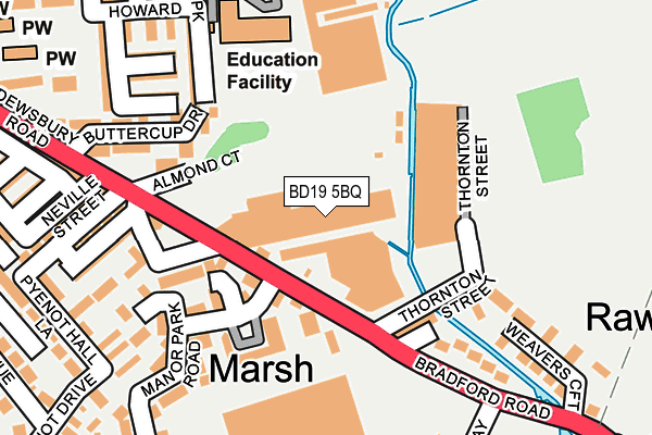
BD19 5BQ is located in the Cleckheaton electoral ward, within the metropolitan district of Kirklees and the English Parliamentary constituency of Batley and Spen. The Sub Integrated Care Board (ICB) Location is NHS West Yorkshire ICB - X2C4Y and the police force is West Yorkshire. This postcode has been in use since December 1995.


GetTheData
Source: OS OpenMap – Local (Ordnance Survey)
Source: OS VectorMap District (Ordnance Survey)
Licence: Open Government Licence (requires attribution)
| Easting | 419493 |
| Northing | 425028 |
| Latitude | 53.721315 |
| Longitude | -1.706081 |
GetTheData
Source: Open Postcode Geo
Licence: Open Government Licence
| Country | England |
| Postcode District | BD19 |
➜ See where BD19 is on a map ➜ Where is Cleckheaton? | |
GetTheData
Source: Land Registry Price Paid Data
Licence: Open Government Licence
Elevation or altitude of BD19 5BQ as distance above sea level:
| Metres | Feet | |
|---|---|---|
| Elevation | 70m | 230ft |
Elevation is measured from the approximate centre of the postcode, to the nearest point on an OS contour line from OS Terrain 50, which has contour spacing of ten vertical metres.
➜ How high above sea level am I? Find the elevation of your current position using your device's GPS.
GetTheData
Source: Open Postcode Elevation
Licence: Open Government Licence
| Ward | Cleckheaton |
| Constituency | Batley And Spen |
GetTheData
Source: ONS Postcode Database
Licence: Open Government Licence
| Bradford Road Thorntonville (Bradford Road) | Cleckheaton | 123m |
| Bradford Road Thorntonville (Bradford Road) | Cleckheaton | 140m |
| Bradford Road Pearson St (Bradford Road) | Cleckheaton | 145m |
| Bradford Road Pearson St (Bradford Road) | Cleckheaton | 176m |
| St Peg Lane St Peg Close (St Peg Lane) | Cleckheaton | 252m |
| Low Moor Station | 4.5km |
| Brighouse Station | 5.5km |
| Dewsbury Station | 5.8km |
GetTheData
Source: NaPTAN
Licence: Open Government Licence
GetTheData
Source: ONS Postcode Database
Licence: Open Government Licence


➜ Get more ratings from the Food Standards Agency
GetTheData
Source: Food Standards Agency
Licence: FSA terms & conditions
| Last Collection | |||
|---|---|---|---|
| Location | Mon-Fri | Sat | Distance |
| Cleckheaton P.o. Box | 18:30 | 12:15 | 528m |
| Spen Junction | 17:30 | 12:15 | 553m |
| Eddercliffe Cres/Bradford | 17:15 | 11:15 | 703m |
GetTheData
Source: Dracos
Licence: Creative Commons Attribution-ShareAlike
| Risk of BD19 5BQ flooding from rivers and sea | Medium |
| ➜ BD19 5BQ flood map | |
GetTheData
Source: Open Flood Risk by Postcode
Licence: Open Government Licence
The below table lists the International Territorial Level (ITL) codes (formerly Nomenclature of Territorial Units for Statistics (NUTS) codes) and Local Administrative Units (LAU) codes for BD19 5BQ:
| ITL 1 Code | Name |
|---|---|
| TLE | Yorkshire and The Humber |
| ITL 2 Code | Name |
| TLE4 | West Yorkshire |
| ITL 3 Code | Name |
| TLE44 | Calderdale and Kirklees |
| LAU 1 Code | Name |
| E08000034 | Kirklees |
GetTheData
Source: ONS Postcode Directory
Licence: Open Government Licence
The below table lists the Census Output Area (OA), Lower Layer Super Output Area (LSOA), and Middle Layer Super Output Area (MSOA) for BD19 5BQ:
| Code | Name | |
|---|---|---|
| OA | E00055777 | |
| LSOA | E01011063 | Kirklees 005C |
| MSOA | E02002275 | Kirklees 005 |
GetTheData
Source: ONS Postcode Directory
Licence: Open Government Licence
| BD19 5BT | Dewsbury Road | 103m |
| BD19 5NB | Thornton Street | 115m |
| BD19 5NA | Thorntonville | 119m |
| BD19 5BL | Manor Park Road | 175m |
| BD19 5LP | Bradford Road | 199m |
| BD19 5NE | Weavers Croft | 201m |
| BD19 5BN | Manor Park Road | 210m |
| BD19 5DJ | Queen Street | 224m |
| BD19 5BW | Marsh Street | 244m |
| BD19 3SF | Howard Park | 247m |
GetTheData
Source: Open Postcode Geo; Land Registry Price Paid Data
Licence: Open Government Licence