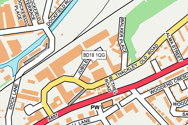
BD18 1QG is located in the Windhill and Wrose electoral ward, within the metropolitan district of Bradford and the English Parliamentary constituency of Shipley. The Sub Integrated Care Board (ICB) Location is NHS West Yorkshire ICB - 36J and the police force is West Yorkshire. This postcode has been in use since January 1992.


GetTheData
Source: OS OpenMap – Local (Ordnance Survey)
Source: OS VectorMap District (Ordnance Survey)
Licence: Open Government Licence (requires attribution)
| Easting | 415579 |
| Northing | 437798 |
| Latitude | 53.836206 |
| Longitude | -1.764750 |
GetTheData
Source: Open Postcode Geo
Licence: Open Government Licence
| Country | England |
| Postcode District | BD18 |
| ➜ BD18 open data dashboard ➜ See where BD18 is on a map ➜ Where is Shipley? | |
GetTheData
Source: Land Registry Price Paid Data
Licence: Open Government Licence
Elevation or altitude of BD18 1QG as distance above sea level:
| Metres | Feet | |
|---|---|---|
| Elevation | 80m | 262ft |
Elevation is measured from the approximate centre of the postcode, to the nearest point on an OS contour line from OS Terrain 50, which has contour spacing of ten vertical metres.
➜ How high above sea level am I? Find the elevation of your current position using your device's GPS.
GetTheData
Source: Open Postcode Elevation
Licence: Open Government Licence
| Ward | Windhill And Wrose |
| Constituency | Shipley |
GetTheData
Source: ONS Postcode Database
Licence: Open Government Licence
| June 2022 | Other theft | On or near Bethel Road | 90m |
| June 2022 | Other theft | On or near Bethel Road | 90m |
| June 2022 | Public order | On or near Bethel Road | 90m |
| ➜ Get more crime data in our Crime section | |||
GetTheData
Source: data.police.uk
Licence: Open Government Licence
| Leeds Rd Wrose Brow Road (Leeds Road) | West Royd | 129m |
| Leeds Rd Wrose Brow Road (Leeds Road) | West Royd | 132m |
| Leeds Rd Thackley Old Road (Leeds Road) | Windhill | 176m |
| Wrose Brow Rd Leeds Road (Wrose Brow Road) | West Royd | 204m |
| Wrose Brow Rd Leeds Road (Wrose Brow Road) | West Royd | 206m |
| Shipley Station | 0.7km |
| Saltaire Station | 1.7km |
| Baildon Station | 1.7km |
GetTheData
Source: NaPTAN
Licence: Open Government Licence
Estimated total energy consumption in BD18 1QG by fuel type, 2015.
| Consumption (kWh) | 237,048 |
|---|---|
| Meter count | 8 |
| Mean (kWh/meter) | 29,631 |
| Median (kWh/meter) | 31,575 |
GetTheData
Source: Postcode level gas estimates: 2015 (experimental)
Source: Postcode level electricity estimates: 2015 (experimental)
Licence: Open Government Licence
GetTheData
Source: ONS Postcode Database
Licence: Open Government Licence


➜ Get more ratings from the Food Standards Agency
GetTheData
Source: Food Standards Agency
Licence: FSA terms & conditions
| Last Collection | |||
|---|---|---|---|
| Location | Mon-Fri | Sat | Distance |
| New Close | 17:30 | 12:30 | 335m |
| Busy Lane P.o. Box | 17:45 | 12:00 | 579m |
| 1 Green Lane Baildon | 17:45 | 12:15 | 774m |
GetTheData
Source: Dracos
Licence: Creative Commons Attribution-ShareAlike
| Facility | Distance |
|---|---|
| Thackley Old Road Rec Ground Thackley Old Road, Shipley Grass Pitches | 216m |
| Windhill Cricket And Athletic Club Busy Lane, Thackley Old Road, Shipley Grass Pitches, Artificial Grass Pitch | 520m |
| Nuffield Health (Shipley) Fred Atkinson Way, Baildon, Shipley Swimming Pool, Health and Fitness Gym, Studio | 569m |
GetTheData
Source: Active Places
Licence: Open Government Licence
| School | Phase of Education | Distance |
|---|---|---|
| Christ Church Church of England Academy Wrose Brow Road, Shipley, BD18 2NT | Primary | 188m |
| Tracks 21 Owlet Road, Shipley, BD18 2LU | Not applicable | 513m |
| Low Ash Primary School Wrose Road, Wrose, Shipley, BD18 1AA | Primary | 903m |
GetTheData
Source: Edubase
Licence: Open Government Licence
The below table lists the International Territorial Level (ITL) codes (formerly Nomenclature of Territorial Units for Statistics (NUTS) codes) and Local Administrative Units (LAU) codes for BD18 1QG:
| ITL 1 Code | Name |
|---|---|
| TLE | Yorkshire and The Humber |
| ITL 2 Code | Name |
| TLE4 | West Yorkshire |
| ITL 3 Code | Name |
| TLE41 | Bradford |
| LAU 1 Code | Name |
| E08000032 | Bradford |
GetTheData
Source: ONS Postcode Directory
Licence: Open Government Licence
The below table lists the Census Output Area (OA), Lower Layer Super Output Area (LSOA), and Middle Layer Super Output Area (MSOA) for BD18 1QG:
| Code | Name | |
|---|---|---|
| OA | E00054347 | |
| LSOA | E01010782 | Bradford 020B |
| MSOA | E02002202 | Bradford 020 |
GetTheData
Source: ONS Postcode Directory
Licence: Open Government Licence
| BD18 1QB | Thackley Old Road | 91m |
| BD18 1BZ | Leeds Road | 101m |
| BD18 1DD | Thackley Old Road | 177m |
| BD18 1DE | Woodville Street | 185m |
| BD17 7BX | Dock Lane | 198m |
| BD18 1BX | Leeds Road | 205m |
| BD18 2PA | Wood End Crescent | 215m |
| BD18 2NW | Hall Lane | 234m |
| BD18 1DG | Alma Street | 245m |
| BD18 2BS | Woodend Crescent | 254m |
GetTheData
Source: Open Postcode Geo; Land Registry Price Paid Data
Licence: Open Government Licence