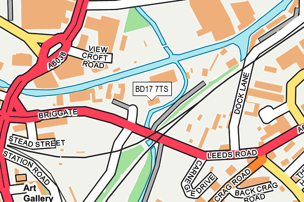
BD17 7TS lies on Tony Miller Approach in Shipley. BD17 7TS is located in the Shipley electoral ward, within the metropolitan district of Bradford and the English Parliamentary constituency of Shipley. The Sub Integrated Care Board (ICB) Location is NHS West Yorkshire ICB - 36J and the police force is West Yorkshire. This postcode has been in use since June 1999.


GetTheData
Source: OS OpenMap – Local (Ordnance Survey)
Source: OS VectorMap District (Ordnance Survey)
Licence: Open Government Licence (requires attribution)
| Easting | 415145 |
| Northing | 437674 |
| Latitude | 53.835119 |
| Longitude | -1.771354 |
GetTheData
Source: Open Postcode Geo
Licence: Open Government Licence
| Street | Tony Miller Approach |
| Town/City | Shipley |
| Country | England |
| Postcode District | BD17 |
➜ See where BD17 is on a map ➜ Where is Shipley? | |
GetTheData
Source: Land Registry Price Paid Data
Licence: Open Government Licence
Elevation or altitude of BD17 7TS as distance above sea level:
| Metres | Feet | |
|---|---|---|
| Elevation | 70m | 230ft |
Elevation is measured from the approximate centre of the postcode, to the nearest point on an OS contour line from OS Terrain 50, which has contour spacing of ten vertical metres.
➜ How high above sea level am I? Find the elevation of your current position using your device's GPS.
GetTheData
Source: Open Postcode Elevation
Licence: Open Government Licence
| Ward | Shipley |
| Constituency | Shipley |
GetTheData
Source: ONS Postcode Database
Licence: Open Government Licence
| Leeds Rd Carnegie Drive (Leeds Road) | Windhill | 74m |
| Leeds Rd Carnegie Drive (Leeds Road) | Windhill | 110m |
| Briggate Charles Street (Briggate) | Shipley | 202m |
| Briggate Otley Road (Briggate) | Shipley | 206m |
| Crag Road Library (Crag Road) | Windhill | 229m |
| Shipley Station | 0.3km |
| Saltaire Station | 1.3km |
| Frizinghall Station | 1.6km |
GetTheData
Source: NaPTAN
Licence: Open Government Licence
GetTheData
Source: ONS Postcode Database
Licence: Open Government Licence


➜ Get more ratings from the Food Standards Agency
GetTheData
Source: Food Standards Agency
Licence: FSA terms & conditions
| Last Collection | |||
|---|---|---|---|
| Location | Mon-Fri | Sat | Distance |
| New Close | 17:30 | 12:30 | 274m |
| 1 Green Lane Baildon | 17:45 | 12:15 | 331m |
| Shipley Delivery Office | 18:30 | 12:45 | 347m |
GetTheData
Source: Dracos
Licence: Creative Commons Attribution-ShareAlike
| Risk of BD17 7TS flooding from rivers and sea | Medium |
| ➜ BD17 7TS flood map | |
GetTheData
Source: Open Flood Risk by Postcode
Licence: Open Government Licence
The below table lists the International Territorial Level (ITL) codes (formerly Nomenclature of Territorial Units for Statistics (NUTS) codes) and Local Administrative Units (LAU) codes for BD17 7TS:
| ITL 1 Code | Name |
|---|---|
| TLE | Yorkshire and The Humber |
| ITL 2 Code | Name |
| TLE4 | West Yorkshire |
| ITL 3 Code | Name |
| TLE41 | Bradford |
| LAU 1 Code | Name |
| E08000032 | Bradford |
GetTheData
Source: ONS Postcode Directory
Licence: Open Government Licence
The below table lists the Census Output Area (OA), Lower Layer Super Output Area (LSOA), and Middle Layer Super Output Area (MSOA) for BD17 7TS:
| Code | Name | |
|---|---|---|
| OA | E00054351 | |
| LSOA | E01010782 | Bradford 020B |
| MSOA | E02002202 | Bradford 020 |
GetTheData
Source: ONS Postcode Directory
Licence: Open Government Licence
| BD17 7BT | Briggate | 69m |
| BD17 7DT | View Croft Road | 134m |
| BD17 7AZ | Dockfield Road | 161m |
| BD18 1BP | Leeds Road | 174m |
| BD17 7DU | View Croft Road | 181m |
| BD17 7BP | Briggate | 213m |
| BD17 7BW | Stead Street | 223m |
| BD17 7AB | Otley Road | 228m |
| BD17 7BL | Charles Street | 234m |
| BD18 2JR | Crag Road | 242m |
GetTheData
Source: Open Postcode Geo; Land Registry Price Paid Data
Licence: Open Government Licence