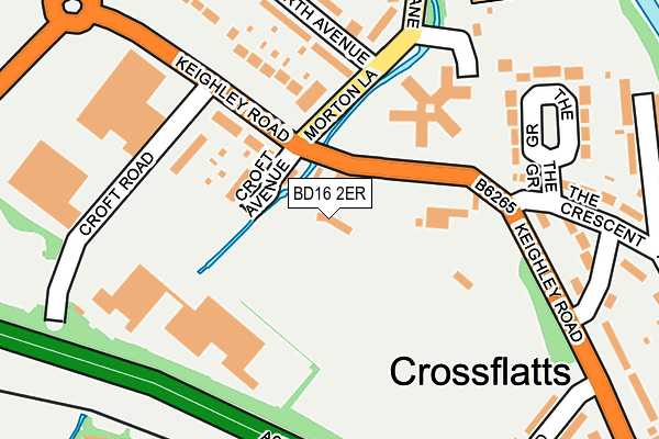
BD16 2ER lies on Keighley Road in Bingley. BD16 2ER is located in the Bingley electoral ward, within the metropolitan district of Bradford and the English Parliamentary constituency of Shipley. The Sub Integrated Care Board (ICB) Location is NHS West Yorkshire ICB - 36J and the police force is West Yorkshire. This postcode has been in use since January 1980.


GetTheData
Source: OS OpenMap – Local (Ordnance Survey)
Source: OS VectorMap District (Ordnance Survey)
Licence: Open Government Licence (requires attribution)
| Easting | 409952 |
| Northing | 440801 |
| Latitude | 53.863333 |
| Longitude | -1.850159 |
GetTheData
Source: Open Postcode Geo
Licence: Open Government Licence
| Street | Keighley Road |
| Town/City | Bingley |
| Country | England |
| Postcode District | BD16 |
| ➜ BD16 open data dashboard ➜ See where BD16 is on a map ➜ Where is Bingley? | |
GetTheData
Source: Land Registry Price Paid Data
Licence: Open Government Licence
Elevation or altitude of BD16 2ER as distance above sea level:
| Metres | Feet | |
|---|---|---|
| Elevation | 90m | 295ft |
Elevation is measured from the approximate centre of the postcode, to the nearest point on an OS contour line from OS Terrain 50, which has contour spacing of ten vertical metres.
➜ How high above sea level am I? Find the elevation of your current position using your device's GPS.
GetTheData
Source: Open Postcode Elevation
Licence: Open Government Licence
| Ward | Bingley |
| Constituency | Shipley |
GetTheData
Source: ONS Postcode Database
Licence: Open Government Licence
| June 2022 | Violence and sexual offences | On or near Croft Avenue | 65m |
| June 2022 | Violence and sexual offences | On or near Ryshworth Avenue | 198m |
| June 2022 | Public order | On or near Ryshworth Avenue | 198m |
| ➜ Get more crime data in our Crime section | |||
GetTheData
Source: data.police.uk
Licence: Open Government Licence
| Morton Lane Druids View (Morton Lane) | Crossflatts | 89m |
| Morton Lane Druids View (Morton Lane) | Crossflatts | 121m |
| Keighley Rd Croft Road (Keighley Road) | Micklethwaite | 185m |
| Keighley Rd Croft Road (Keighley Road) | Micklethwaite | 213m |
| Morton Lane Primary School (Morton Lane) | Crossflatts | 242m |
| Crossflatts Station | 0.6km |
| Bingley Station | 1.8km |
| Keighley Station | 3.4km |
GetTheData
Source: NaPTAN
Licence: Open Government Licence
GetTheData
Source: ONS Postcode Database
Licence: Open Government Licence


➜ Get more ratings from the Food Standards Agency
GetTheData
Source: Food Standards Agency
Licence: FSA terms & conditions
| Last Collection | |||
|---|---|---|---|
| Location | Mon-Fri | Sat | Distance |
| Crossflatts P.o. Box | 17:00 | 12:00 | 401m |
| Wheathead Drive | 17:45 | 12:30 | 1,056m |
| Falcon | 17:30 | 12:30 | 1,127m |
GetTheData
Source: Dracos
Licence: Creative Commons Attribution-ShareAlike
| Facility | Distance |
|---|---|
| Crossflatts Cricket Club Keighley Road, Bingley Grass Pitches | 0m |
| Crossflatts Recreation Ground Queens Road, Bingley Grass Pitches | 207m |
| Crossflatts Primary School Morton Lane, Bingley Grass Pitches | 270m |
GetTheData
Source: Active Places
Licence: Open Government Licence
| School | Phase of Education | Distance |
|---|---|---|
| Crossflatts Primary School Morton Lane, Crossflatts, Bingley, BD16 2EP | Primary | 369m |
| Bingley Grammar School Keighley Road, Bingley, BD16 2RS | Secondary | 882m |
| East Morton CofE Primary School Street Lane, East Morton, Keighley, BD20 5SE | Primary | 1.2km |
GetTheData
Source: Edubase
Licence: Open Government Licence
The below table lists the International Territorial Level (ITL) codes (formerly Nomenclature of Territorial Units for Statistics (NUTS) codes) and Local Administrative Units (LAU) codes for BD16 2ER:
| ITL 1 Code | Name |
|---|---|
| TLE | Yorkshire and The Humber |
| ITL 2 Code | Name |
| TLE4 | West Yorkshire |
| ITL 3 Code | Name |
| TLE41 | Bradford |
| LAU 1 Code | Name |
| E08000032 | Bradford |
GetTheData
Source: ONS Postcode Directory
Licence: Open Government Licence
The below table lists the Census Output Area (OA), Lower Layer Super Output Area (LSOA), and Middle Layer Super Output Area (MSOA) for BD16 2ER:
| Code | Name | |
|---|---|---|
| OA | E00054293 | |
| LSOA | E01010765 | Bradford 010D |
| MSOA | E02002192 | Bradford 010 |
GetTheData
Source: ONS Postcode Directory
Licence: Open Government Licence
| BD16 2DT | Croft Avenue | 89m |
| BD16 2EL | Keighley Road | 90m |
| BD16 2DX | Ryshworth Bridge | 117m |
| BD16 2DU | Croft Road | 140m |
| BD16 2DY | Druids View | 172m |
| BD16 2EH | Ryshworth Avenue | 195m |
| BD16 2ES | The Crescent | 232m |
| BD16 2ET | The Grove | 233m |
| BD16 2EU | The Crescent | 233m |
| BD16 2EJ | Ryshworth Crescent | 255m |
GetTheData
Source: Open Postcode Geo; Land Registry Price Paid Data
Licence: Open Government Licence