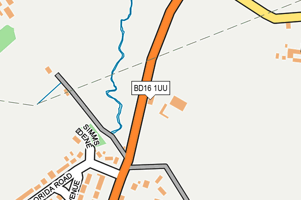
BD16 1UU is located in the Heaton electoral ward, within the metropolitan district of Bradford and the English Parliamentary constituency of Bradford West. The Sub Integrated Care Board (ICB) Location is NHS West Yorkshire ICB - 36J and the police force is West Yorkshire. This postcode has been in use since September 1981.


GetTheData
Source: OS OpenMap – Local (Ordnance Survey)
Source: OS VectorMap District (Ordnance Survey)
Licence: Open Government Licence (requires attribution)
| Easting | 411271 |
| Northing | 435970 |
| Latitude | 53.819901 |
| Longitude | -1.830281 |
GetTheData
Source: Open Postcode Geo
Licence: Open Government Licence
| Country | England |
| Postcode District | BD16 |
| ➜ BD16 open data dashboard ➜ See where BD16 is on a map | |
GetTheData
Source: Land Registry Price Paid Data
Licence: Open Government Licence
Elevation or altitude of BD16 1UU as distance above sea level:
| Metres | Feet | |
|---|---|---|
| Elevation | 190m | 623ft |
Elevation is measured from the approximate centre of the postcode, to the nearest point on an OS contour line from OS Terrain 50, which has contour spacing of ten vertical metres.
➜ How high above sea level am I? Find the elevation of your current position using your device's GPS.
GetTheData
Source: Open Postcode Elevation
Licence: Open Government Licence
| Ward | Heaton |
| Constituency | Bradford West |
GetTheData
Source: ONS Postcode Database
Licence: Open Government Licence
| January 2024 | Drugs | On or near Sandymoor | 276m |
| October 2023 | Violence and sexual offences | On or near Sandymoor | 276m |
| August 2023 | Violence and sexual offences | On or near Sandymoor | 276m |
| ➜ Get more crime data in our Crime section | |||
GetTheData
Source: data.police.uk
Licence: Open Government Licence
| Cottingley Moor Road Florida Rd (Cottingley Moor Road) | Sandy Lane | 130m |
| Cottingley Moor Road Florida Rd (Cottingley Moor Road) | Sandy Lane | 131m |
| Cottingley Moor Rd Lee Lane (Cottingley Moor Road) | Cottingley | 298m |
| Cottingley Moor Rd Lee Lane (Cottingley Moor Road) | Cottingley | 301m |
| Cottingley Moor Rd Lee Lane (Cottingley Moor Road) | Cottingley | 304m |
| Bingley Station | 3.2km |
| Saltaire Station | 3.3km |
| Shipley Station | 4km |
GetTheData
Source: NaPTAN
Licence: Open Government Licence
GetTheData
Source: ONS Postcode Database
Licence: Open Government Licence


➜ Get more ratings from the Food Standards Agency
GetTheData
Source: Food Standards Agency
Licence: FSA terms & conditions
| Last Collection | |||
|---|---|---|---|
| Location | Mon-Fri | Sat | Distance |
| Allerton Franchise P.o. Box | 17:15 | 12:15 | 1,687m |
| 2 Branksome Drive | 18:00 | 12:30 | 1,991m |
| Nabwood Grove | 17:30 | 12:30 | 2,138m |
GetTheData
Source: Dracos
Licence: Creative Commons Attribution-ShareAlike
| Facility | Distance |
|---|---|
| Greenwood Park Cottingley Road, Allerton, Bradford Grass Pitches | 629m |
| Cottingley Village Primary School Cottingley Moor Road, Bingley Grass Pitches | 993m |
| Belle Vue Girls' School Thorn Lane, Bradford Sports Hall | 1.1km |
GetTheData
Source: Active Places
Licence: Open Government Licence
| School | Phase of Education | Distance |
|---|---|---|
| Sandy Lane Primary School Cottingley Road, Allerton, Bradford, BD15 9JU | Primary | 454m |
| Cottingley Village Primary School Cottingley Moor Road, Cottingley, Bingley, BD16 1SY | Primary | 1km |
| Belle Vue Girls' Academy Thorn Lane, Bingley Road, Bradford, BD9 6NA | Secondary | 1.1km |
GetTheData
Source: Edubase
Licence: Open Government Licence
The below table lists the International Territorial Level (ITL) codes (formerly Nomenclature of Territorial Units for Statistics (NUTS) codes) and Local Administrative Units (LAU) codes for BD16 1UU:
| ITL 1 Code | Name |
|---|---|
| TLE | Yorkshire and The Humber |
| ITL 2 Code | Name |
| TLE4 | West Yorkshire |
| ITL 3 Code | Name |
| TLE41 | Bradford |
| LAU 1 Code | Name |
| E08000032 | Bradford |
GetTheData
Source: ONS Postcode Directory
Licence: Open Government Licence
The below table lists the Census Output Area (OA), Lower Layer Super Output Area (LSOA), and Middle Layer Super Output Area (MSOA) for BD16 1UU:
| Code | Name | |
|---|---|---|
| OA | E00053473 | |
| LSOA | E01010587 | Bradford 022B |
| MSOA | E02002204 | Bradford 022 |
GetTheData
Source: ONS Postcode Directory
Licence: Open Government Licence
| BD15 9LH | Cottingley Road | 181m |
| BD15 9LE | Florida Road | 245m |
| BD15 9LD | Cottingley Road | 256m |
| BD15 9LF | Sandymoor | 263m |
| BD15 9LB | Syringa Avenue | 307m |
| BD15 9JU | Cottingley Road | 344m |
| BD15 9DB | Acacia Drive | 371m |
| BD15 9JZ | Meadow Court | 377m |
| BD15 9JY | Acacia Drive | 429m |
| BD15 9LA | Aspen Rise | 453m |
GetTheData
Source: Open Postcode Geo; Land Registry Price Paid Data
Licence: Open Government Licence