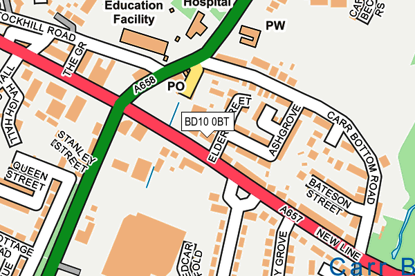
BD10 0BT is located in the Idle and Thackley electoral ward, within the metropolitan district of Bradford and the English Parliamentary constituency of Bradford East. The Sub Integrated Care Board (ICB) Location is NHS West Yorkshire ICB - 36J and the police force is West Yorkshire. This postcode has been in use since June 1998.


GetTheData
Source: OS OpenMap – Local (Ordnance Survey)
Source: OS VectorMap District (Ordnance Survey)
Licence: Open Government Licence (requires attribution)
| Easting | 419170 |
| Northing | 437229 |
| Latitude | 53.830973 |
| Longitude | -1.710219 |
GetTheData
Source: Open Postcode Geo
Licence: Open Government Licence
| Country | England |
| Postcode District | BD10 |
| ➜ BD10 open data dashboard ➜ See where BD10 is on a map ➜ Where is Bradford? | |
GetTheData
Source: Land Registry Price Paid Data
Licence: Open Government Licence
Elevation or altitude of BD10 0BT as distance above sea level:
| Metres | Feet | |
|---|---|---|
| Elevation | 90m | 295ft |
Elevation is measured from the approximate centre of the postcode, to the nearest point on an OS contour line from OS Terrain 50, which has contour spacing of ten vertical metres.
➜ How high above sea level am I? Find the elevation of your current position using your device's GPS.
GetTheData
Source: Open Postcode Elevation
Licence: Open Government Licence
| Ward | Idle And Thackley |
| Constituency | Bradford East |
GetTheData
Source: ONS Postcode Database
Licence: Open Government Licence
| January 2024 | Other theft | On or near Petrol Station | 292m |
| January 2024 | Other theft | On or near Petrol Station | 292m |
| December 2023 | Violence and sexual offences | On or near Petrol Station | 292m |
| ➜ Get more crime data in our Crime section | |||
GetTheData
Source: data.police.uk
Licence: Open Government Licence
| New Line Elder Street (New Line) | Greengates | 49m |
| Redcar Road New Line (Redcar Road) | Greengates | 69m |
| New Line Redcar Road (New Line) | Greengates | 84m |
| Redcar Road New Line (Redcar Road) | Greengates | 89m |
| Harrogate Rd Stockhill Road (Harrogate Road) | Greengates | 119m |
| Apperley Bridge Station | 1.2km |
| New Pudsey Station | 3.5km |
| Baildon Station | 3.6km |
GetTheData
Source: NaPTAN
Licence: Open Government Licence
GetTheData
Source: ONS Postcode Database
Licence: Open Government Licence


➜ Get more ratings from the Food Standards Agency
GetTheData
Source: Food Standards Agency
Licence: FSA terms & conditions
| Last Collection | |||
|---|---|---|---|
| Location | Mon-Fri | Sat | Distance |
| Apperley Bridge | 17:15 | 12:00 | 89m |
| Greengates P.o. Box | 17:15 | 12:15 | 105m |
| 28 Redcar Road | 17:45 | 12:00 | 236m |
GetTheData
Source: Dracos
Licence: Creative Commons Attribution-ShareAlike
| Facility | Distance |
|---|---|
| Jetts Greengates Harrogate Road, Bradford Health and Fitness Gym, Studio | 132m |
| Greengates Primary Academy Stockhill Road, Bradford Grass Pitches | 166m |
| Greengates Recreation Ground Brunswick Road, Bradford Grass Pitches | 363m |
GetTheData
Source: Active Places
Licence: Open Government Licence
| School | Phase of Education | Distance |
|---|---|---|
| Greengates Primary Academy 31 Stockhill Road, Greengates, Bradford, BD10 9AX | Primary | 166m |
| Co-op Academy Parkland Old Park Road, Thorpe Edge, Bradford, BD10 9BG | Primary | 590m |
| Holybrook Primary School Rillington Mead, Greengates, Bradford, BD10 0EF | Primary | 698m |
GetTheData
Source: Edubase
Licence: Open Government Licence
The below table lists the International Territorial Level (ITL) codes (formerly Nomenclature of Territorial Units for Statistics (NUTS) codes) and Local Administrative Units (LAU) codes for BD10 0BT:
| ITL 1 Code | Name |
|---|---|
| TLE | Yorkshire and The Humber |
| ITL 2 Code | Name |
| TLE4 | West Yorkshire |
| ITL 3 Code | Name |
| TLE41 | Bradford |
| LAU 1 Code | Name |
| E08000032 | Bradford |
GetTheData
Source: ONS Postcode Directory
Licence: Open Government Licence
The below table lists the Census Output Area (OA), Lower Layer Super Output Area (LSOA), and Middle Layer Super Output Area (MSOA) for BD10 0BT:
| Code | Name | |
|---|---|---|
| OA | E00053897 | |
| LSOA | E01010689 | Bradford 019F |
| MSOA | E02002201 | Bradford 019 |
GetTheData
Source: ONS Postcode Directory
Licence: Open Government Licence
| BD10 0BX | New Line | 47m |
| BD10 0BS | Elder Street | 53m |
| BD10 0BP | Ashgrove | 77m |
| BD10 0BA | Barraclough Buildings | 81m |
| BD10 0BW | Ash Mews | 94m |
| BD10 0BB | Carrbottom Road | 96m |
| BD10 0RA | Harrogate Road | 98m |
| BD10 0RB | Harrogate Road | 134m |
| BD10 0BL | New Line | 135m |
| BD10 0BN | New Line | 157m |
GetTheData
Source: Open Postcode Geo; Land Registry Price Paid Data
Licence: Open Government Licence