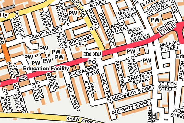
BB8 0BU lies on Albert Road in Colne. BB8 0BU is located in the Waterside & Horsfield electoral ward, within the local authority district of Pendle and the English Parliamentary constituency of Pendle. The Sub Integrated Care Board (ICB) Location is NHS Lancashire and South Cumbria ICB - 01A and the police force is Lancashire. This postcode has been in use since December 2000.


GetTheData
Source: OS OpenMap – Local (Ordnance Survey)
Source: OS VectorMap District (Ordnance Survey)
Licence: Open Government Licence (requires attribution)
| Easting | 388652 |
| Northing | 439975 |
| Latitude | 53.855876 |
| Longitude | -2.174004 |
GetTheData
Source: Open Postcode Geo
Licence: Open Government Licence
| Street | Albert Road |
| Town/City | Colne |
| Country | England |
| Postcode District | BB8 |
| ➜ BB8 open data dashboard ➜ See where BB8 is on a map ➜ Where is Colne? | |
GetTheData
Source: Land Registry Price Paid Data
Licence: Open Government Licence
Elevation or altitude of BB8 0BU as distance above sea level:
| Metres | Feet | |
|---|---|---|
| Elevation | 170m | 558ft |
Elevation is measured from the approximate centre of the postcode, to the nearest point on an OS contour line from OS Terrain 50, which has contour spacing of ten vertical metres.
➜ How high above sea level am I? Find the elevation of your current position using your device's GPS.
GetTheData
Source: Open Postcode Elevation
Licence: Open Government Licence
| Ward | Waterside & Horsfield |
| Constituency | Pendle |
GetTheData
Source: ONS Postcode Database
Licence: Open Government Licence
| November 2023 | Violence and sexual offences | On or near Brown Street East | 82m |
| November 2023 | Violence and sexual offences | On or near Brown Street East | 82m |
| November 2023 | Violence and sexual offences | On or near Brown Street East | 82m |
| ➜ Get more crime data in our Crime section | |||
GetTheData
Source: data.police.uk
Licence: Open Government Licence
| Municipal Hall (Albert Road) | Colne | 93m |
| Municipal Hall (Albert Road) | Colne | 108m |
| St Johns Church (Albert Road) | Colne | 185m |
| Lancaster Street (North Valley Road) | Colne | 219m |
| Walton Street | Colne | 293m |
| Colne Station | 0.5km |
| Nelson Station | 3.5km |
| Brierfield Station | 5.4km |
GetTheData
Source: NaPTAN
Licence: Open Government Licence
GetTheData
Source: ONS Postcode Database
Licence: Open Government Licence


➜ Get more ratings from the Food Standards Agency
GetTheData
Source: Food Standards Agency
Licence: FSA terms & conditions
| Last Collection | |||
|---|---|---|---|
| Location | Mon-Fri | Sat | Distance |
| Colne Post Office | 17:00 | 7m | |
| Colne Post Office | 18:00 | 12:00 | 9m |
| Broken Banks | 16:00 | 11:00 | 181m |
GetTheData
Source: Dracos
Licence: Creative Commons Attribution-ShareAlike
| Facility | Distance |
|---|---|
| Intershape Fitness (Colne, Albert Road) Albert Road, Colne Health and Fitness Gym, Studio | 46m |
| Pendle Leisure Centre Crown Way, Colne Sports Hall, Swimming Pool, Health and Fitness Gym, Artificial Grass Pitch, Studio | 497m |
| Intershape Fitness (Colne,market Street) Market Street, Colne Health and Fitness Gym, Studio | 635m |
GetTheData
Source: Active Places
Licence: Open Government Licence
| School | Phase of Education | Distance |
|---|---|---|
| Colne Lord Street School Lord Street, Colne, BB8 9AR | Primary | 292m |
| West Street Community Primary School West Street, Colne, BB8 0HW | Primary | 452m |
| Newtown Nursery School West Street, Colne, BB8 0HP | Nursery | 744m |
GetTheData
Source: Edubase
Licence: Open Government Licence
The below table lists the International Territorial Level (ITL) codes (formerly Nomenclature of Territorial Units for Statistics (NUTS) codes) and Local Administrative Units (LAU) codes for BB8 0BU:
| ITL 1 Code | Name |
|---|---|
| TLD | North West (England) |
| ITL 2 Code | Name |
| TLD4 | Lancashire |
| ITL 3 Code | Name |
| TLD46 | East Lancashire |
| LAU 1 Code | Name |
| E07000122 | Pendle |
GetTheData
Source: ONS Postcode Directory
Licence: Open Government Licence
The below table lists the Census Output Area (OA), Lower Layer Super Output Area (LSOA), and Middle Layer Super Output Area (MSOA) for BB8 0BU:
| Code | Name | |
|---|---|---|
| OA | E00128045 | |
| LSOA | E01025226 | Pendle 007A |
| MSOA | E02005246 | Pendle 007 |
GetTheData
Source: ONS Postcode Directory
Licence: Open Government Licence
| BB8 0AD | Albert Road | 32m |
| BB8 0AB | Albert Road | 67m |
| BB8 0RY | Albert Road | 70m |
| BB8 9BB | Brown Street East | 72m |
| BB8 0DJ | Hall Street | 78m |
| BB8 9BQ | Spring Court | 97m |
| BB8 9BA | Linden Road | 101m |
| BB8 9BD | Spring Lane | 110m |
| BB8 0BP | Albert Road | 111m |
| BB8 0SU | Duke Street | 111m |
GetTheData
Source: Open Postcode Geo; Land Registry Price Paid Data
Licence: Open Government Licence