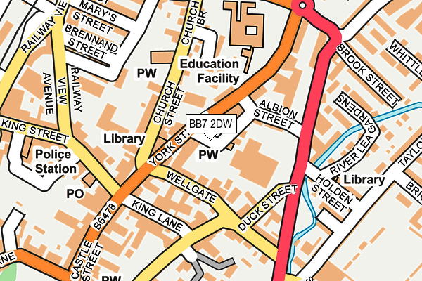
BB7 2DW is located in the Salthill electoral ward, within the local authority district of Ribble Valley and the English Parliamentary constituency of Ribble Valley. The Sub Integrated Care Board (ICB) Location is NHS Lancashire and South Cumbria ICB - 01A and the police force is Lancashire. This postcode has been in use since January 1980.


GetTheData
Source: OS OpenMap – Local (Ordnance Survey)
Source: OS VectorMap District (Ordnance Survey)
Licence: Open Government Licence (requires attribution)
| Easting | 374499 |
| Northing | 441955 |
| Latitude | 53.873166 |
| Longitude | -2.389330 |
GetTheData
Source: Open Postcode Geo
Licence: Open Government Licence
| Country | England |
| Postcode District | BB7 |
| ➜ BB7 open data dashboard ➜ See where BB7 is on a map ➜ Where is Clitheroe? | |
GetTheData
Source: Land Registry Price Paid Data
Licence: Open Government Licence
Elevation or altitude of BB7 2DW as distance above sea level:
| Metres | Feet | |
|---|---|---|
| Elevation | 80m | 262ft |
Elevation is measured from the approximate centre of the postcode, to the nearest point on an OS contour line from OS Terrain 50, which has contour spacing of ten vertical metres.
➜ How high above sea level am I? Find the elevation of your current position using your device's GPS.
GetTheData
Source: Open Postcode Elevation
Licence: Open Government Licence
| Ward | Salthill |
| Constituency | Ribble Valley |
GetTheData
Source: ONS Postcode Database
Licence: Open Government Licence
| January 2024 | Burglary | On or near Petrol Station | 258m |
| January 2024 | Anti-social behaviour | On or near Petrol Station | 258m |
| January 2024 | Anti-social behaviour | On or near Petrol Station | 258m |
| ➜ Get more crime data in our Crime section | |||
GetTheData
Source: data.police.uk
Licence: Open Government Licence
| York Street (Back Church Brow Path) | Clitheroe Town Centre | 39m |
| York Street Sch Stop (York Street) | Clitheroe Town Centre | 47m |
| Tesco (Duck Street) | Clitheroe Town Centre | 122m |
| Market Place | Clitheroe Town Centre | 126m |
| King Lane | Clitheroe Town Centre | 137m |
| Clitheroe Station | 0.3km |
GetTheData
Source: NaPTAN
Licence: Open Government Licence
GetTheData
Source: ONS Postcode Database
Licence: Open Government Licence


➜ Get more ratings from the Food Standards Agency
GetTheData
Source: Food Standards Agency
Licence: FSA terms & conditions
| Last Collection | |||
|---|---|---|---|
| Location | Mon-Fri | Sat | Distance |
| 144 Chatburn Road | 16:00 | 11:30 | 799m |
| 2 Beverley Drive | 17:00 | 11:00 | 1,238m |
GetTheData
Source: Dracos
Licence: Creative Commons Attribution-ShareAlike
| Facility | Distance |
|---|---|
| Lee Carter Leisure (Closed) Lowergate, Clitheroe Health and Fitness Gym, Studio | 159m |
| Clitheroe Fc Shawbridge, Pendle Road, Clitheroe Grass Pitches | 311m |
| St. Michaels & St. Johns Rc Primary School Lowergate, Clitheroe Grass Pitches, Sports Hall | 324m |
GetTheData
Source: Active Places
Licence: Open Government Licence
| School | Phase of Education | Distance |
|---|---|---|
| Clitheroe Royal Grammar School York Street, Clitheroe, BB7 2DJ | Secondary | 176m |
| St Michael and St John's Roman Catholic Primary School, Clitheroe Lowergate, Clitheroe, BB7 1AG | Primary | 363m |
| Clitheroe Pendle Primary School Princess Avenue, Clitheroe, BB7 2AL | Primary | 430m |
GetTheData
Source: Edubase
Licence: Open Government Licence
The below table lists the International Territorial Level (ITL) codes (formerly Nomenclature of Territorial Units for Statistics (NUTS) codes) and Local Administrative Units (LAU) codes for BB7 2DW:
| ITL 1 Code | Name |
|---|---|
| TLD | North West (England) |
| ITL 2 Code | Name |
| TLD4 | Lancashire |
| ITL 3 Code | Name |
| TLD45 | Mid Lancashire |
| LAU 1 Code | Name |
| E07000124 | Ribble Valley |
GetTheData
Source: ONS Postcode Directory
Licence: Open Government Licence
The below table lists the Census Output Area (OA), Lower Layer Super Output Area (LSOA), and Middle Layer Super Output Area (MSOA) for BB7 2DW:
| Code | Name | |
|---|---|---|
| OA | E00128643 | |
| LSOA | E01025346 | Ribble Valley 002D |
| MSOA | E02005271 | Ribble Valley 002 |
GetTheData
Source: ONS Postcode Directory
Licence: Open Government Licence
| BB7 1LT | Back York Street | 30m |
| BB7 2DH | York Street | 59m |
| BB7 2DP | Wellgate | 62m |
| BB7 2DG | Church Street | 69m |
| BB7 1QH | Albion Place | 72m |
| BB7 1LS | Albion Street | 84m |
| BB7 2DS | Wellgate | 89m |
| BB7 2DD | Church Street | 93m |
| BB7 2DL | York Street | 103m |
| BB7 2DA | Market Place | 114m |
GetTheData
Source: Open Postcode Geo; Land Registry Price Paid Data
Licence: Open Government Licence