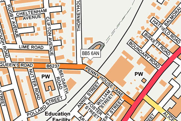
BB5 6AN lies on Strawberry Bank in Accrington. BB5 6AN is located in the Milnshaw electoral ward, within the local authority district of Hyndburn and the English Parliamentary constituency of Hyndburn. The Sub Integrated Care Board (ICB) Location is NHS Lancashire and South Cumbria ICB - 01A and the police force is Lancashire. This postcode has been in use since January 1980.


GetTheData
Source: OS OpenMap – Local (Ordnance Survey)
Source: OS VectorMap District (Ordnance Survey)
Licence: Open Government Licence (requires attribution)
| Easting | 376348 |
| Northing | 429349 |
| Latitude | 53.759970 |
| Longitude | -2.360235 |
GetTheData
Source: Open Postcode Geo
Licence: Open Government Licence
| Street | Strawberry Bank |
| Town/City | Accrington |
| Country | England |
| Postcode District | BB5 |
| ➜ BB5 open data dashboard ➜ See where BB5 is on a map ➜ Where is Accrington? | |
GetTheData
Source: Land Registry Price Paid Data
Licence: Open Government Licence
Elevation or altitude of BB5 6AN as distance above sea level:
| Metres | Feet | |
|---|---|---|
| Elevation | 160m | 525ft |
Elevation is measured from the approximate centre of the postcode, to the nearest point on an OS contour line from OS Terrain 50, which has contour spacing of ten vertical metres.
➜ How high above sea level am I? Find the elevation of your current position using your device's GPS.
GetTheData
Source: Open Postcode Elevation
Licence: Open Government Licence
| Ward | Milnshaw |
| Constituency | Hyndburn |
GetTheData
Source: ONS Postcode Database
Licence: Open Government Licence
| January 2024 | Anti-social behaviour | On or near Railway View | 476m |
| December 2023 | Criminal damage and arson | On or near Railway View | 476m |
| December 2023 | Drugs | On or near Railway View | 476m |
| ➜ Get more crime data in our Crime section | |||
GetTheData
Source: data.police.uk
Licence: Open Government Licence
| Thorneyholme Road (Queens Road) | Laneside | 60m |
| William Street (Penny House Lane) | Hillock Vale | 126m |
| William Street (Penny House Lane) | Hillock Vale | 128m |
| Alice Street (Burnley Road) | Hillock Vale | 204m |
| Moss Hall Road (Thorneyholme Road) | Laneside | 212m |
| Accrington Station | 1km |
| Huncoat Station | 1.6km |
| Church & Oswaldtwistle Station | 2.3km |
GetTheData
Source: NaPTAN
Licence: Open Government Licence
| Percentage of properties with Next Generation Access | 100.0% |
| Percentage of properties with Superfast Broadband | 100.0% |
| Percentage of properties with Ultrafast Broadband | 100.0% |
| Percentage of properties with Full Fibre Broadband | 0.0% |
Superfast Broadband is between 30Mbps and 300Mbps
Ultrafast Broadband is > 300Mbps
| Percentage of properties unable to receive 2Mbps | 0.0% |
| Percentage of properties unable to receive 5Mbps | 0.0% |
| Percentage of properties unable to receive 10Mbps | 0.0% |
| Percentage of properties unable to receive 30Mbps | 0.0% |
GetTheData
Source: Ofcom
Licence: Ofcom Terms of Use (requires attribution)
GetTheData
Source: ONS Postcode Database
Licence: Open Government Licence


➜ Get more ratings from the Food Standards Agency
GetTheData
Source: Food Standards Agency
Licence: FSA terms & conditions
| Last Collection | |||
|---|---|---|---|
| Location | Mon-Fri | Sat | Distance |
| 52 Lancaster Avenue | 16:15 | 11:15 | 1,279m |
| 216 Willows Lane | 17:00 | 12:45 | 1,831m |
| Clayton Le Moors Post Office | 16:45 | 12:15 | 2,057m |
GetTheData
Source: Dracos
Licence: Creative Commons Attribution-ShareAlike
| Facility | Distance |
|---|---|
| Stanley Sports Hub Thorneyholme Road, Accrington Grass Pitches, Artificial Grass Pitch | 295m |
| Peel Park Primary School Alice Street, Accrington Grass Pitches | 332m |
| Accrington Cricket And Tennis Club Thorneyholme Road, Accrington Grass Pitches, Outdoor Tennis Courts | 588m |
GetTheData
Source: Active Places
Licence: Open Government Licence
| School | Phase of Education | Distance |
|---|---|---|
| Accrington St John with St Augustine Church of England Primary School Maudsley Street, Accrington, BB5 6AD | Primary | 221m |
| Accrington Peel Park Primary School Alice Street, Accrington, BB5 6QR | Primary | 452m |
| Accrington St Mary Magdalen's Church of England Primary School Devonshire Street, Accrington, BB5 1DW | Primary | 628m |
GetTheData
Source: Edubase
Licence: Open Government Licence
The below table lists the International Territorial Level (ITL) codes (formerly Nomenclature of Territorial Units for Statistics (NUTS) codes) and Local Administrative Units (LAU) codes for BB5 6AN:
| ITL 1 Code | Name |
|---|---|
| TLD | North West (England) |
| ITL 2 Code | Name |
| TLD4 | Lancashire |
| ITL 3 Code | Name |
| TLD46 | East Lancashire |
| LAU 1 Code | Name |
| E07000120 | Hyndburn |
GetTheData
Source: ONS Postcode Directory
Licence: Open Government Licence
The below table lists the Census Output Area (OA), Lower Layer Super Output Area (LSOA), and Middle Layer Super Output Area (MSOA) for BB5 6AN:
| Code | Name | |
|---|---|---|
| OA | E00127169 | |
| LSOA | E01025057 | Hyndburn 004C |
| MSOA | E02005215 | Hyndburn 004 |
GetTheData
Source: ONS Postcode Directory
Licence: Open Government Licence
| BB5 6AL | Penny House Lane | 103m |
| BB5 6BH | Eton Avenue | 106m |
| BB5 6AP | Queens Road | 113m |
| BB5 6BD | Thorneyholme Road | 127m |
| BB5 6AJ | Foster Street | 133m |
| BB5 6DT | William Street | 140m |
| BB5 6BQ | Harrow Avenue | 152m |
| BB5 6AQ | Annie Street | 158m |
| BB5 6DQ | Boundary Road | 168m |
| BB5 6DY | Robert Street | 169m |
GetTheData
Source: Open Postcode Geo; Land Registry Price Paid Data
Licence: Open Government Licence